
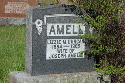

Lizzie M. Duncan Amell
| Birth | : | 1884 |
| Death | : | 22 Jul 1965 Perth, Lanark County, Ontario, Canada |
| Burial | : | All Saints Churchyard, Lullington, Mendip District, England |
| Coordinate | : | 51.2661940, -2.3121800 |
| Plot | : | 290 |
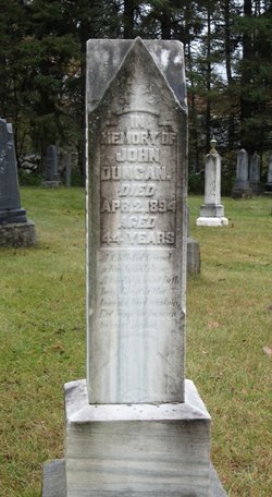
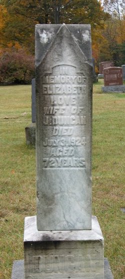
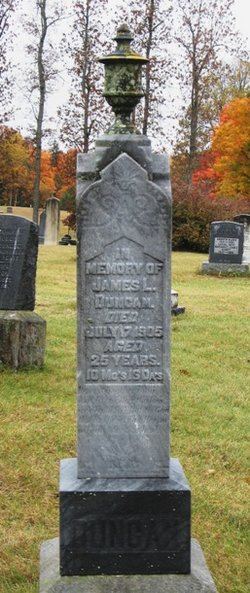
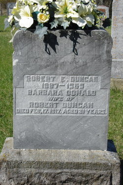
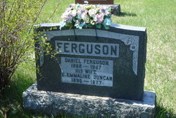
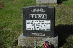
| Description | : | Lizzie was the daughter of John Duncan & Elizabeth Love. She was married to Joseph Amell on July 24, 1907. Joseph died Oct.6,1941 an is buried in Plot 21 of St. Columbkill's Roman Catholic Cemetery, McDonald's Corners, with his parents. ------------------------------------ Plot 290 : - Lizzie M. Duncan 1884-1965, wife of Joseph Amell. |
frequently asked questions (FAQ):
-
Where is Lizzie M. Duncan Amell's memorial?
Lizzie M. Duncan Amell's memorial is located at: All Saints Churchyard, Lullington, Mendip District, England.
-
When did Lizzie M. Duncan Amell death?
Lizzie M. Duncan Amell death on 22 Jul 1965 in Perth, Lanark County, Ontario, Canada
-
Where are the coordinates of the Lizzie M. Duncan Amell's memorial?
Latitude: 51.2661940
Longitude: -2.3121800
Family Members:
Parent
Spouse

Siblings


Flowers:


Nearby Cemetories:
1. All Saints Churchyard
Lullington, Mendip District, England
Coordinate: 51.2661940, -2.3121800
2. St Mary's Churchyard
Laverton, Mendip District, England
Coordinate: 51.2757380, -2.3195910
3. St Mary the Virgin Churchyard
Orchardleigh, Mendip District, England
Coordinate: 51.2576210, -2.3259440
4. Beckington Baptist Chapel Burial Ground
Beckington, Mendip District, England
Coordinate: 51.2610760, -2.2897000
5. St George Churchyard
Beckington, Mendip District, England
Coordinate: 51.2635260, -2.2856810
6. St. Lawrence Churchyard
Woolverton, Mendip District, England
Coordinate: 51.2851540, -2.3021790
7. Saint Michael & All Angels Churchyard
Buckland Dinham, Mendip District, England
Coordinate: 51.2600540, -2.3522580
8. St Lawrence Churchyard
Rode, Mendip District, England
Coordinate: 51.2792750, -2.2765370
9. Christ Church Churchyard
Rode, Mendip District, England
Coordinate: 51.2861620, -2.2790890
10. Holy Trinity Church
Frome, Mendip District, England
Coordinate: 51.2341720, -2.3275820
11. St. Mary's Berkley
Berkley, Mendip District, England
Coordinate: 51.2435080, -2.2720990
12. Frome Dissenters' Cemetery
Frome, Mendip District, England
Coordinate: 51.2317000, -2.3215000
13. Norton St. Philip Churchyard
Norton St Philip, Mendip District, England
Coordinate: 51.3001680, -2.3279700
14. All Saints Churchyard
Tellisford, Mendip District, England
Coordinate: 51.2997270, -2.2877180
15. St. John the Baptist Churchyard
Frome, Mendip District, England
Coordinate: 51.2296780, -2.3209480
16. Sheppards Barton Meeting House Burial Ground
Frome, Mendip District, England
Coordinate: 51.2300570, -2.3247620
17. Christ Church Churchyard
Frome, Mendip District, England
Coordinate: 51.2295340, -2.3260130
18. East Hill Cemetery
Frome, Mendip District, England
Coordinate: 51.2275940, -2.3030250
19. East Hill
Frome St Quintin, West Dorset District, England
Coordinate: 51.2272132, -2.3024896
20. All Saints Churchyard
Rodden, Mendip District, England
Coordinate: 51.2283600, -2.2892740
21. Saint Mary Magdalene Churchyard
Great Elm, Mendip District, England
Coordinate: 51.2426040, -2.3647230
22. Blessed St Mary the Virgin Churchyard
Hemington, Mendip District, England
Coordinate: 51.2758698, -2.3925455
23. St Leonard Churchyard
Farleigh Hungerford, Mendip District, England
Coordinate: 51.3155390, -2.2884820
24. Farleigh Hungerford Castle
Farleigh Hungerford, Mendip District, England
Coordinate: 51.3173500, -2.2869590