
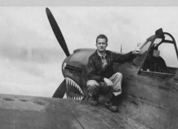

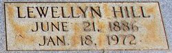
Llewellyn Hill “Louie” Couch Jr.
| Birth | : | 10 Dec 1919 Pontiac, Oakland County, Michigan, USA |
| Death | : | 28 Aug 1948 New York County (Manhattan), New York, USA |
| Burial | : | Saint Francis Xavier Cemetery, Renfrew, Renfrew County, Canada |
| Coordinate | : | 45.4872100, -76.6921600 |
| Plot | : | L 3 |
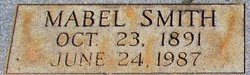
| Description | : | Louie was the son of Llewellyn Hill Couch, Sr. and Mabel Smith, dau. of Horace McNair Smith and Mary Jane Stevens. He earned the rank of Major during WWII as a pilot in the Flying Tigers. He was awarded the Silver Star, the Air Medal and a Purple Heart for his combat missions. Louie later became a Pan American commerical pilot. New York Times August 30, 1948 Llewellyn H. Couch, Jr., a pilot navigator(Captain) for Pan American World Airways, died at Presbyterian Hospital three hours after he had been flown to New York La Guardia field from Accra, British West Africa(now... Read More |
frequently asked questions (FAQ):
-
Where is Llewellyn Hill “Louie” Couch Jr.'s memorial?
Llewellyn Hill “Louie” Couch Jr.'s memorial is located at: Saint Francis Xavier Cemetery, Renfrew, Renfrew County, Canada.
-
When did Llewellyn Hill “Louie” Couch Jr. death?
Llewellyn Hill “Louie” Couch Jr. death on 28 Aug 1948 in New York County (Manhattan), New York, USA
-
Where are the coordinates of the Llewellyn Hill “Louie” Couch Jr.'s memorial?
Latitude: 45.4872100
Longitude: -76.6921600
Family Members:
Parent
Children
Flowers:


Nearby Cemetories:
1. Saint Francis Xavier Cemetery
Renfrew, Renfrew County, Canada
Coordinate: 45.4872100, -76.6921600
2. North Horton Cemetery
Renfrew, Renfrew County, Canada
Coordinate: 45.5177800, -76.6718355
3. Thompson Hill Cemetery
Thompson Hill, Renfrew County, Canada
Coordinate: 45.4567900, -76.6710200
4. McLaren Cemetery
Renfrew, Renfrew County, Canada
Coordinate: 45.4553800, -76.6632200
5. Costello Cemetery
Horton, Renfrew County, Canada
Coordinate: 45.4684307, -76.6346983
6. Old Martin Cemetery
Horton, Renfrew County, Canada
Coordinate: 45.4673350, -76.6318680
7. Admaston Cemetery
Admaston, Renfrew County, Canada
Coordinate: 45.4568750, -76.7694830
8. Rosebank Cemetery
Rosebank, Renfrew County, Canada
Coordinate: 45.5251000, -76.7829110
9. Goshen Public Cemetery
Goshen, Renfrew County, Canada
Coordinate: 45.4377130, -76.5794520
10. Fraser Cemetery
Burnstown, Renfrew County, Canada
Coordinate: 45.3903130, -76.6384360
11. St. George Anglican Church Cemetery
Portage-du-Fort, Outaouais Region, Canada
Coordinate: 45.5934170, -76.6678210
12. Protestant Cemetery of Portage du Fort
Portage-du-Fort, Outaouais Region, Canada
Coordinate: 45.5926410, -76.6584030
13. St. James Roman Catholic Cemetery
Portage-du-Fort, Outaouais Region, Canada
Coordinate: 45.5929000, -76.6582800
14. Haley Cemetery
Haley Station, Renfrew County, Canada
Coordinate: 45.5722300, -76.7880700
15. Castleford Union Cemetery
Castleford, Renfrew County, Canada
Coordinate: 45.5100900, -76.5395200
16. Austin United Cemetery
Clarendon Front, Outaouais Region, Canada
Coordinate: 45.5589610, -76.5529840
17. St. James the Greater Cemetery
Portage-du-Fort, Outaouais Region, Canada
Coordinate: 45.6091700, -76.6508400
18. Springtown Protestant Cemetery
Springtown, Renfrew County, Canada
Coordinate: 45.3540590, -76.6487820
19. Saint Gabriel's Roman Catholic Cemetery
Springtown, Renfrew County, Canada
Coordinate: 45.3468860, -76.6621210
20. Old Clarendon Cemetery
Clarendon, Outaouais Region, Canada
Coordinate: 45.5342450, -76.5005850
21. Litchfield United Cemetery
Outaouais Region, Canada
Coordinate: 45.6309030, -76.6564860
22. Gillies Family Cemetery
Braeside, Renfrew County, Canada
Coordinate: 45.4168100, -76.4994000
23. Saint Andrew's Presbyterian Cemetery
Kerr Line, Renfrew County, Canada
Coordinate: 45.6479200, -76.7433600
24. Saint John's Anglican Cemetery
Lawn, Outaouais Region, Canada
Coordinate: 45.6314990, -76.5780040