

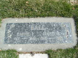
Lloyd Hudspeth Ball
| Birth | : | 5 Jul 1915 Chelan County, Washington, USA |
| Death | : | 23 Sep 1983 Entiat, Chelan County, Washington, USA |
| Burial | : | Pond Cemetery, Lyman, Grafton County, USA |
| Coordinate | : | 44.2671800, -71.9093700 |
| Plot | : | Row 17, Street Block 3 Alley 9, Lot 2 |
| Inscription | : | Carrie I Ball |
| Description | : | Chelan – Lloyd Hudspeth Ball, 68, of Chelan, died Friday near Entiat, as a result of injuries suffered in a one-car accident. He was born July 5, 1915, on the south side of Badger Mountain at the family homestead. He attended Beaver Creek School on Badger Mountain and later moved to Wenatchee with his family. In 1936, he graduated from Wenatchee High School and later that year started work with the Great Northern Railroad which later became Burlington Northern. On March 17, 1954, he was married to Carrie Felker at Coeur d'Alene, Idaho. Later they moved to Klamath Falls, Ore.,... Read More |
frequently asked questions (FAQ):
-
Where is Lloyd Hudspeth Ball's memorial?
Lloyd Hudspeth Ball's memorial is located at: Pond Cemetery, Lyman, Grafton County, USA.
-
When did Lloyd Hudspeth Ball death?
Lloyd Hudspeth Ball death on 23 Sep 1983 in Entiat, Chelan County, Washington, USA
-
Where are the coordinates of the Lloyd Hudspeth Ball's memorial?
Latitude: 44.2671800
Longitude: -71.9093700
Family Members:
Parent
Spouse
Siblings
Flowers:


Nearby Cemetories:
1. Pond Cemetery
Lyman, Grafton County, USA
Coordinate: 44.2671800, -71.9093700
2. Center Cemetery
Lyman, Grafton County, USA
Coordinate: 44.2672200, -71.9381400
3. Parker Hill Cemetery
Lyman, Grafton County, USA
Coordinate: 44.2582400, -71.9458800
4. Salmon Hole Cemetery
Lisbon, Grafton County, USA
Coordinate: 44.2359600, -71.8848200
5. Grove Hill Cemetery
Lisbon, Grafton County, USA
Coordinate: 44.2108002, -71.9094009
6. Moulton Hill Cemetery
Lyman, Grafton County, USA
Coordinate: 44.2457400, -71.9862900
7. West Littleton Cemetery
Littleton, Grafton County, USA
Coordinate: 44.3319016, -71.9199982
8. Pattenville Cemetery (Defunct)
Littleton, Grafton County, USA
Coordinate: 44.3310320, -71.8624310
9. Pettyboro District Cemetery
Pettyboro, Grafton County, USA
Coordinate: 44.2038310, -71.9620880
10. North Monroe Cemetery
Monroe, Grafton County, USA
Coordinate: 44.3067680, -71.9998780
11. Adams-Pfaelzer Cemetery
Littleton, Grafton County, USA
Coordinate: 44.3185210, -71.8283880
12. Riverside Cemetery
Waterford, Caledonia County, USA
Coordinate: 44.3456001, -71.8897018
13. Lower Waterford Cemetery
Waterford, Caledonia County, USA
Coordinate: 44.3474998, -71.9186020
14. Ammonoosuc Meadows Cemetery
Littleton, Grafton County, USA
Coordinate: 44.3013992, -71.8043976
15. Upper Smith Road Cemetery
Bath, Grafton County, USA
Coordinate: 44.2202780, -72.0075000
16. Sunnyside Cemetery
Sugar Hill, Grafton County, USA
Coordinate: 44.2130300, -71.8061600
17. Saint Rose of Lima New Catholic Cemetery
Littleton, Grafton County, USA
Coordinate: 44.3130989, -71.7949982
18. Landaff Center Cemetery
Landaff, Grafton County, USA
Coordinate: 44.1739860, -71.8847040
19. Glenwood Cemetery
Littleton, Grafton County, USA
Coordinate: 44.3116100, -71.7901400
20. Monroe Village Cemetery
Monroe, Grafton County, USA
Coordinate: 44.2558400, -72.0427900
21. West Waterford Cemetery
Waterford, Caledonia County, USA
Coordinate: 44.3604900, -71.9518300
22. Noyes Cemetery
Landaff, Grafton County, USA
Coordinate: 44.1830560, -71.8286110
23. Pleasant View Cemetery
Barnet, Caledonia County, USA
Coordinate: 44.2980200, -72.0469500
24. Eli Wallace Horse Cemetery
Littleton, Grafton County, USA
Coordinate: 44.2981300, -71.7714081