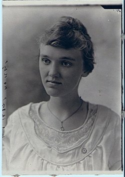
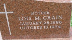
Lois Myrtle Smith Crain
| Birth | : | 28 Jan 1896 Elk Point, Union County, South Dakota, USA |
| Death | : | 13 Oct 1974 Ponca, Dixon County, Nebraska, USA |
| Burial | : | McPherson Cemetery, Clyde, Sandusky County, USA |
| Coordinate | : | 41.3093987, -82.9681015 |
frequently asked questions (FAQ):
-
Where is Lois Myrtle Smith Crain's memorial?
Lois Myrtle Smith Crain's memorial is located at: McPherson Cemetery, Clyde, Sandusky County, USA.
-
When did Lois Myrtle Smith Crain death?
Lois Myrtle Smith Crain death on 13 Oct 1974 in Ponca, Dixon County, Nebraska, USA
-
Where are the coordinates of the Lois Myrtle Smith Crain's memorial?
Latitude: 41.3093987
Longitude: -82.9681015
Family Members:
Parent
Spouse
Siblings
Children
Flowers:
Nearby Cemetories:
1. Saint Marys Cemetery
Clyde, Sandusky County, USA
Coordinate: 41.3058900, -82.9807500
2. Ellsworth Cemetery
Clyde, Sandusky County, USA
Coordinate: 41.3293991, -82.9269028
3. Colwell Cemetery
Green Creek, Sandusky County, USA
Coordinate: 41.2700005, -82.9800034
4. Greenlawn Memory Gardens
Clyde, Sandusky County, USA
Coordinate: 41.3210983, -83.0196991
5. Bakertown Cemetery
Clyde, Sandusky County, USA
Coordinate: 41.2882996, -83.0149994
6. Gilbert Cemetery
Clyde, Sandusky County, USA
Coordinate: 41.2778015, -82.9186020
7. Wales Corners Cemetery
Clyde, Sandusky County, USA
Coordinate: 41.3166885, -82.9018860
8. Beeler Cemetery
Clyde, Sandusky County, USA
Coordinate: 41.3488998, -83.0171967
9. Lay Cemetery
Green Springs, Seneca County, USA
Coordinate: 41.2552986, -82.9816971
10. York Free Chapel Cemetery
York, Sandusky County, USA
Coordinate: 41.2803100, -82.8982300
11. Dana Cemetery
Green Creek, Sandusky County, USA
Coordinate: 41.3283005, -83.0535965
12. Fuller Cemetery
Townsend Township, Sandusky County, USA
Coordinate: 41.3655280, -82.9118770
13. Raymond Cemetery
Green Springs, Seneca County, USA
Coordinate: 41.2495130, -83.0197690
14. Schoch Cemetery
Riley Township, Sandusky County, USA
Coordinate: 41.3567750, -83.0412060
15. McCreery Farm Cemetery
Vickery, Sandusky County, USA
Coordinate: 41.3917594, -82.9823677
16. Mount Lebanon Cemetery
Ballville, Sandusky County, USA
Coordinate: 41.3157150, -83.0786190
17. Green Springs Cemetery
Green Springs, Sandusky County, USA
Coordinate: 41.2592800, -83.0566100
18. Parkhurst Cemetery
Clyde, Sandusky County, USA
Coordinate: 41.3561550, -82.8732740
19. Lathrop Cemetery
Riley Township, Sandusky County, USA
Coordinate: 41.3928301, -83.0110269
20. Avery Cemetery
Clyde, Sandusky County, USA
Coordinate: 41.3207290, -82.8499700
21. McGrady Family Cemetery
Fremont, Sandusky County, USA
Coordinate: 41.3038960, -83.0926150
22. Fireside Cemetery
Seneca County, USA
Coordinate: 41.2270000, -82.9072100
23. Faust Cemetery
Riley Township, Sandusky County, USA
Coordinate: 41.3778000, -83.0599976
24. Union Cemetery
Seneca County, USA
Coordinate: 41.2118988, -82.9710999


