
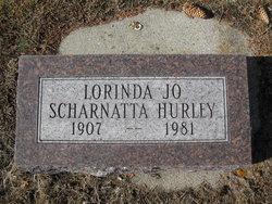
Lorinda Jo Carter Hurley
| Birth | : | 18 Nov 1907 Owatonna, Steele County, Minnesota, USA |
| Death | : | 30 Dec 1981 Butte, Silver Bow County, Montana, USA |
| Burial | : | R V Mike Ramsay Memorial Cemetery, Snowflake, Navajo County, USA |
| Coordinate | : | 34.5044000, -110.0869000 |
| Plot | : | Perpetual Care 3 |
| Description | : | The Missoulian Missoula, Montana January 6, 1982 Deer Lodge- Lorina Jo Hurley, 74, Anaconda, died December 30 in a Butte hospital. She was born November 18, 1907, to Roy and Hattie Carter in Owatonna, Minnesota. She received her education in Trossachs, Saskatchewan. She moved to Whitetail where she married Edward Scharnatta. He preceded her in death. In 1940 she moved to Galen where she was employed as a dietician at the state hospital. She married Charlie Hurley in 1947, and worked at the Welch's Truck stop in Garrison.... Read More |
frequently asked questions (FAQ):
-
Where is Lorinda Jo Carter Hurley's memorial?
Lorinda Jo Carter Hurley's memorial is located at: R V Mike Ramsay Memorial Cemetery, Snowflake, Navajo County, USA.
-
When did Lorinda Jo Carter Hurley death?
Lorinda Jo Carter Hurley death on 30 Dec 1981 in Butte, Silver Bow County, Montana, USA
-
Where are the coordinates of the Lorinda Jo Carter Hurley's memorial?
Latitude: 34.5044000
Longitude: -110.0869000
Family Members:
Spouse

Children
Flowers:


Nearby Cemetories:
1. R V Mike Ramsay Memorial Cemetery
Snowflake, Navajo County, USA
Coordinate: 34.5044000, -110.0869000
2. Taylor Cemetery
Taylor, Navajo County, USA
Coordinate: 34.4644012, -110.0971985
3. Shumway Cemetery
Shumway, Navajo County, USA
Coordinate: 34.4077988, -110.0824966
4. Love Lake Ranch Cemetery
Shumway, Navajo County, USA
Coordinate: 34.3984820, -110.0192360
5. Burton Cemetery
Navajo County, USA
Coordinate: 34.3314800, -110.1494000
6. Frost Family Cemetery
Linden, Navajo County, USA
Coordinate: 34.2932816, -110.1576004
7. Clay Springs Cemetery
Clay Springs, Navajo County, USA
Coordinate: 34.3686500, -110.2988300
8. Adair Cemetery
Show Low, Navajo County, USA
Coordinate: 34.2688500, -110.0647300
9. Pinedale Cemetery
Pinedale, Navajo County, USA
Coordinate: 34.3068000, -110.2467000
10. Show Low Cemetery
Show Low, Navajo County, USA
Coordinate: 34.2576830, -110.0392330
11. Conklin Gravesite
Show Low, Navajo County, USA
Coordinate: 34.2551613, -110.0244522
12. Woodruff Cemetery
Woodruff, Navajo County, USA
Coordinate: 34.7775000, -110.0325000
13. Grant Roadside Gravesite
Aripine, Navajo County, USA
Coordinate: 34.4258995, -110.4132767
14. Ward Cemetery
Concho, Apache County, USA
Coordinate: 34.6233014, -109.7602670
15. Church Of Our Saviour Columbarium
Pinetop-Lakeside, Navajo County, USA
Coordinate: 34.1869800, -110.0050700
16. Lakeside Cemetery
Pinetop-Lakeside, Navajo County, USA
Coordinate: 34.1521930, -109.9895570
17. Erastus Cemetery
Concho, Apache County, USA
Coordinate: 34.4722300, -109.6242800
18. Seventh Day Adventist Mission Cemetery
Holbrook, Navajo County, USA
Coordinate: 34.8842400, -110.1906100
19. Concho Catholic Cemetery
Concho, Apache County, USA
Coordinate: 34.4870770, -109.6064540
20. Phipps Grave
Pinetop-Lakeside, Navajo County, USA
Coordinate: 34.1242300, -109.9310400
21. Saint Marys Angels Rest Columbarium
Pinetop-Lakeside, Navajo County, USA
Coordinate: 34.1228290, -109.9340080
22. Overgaard Baby Cemetery
Overgaard, Navajo County, USA
Coordinate: 34.4011000, -110.5582900
23. Pinetop Cemetery
Pinetop-Lakeside, Navajo County, USA
Coordinate: 34.1212380, -109.9319030
24. Holbrook Cemetery
Holbrook, Navajo County, USA
Coordinate: 34.9097600, -110.1572500