
| Birth | : | 9 Jul 1912 Sumner, Dawson County, Nebraska, USA |
| Death | : | 25 Jul 2004 York, York County, Nebraska, USA |
| Burial | : | Shawnee Mission Memory Gardens, Shawnee, Johnson County, USA |
| Coordinate | : | 38.9923210, -94.8573914 |
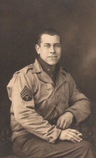
| Description | : | Lorna Radcliff Wiens, 92, of York, died at York General Hearthstone Care Center in York Sunday, July 25, 2004. Lorna was born in Sumner, Neb., to Samuel and Mary Kalous Radcliff. She graduated from Bradshaw High School in 1931 and married John T. (Jack) Wiens in 1934. Lorna was a member of the First United Methodist Church in York and was active in Ruth Circle. She also volunteered at Epworth Village. Lorna is survived by sons: Fred (Joleen) Wiens of Bay City, Texas, Frank (Kathy) Wiens of Bradshaw and Paul Wiens of Plano, Texas; daughters, Nancy (Darryl) Reed of San Jose, Calif., Margaret... Read More |
frequently asked questions (FAQ):
-
Where is Lorna Bell Radcliff Wiens's memorial?
Lorna Bell Radcliff Wiens's memorial is located at: Shawnee Mission Memory Gardens, Shawnee, Johnson County, USA.
-
When did Lorna Bell Radcliff Wiens death?
Lorna Bell Radcliff Wiens death on 25 Jul 2004 in York, York County, Nebraska, USA
-
Where are the coordinates of the Lorna Bell Radcliff Wiens's memorial?
Latitude: 38.9923210
Longitude: -94.8573914
Family Members:
Parent
Spouse

Siblings

Flowers:


Nearby Cemetories:
1. Shawnee Mission Memory Gardens
Shawnee, Johnson County, USA
Coordinate: 38.9923210, -94.8573914
2. Monticello Union Cemetery
Shawnee, Johnson County, USA
Coordinate: 38.9920311, -94.8617020
3. Old Monticello Cemetery
Shawnee, Johnson County, USA
Coordinate: 38.9951973, -94.8359833
4. Murphy Cemetery
Lenexa, Johnson County, USA
Coordinate: 38.9709282, -94.8816986
5. Boles Cemetery
Wilder, Johnson County, USA
Coordinate: 39.0292168, -94.8723450
6. Smith Burial Site
Lenexa, Johnson County, USA
Coordinate: 38.9319730, -94.8530820
7. Cedar Junction Cemetery
Cedar, Johnson County, USA
Coordinate: 38.9776800, -94.9339500
8. Lenape Cemetery
Lenape, Leavenworth County, USA
Coordinate: 39.0074997, -94.9602966
9. Lenexa Cemetery
Lenexa, Johnson County, USA
Coordinate: 38.9681015, -94.7416992
10. Saint Johns Catholic Cemetery
Lenexa, Johnson County, USA
Coordinate: 38.9666748, -94.7418594
11. Elm Grove Cemetery
Mahon, Leavenworth County, USA
Coordinate: 39.0582085, -94.9450150
12. Olathe Memorial Cemetery
Olathe, Johnson County, USA
Coordinate: 38.8961983, -94.8170013
13. Resurrection Catholic Cemetery
Lenexa, Johnson County, USA
Coordinate: 38.9763985, -94.7277985
14. DeSoto Cemetery
De Soto, Johnson County, USA
Coordinate: 38.9710999, -94.9882965
15. Pleasant View Cemetery
Shawnee, Johnson County, USA
Coordinate: 39.0192490, -94.7236862
16. Saint Joseph Catholic Cemetery
Shawnee, Johnson County, USA
Coordinate: 39.0167700, -94.7228800
17. Shawnee Cemetery
Shawnee, Johnson County, USA
Coordinate: 39.0181007, -94.7228012
18. Shawnee Indian Cemetery
Shawnee, Johnson County, USA
Coordinate: 39.0210800, -94.7123400
19. Campbell Cemetery
Shawnee, Johnson County, USA
Coordinate: 39.0294952, -94.7087479
20. Chance Cemetery
Linwood, Leavenworth County, USA
Coordinate: 39.0018997, -95.0156021
21. Mount Sidney Cemetery
Linwood, Leavenworth County, USA
Coordinate: 39.0017014, -95.0243988
22. Antioch Pioneer Cemetery
Merriam, Johnson County, USA
Coordinate: 38.9934807, -94.6868896
23. Glenwood Cemetery
Fairmount Township, Leavenworth County, USA
Coordinate: 39.1080017, -94.9449005
24. Sarcoxie Cemetery
Linwood, Leavenworth County, USA
Coordinate: 39.0410995, -95.0186005