
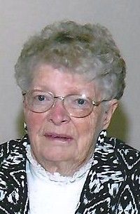

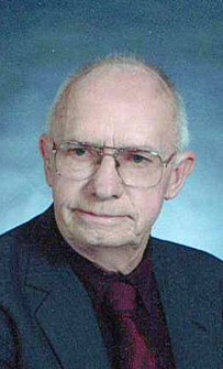
Lorna O. Tjarks Brown
| Birth | : | 10 Oct 1921 Clay County, Nebraska, USA |
| Death | : | 18 Jul 2012 Harvard, Clay County, Nebraska, USA |
| Burial | : | Glenvil Cemetery, Glenvil, Clay County, USA |
| Coordinate | : | 40.5088400, -98.2604700 |
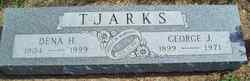
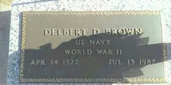
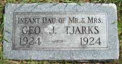
| Description | : | Lorna O. Brown, 90, died Wednesday, July 18, 2012, at the Harvard Rest Haven in Harvard, NE. Lorna was born October 10, 1921, to George and Dena (Kahman) Tjarks on the family farm near Glenvil, NE. Lorna received her education in Glenvil and graduated from Glenvil High School. On March 9, 1941, she married Delbert Brown in Hastings, NE. She spent the first few years of her marriage living in various places in the United States while her husband was in the military. After her husband's discharge, they settled in Hastings, NE before making their home in Harvard,... Read More |
frequently asked questions (FAQ):
-
Where is Lorna O. Tjarks Brown's memorial?
Lorna O. Tjarks Brown's memorial is located at: Glenvil Cemetery, Glenvil, Clay County, USA.
-
When did Lorna O. Tjarks Brown death?
Lorna O. Tjarks Brown death on 18 Jul 2012 in Harvard, Clay County, Nebraska, USA
-
Where are the coordinates of the Lorna O. Tjarks Brown's memorial?
Latitude: 40.5088400
Longitude: -98.2604700
Family Members:
Parent

Spouse
Siblings

Children


Nearby Cemetories:
1. Glenvil Cemetery
Glenvil, Clay County, USA
Coordinate: 40.5088400, -98.2604700
2. Saint Pauls Lutheran Cemetery
Adams County, USA
Coordinate: 40.5104530, -98.2872960
3. Glenville Union Cemetery
Glenvil, Clay County, USA
Coordinate: 40.5308980, -98.2052220
4. True Dutch Reformed Cemetery
Pauline, Adams County, USA
Coordinate: 40.4801300, -98.3160600
5. Scandinavian Lutheran Cemetery
Pauline, Adams County, USA
Coordinate: 40.4800700, -98.3162900
6. Fleming Farm Pet Cemetery
Hastings, Adams County, USA
Coordinate: 40.5547500, -98.3156100
7. Hanover Presbyterian Church Cemetery
Adams County, USA
Coordinate: 40.4802900, -98.3353850
8. South Inland Cemetery
Clay County, USA
Coordinate: 40.5682900, -98.2217500
9. Anandale Cemetery
Glenvil, Clay County, USA
Coordinate: 40.4661900, -98.1935300
10. Zion Cemetery
Clay County, USA
Coordinate: 40.5382996, -98.1643982
11. Old Inland Cemetery
Hastings, Adams County, USA
Coordinate: 40.5872300, -98.2974500
12. Inland Cemetery
Clay County, USA
Coordinate: 40.5964012, -98.2581024
13. Spring Ranch Cemetery
Clay County, USA
Coordinate: 40.4065100, -98.2484100
14. Kingston Cemetery
Adams County, USA
Coordinate: 40.4383250, -98.3695220
15. Mount Sinai Cemetery
Hastings, Adams County, USA
Coordinate: 40.5978012, -98.3647003
16. Parkview Cemetery
Hastings, Adams County, USA
Coordinate: 40.5985985, -98.3677979
17. Blue Valley Cemetery
Ayr, Adams County, USA
Coordinate: 40.4488983, -98.4011002
18. Saint Marks Episcopal Chapel Columbarium
Hastings, Adams County, USA
Coordinate: 40.5877800, -98.3922100
19. First Presbyterian Columbarium
Hastings, Adams County, USA
Coordinate: 40.5895900, -98.3913100
20. Crosier Monastery Cemetery
Hastings, Adams County, USA
Coordinate: 40.6014740, -98.3787920
21. Highland Cemetery
Hastings, Adams County, USA
Coordinate: 40.5983009, -98.3906021
22. Grace Methodist Church Memorial Columbarium
Hastings, Adams County, USA
Coordinate: 40.5937480, -98.4082340
23. Immanuel Lutheran Church Cemetery
Ayr, Adams County, USA
Coordinate: 40.5247870, -98.4583300
24. Saint Martin-Loucky Cemetery
Deweese, Clay County, USA
Coordinate: 40.3652496, -98.1948624