

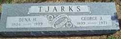
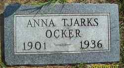
George Janssen Tjarks
| Birth | : | 11 Aug 1899 Glenvil, Clay County, Nebraska, USA |
| Death | : | 8 May 1971 |
| Burial | : | Reservoir Pines Cemetery, Clinton, Worcester County, USA |
| Coordinate | : | 42.4084900, -71.7109700 |
| Inscription | : | United In Marriage July 17, 1921 |
| Description | : | He was baptised as Gerd Janssen Tjarks on September 10, 1899. |
frequently asked questions (FAQ):
-
Where is George Janssen Tjarks's memorial?
George Janssen Tjarks's memorial is located at: Reservoir Pines Cemetery, Clinton, Worcester County, USA.
-
When did George Janssen Tjarks death?
George Janssen Tjarks death on 8 May 1971 in
-
Where are the coordinates of the George Janssen Tjarks's memorial?
Latitude: 42.4084900
Longitude: -71.7109700
Family Members:
Parent
Spouse
Siblings
Children


Flowers:


Nearby Cemetories:
1. Reservoir Pines Cemetery
Clinton, Worcester County, USA
Coordinate: 42.4084900, -71.7109700
2. Fairbank Burial Ground
Sterling, Worcester County, USA
Coordinate: 42.4152600, -71.7320000
3. Woodlawn Cemetery
Clinton, Worcester County, USA
Coordinate: 42.4185982, -71.6889038
4. Saint John's Cemetery
Lancaster, Worcester County, USA
Coordinate: 42.4328003, -71.6977997
5. Saint Lukes Cemetery
West Boylston, Worcester County, USA
Coordinate: 42.3833008, -71.7568970
6. Hillside Cemetery
Sterling, Worcester County, USA
Coordinate: 42.4410000, -71.7492570
7. Oak Hill Cemetery
Sterling, Worcester County, USA
Coordinate: 42.4417000, -71.7493973
8. Chocksett Burial Ground
Sterling, Worcester County, USA
Coordinate: 42.4377000, -71.7555400
9. Cookshire Cemetery
Sterling, Worcester County, USA
Coordinate: 42.4108500, -71.7734800
10. Middle Cemetery
Lancaster, Worcester County, USA
Coordinate: 42.4491997, -71.6757965
11. Old Common Burial Ground
Lancaster, Worcester County, USA
Coordinate: 42.4426700, -71.6645300
12. Old Settlers Burial Yard
Lancaster, Worcester County, USA
Coordinate: 42.4488754, -71.6742706
13. Thayer Cemetery
Lancaster, Worcester County, USA
Coordinate: 42.4578500, -71.7024400
14. Eastwood Cemetery
Lancaster, Worcester County, USA
Coordinate: 42.4417000, -71.6528015
15. Pine Grove Cemetery
Boylston, Worcester County, USA
Coordinate: 42.3582993, -71.7431030
16. West Cemetery
Sterling, Worcester County, USA
Coordinate: 42.4514100, -71.7651400
17. Old Burial Ground
Boylston, Worcester County, USA
Coordinate: 42.3515700, -71.7355300
18. Old Burying Ground
Berlin, Worcester County, USA
Coordinate: 42.3811646, -71.6375351
19. Legg Cemetery
Sterling, Worcester County, USA
Coordinate: 42.4070020, -71.7986150
20. North Cemetery
Berlin, Worcester County, USA
Coordinate: 42.4037000, -71.6225100
21. Old Fry Burying Ground
Bolton, Worcester County, USA
Coordinate: 42.4077300, -71.6209900
22. High Plains Cemetery
West Boylston, Worcester County, USA
Coordinate: 42.3889008, -71.7972031
23. Beaman Cemetery
West Boylston, Worcester County, USA
Coordinate: 42.3649590, -71.7803600
24. Mount Vernon Cemetery
West Boylston, Worcester County, USA
Coordinate: 42.3634650, -71.7804030