
| Birth | : | 3 Jul 1888 Johnson County, Iowa, USA |
| Death | : | 16 Feb 1920 Johnson County, Iowa, USA |
| Burial | : | Sharon Cemetery, Johnson County, USA |
| Coordinate | : | 41.5402000, -91.6370000 |
| Inscription | : | Daughter of Adolphus Skinner and Mary Elizabeth Overholser Ford |
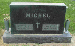
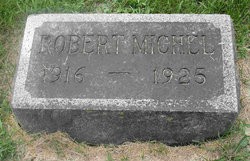
| Description | : | Husband Lester V Michel Daughter- Beulah Elizabeth Michael 3 June 1914 -Oct 1984. Buried at Fairmount Cemetery, Davenport, IA Son Robert P Michael. 1916 - 1925. Buried with father at Saint Stanislaus Cemetery in Hills, IA Contributor: Vicki Harris (49540117) Daughter-Norma E, after the death of her mother, she was adopted by her mother's sister and husband, Dr. Charles G. Tilden and Grace Ford Tildren. |
frequently asked questions (FAQ):
-
Where is Lottie B Ford Micheal's memorial?
Lottie B Ford Micheal's memorial is located at: Sharon Cemetery, Johnson County, USA.
-
When did Lottie B Ford Micheal death?
Lottie B Ford Micheal death on 16 Feb 1920 in Johnson County, Iowa, USA
-
Where are the coordinates of the Lottie B Ford Micheal's memorial?
Latitude: 41.5402000
Longitude: -91.6370000
Family Members:
Parent

Spouse
Siblings
Children
Flowers:


Nearby Cemetories:
1. Sharon Cemetery
Johnson County, USA
Coordinate: 41.5402000, -91.6370000
2. Sharon Center Cemetery
Johnson County, USA
Coordinate: 41.5543000, -91.6555000
3. Saint John Lutheran Cemetery
Sharon Center, Johnson County, USA
Coordinate: 41.5542000, -91.6678000
4. Yoder Family Cemetery
Sharon Center, Johnson County, USA
Coordinate: 41.5666832, -91.6460017
5. Fairview Mennonite Cemetery
Johnson County, USA
Coordinate: 41.5396000, -91.6751000
6. Saint Stanislaus Cemetery
Iowa City, Johnson County, USA
Coordinate: 41.5377000, -91.5960000
7. John Helmuth Cemetery
Sharon Center, Johnson County, USA
Coordinate: 41.5583870, -91.6764660
8. Peter Miller Cemetery
Johnson County, USA
Coordinate: 41.5214005, -91.6813965
9. Mentzer Cemetery
Johnson County, USA
Coordinate: 41.5574989, -91.5888977
10. Eash Cemetery
Johnson County, USA
Coordinate: 41.5800018, -91.6519012
11. North Gingerich Sharon Cemetery
Johnson County, USA
Coordinate: 41.5553017, -91.7024994
12. Middleburg Cemetery
Kalona, Washington County, USA
Coordinate: 41.4907990, -91.6613998
13. East Union Mennonite Cemetery
Sharon Center, Johnson County, USA
Coordinate: 41.5258179, -91.7049484
14. Saint Vincent Cemetery
Riverside, Washington County, USA
Coordinate: 41.4874992, -91.6188965
15. Sharon Bethel Cemetery
Williamstown, Johnson County, USA
Coordinate: 41.5558000, -91.7086000
16. Moses P Miller Cemetery
Kalona, Washington County, USA
Coordinate: 41.4929610, -91.6960140
17. Mount Olivet Cemetery
Riverside, Washington County, USA
Coordinate: 41.4864006, -91.5802994
18. Riverside Cemetery
Riverside, Washington County, USA
Coordinate: 41.4869003, -91.5785980
19. Sharon Hill Cemetery
Kalona, Washington County, USA
Coordinate: 41.4928017, -91.7071991
20. Hummer Cemetery
Johnson County, USA
Coordinate: 41.5974998, -91.6941986
21. South Gingerich Mennonite Cemetery
Kalona, Washington County, USA
Coordinate: 41.5076294, -91.7227936
22. Earhart Cemetery
Hills, Johnson County, USA
Coordinate: 41.5547300, -91.5424800
23. Haven Cemetery
Johnson County, USA
Coordinate: 41.5558080, -91.7320500
24. Snider Cemetery
Kalona, Washington County, USA
Coordinate: 41.4997386, -91.7196131