
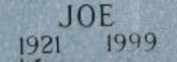

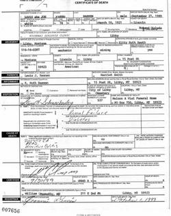

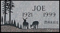
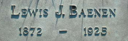
Louis Joseph Baenen
| Birth | : | 18 Mar 1921 Libby, Lincoln County, Montana, USA |
| Death | : | 27 Sep 1999 Libby, Lincoln County, Montana, USA |
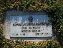
| Burial | : | Salem United Methodist Church Cemetery, Washburn, Rutherford County, USA |
| Coordinate | : | 35.4000015, -81.7985992 |
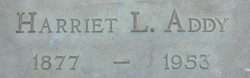
| Description | : | COX US NAVY WORLD WAR II Joe Baenen Louis Joe Baenen, 78, of Libby, died of heart failure Monday morning, Sept. 27, 1999, while undergoing his regular dialysis treatment at St. John's Lutheran Hospital. He had been in precarious health for many years but never let it interfere with his love for Montana and outdoor sports. Joe was born on March 18, 1921, in the old Baxter Hospital in Libby. A few days earlier his father Lew Baenen brought his mother Hattie by rowboat across the Kootenai River from Jennings for the trip to the hospital. When Joe was... Read More |
frequently asked questions (FAQ):
-
Where is Louis Joseph Baenen's memorial?
Louis Joseph Baenen's memorial is located at: Salem United Methodist Church Cemetery, Washburn, Rutherford County, USA.
-
When did Louis Joseph Baenen death?
Louis Joseph Baenen death on 27 Sep 1999 in Libby, Lincoln County, Montana, USA
-
Where are the coordinates of the Louis Joseph Baenen's memorial?
Latitude: 35.4000015
Longitude: -81.7985992
Family Members:
Parent
Spouse
Siblings

Flowers:

Left by Anonymous on 20 Jun 2006

Left by Anonymous on 05 Mar 2009

World War II Veteran
Left by Anonymous on 04 May 2015

US NAVY * WORLD WAR II
Left by Anonymous on 09 Jul 2015

Left by Anonymous on 24 Apr 2017

US NAVY WORLD WAR II
Left by Anonymous on 01 Dec 2018

US NAVY WORLD WAR II
Left by Anonymous on 01 Dec 2018

Left by Anonymous on 16 Feb 2021


Nearby Cemetories:
1. Salem United Methodist Church Cemetery
Washburn, Rutherford County, USA
Coordinate: 35.4000015, -81.7985992
2. Cherry Mountain Freewill Baptist Cemetery
Washburn, Rutherford County, USA
Coordinate: 35.3929060, -81.7902790
3. Green-Davis-Melton Cemetery
Rutherford County, USA
Coordinate: 35.3782930, -81.7928500
4. Hollifield Family Cemetery
Bostic, Rutherford County, USA
Coordinate: 35.4203956, -81.8117291
5. Mountain View Baptist Church Cemetery
Bostic, Rutherford County, USA
Coordinate: 35.4227630, -81.8080460
6. Walls Baptist Church Cemetery
Bostic, Rutherford County, USA
Coordinate: 35.3843141, -81.7757392
7. Wells Family Cemetery
Bostic, Rutherford County, USA
Coordinate: 35.3832400, -81.7757300
8. Cansler Cemetery
Sunshine, Rutherford County, USA
Coordinate: 35.4082600, -81.8350400
9. Sunshine United Methodist Church Cemetery
Bostic, Rutherford County, USA
Coordinate: 35.4286930, -81.8132680
10. Robertson Creek Freewill Baptist Cemetery
Bostic, Rutherford County, USA
Coordinate: 35.3937840, -81.8465540
11. New Vernon Baptist Cemetery
Bostic, Rutherford County, USA
Coordinate: 35.3958320, -81.8497430
12. Corinth Baptist Church Cemetery
Ellenboro, Rutherford County, USA
Coordinate: 35.3563900, -81.7971670
13. Mount Lebanon Cemetery
Rutherford County, USA
Coordinate: 35.4319000, -81.8414001
14. Sweezy-Murray Family Cemetery
Rutherford County, USA
Coordinate: 35.4432090, -81.7671363
15. Wilson Baptist Cemetery
Forest City, Rutherford County, USA
Coordinate: 35.4257164, -81.8531723
16. Cedar Grove United Methodist Church Cemetery
Rutherford County, USA
Coordinate: 35.4506110, -81.8097540
17. Duggar Freeman Cemetery
Rutherford County, USA
Coordinate: 35.4247780, -81.8585810
18. Hopewell Community Cemetery
Ellenboro, Rutherford County, USA
Coordinate: 35.3821440, -81.7343430
19. Concord Baptist Church Cemetery
Bostic, Rutherford County, USA
Coordinate: 35.3482000, -81.8227690
20. Ross Hill Baptist Church Cemetery
Bostic, Rutherford County, USA
Coordinate: 35.4575280, -81.7922220
21. Mount Harmony Baptist Church Cemetery
Bostic, Rutherford County, USA
Coordinate: 35.4588380, -81.7996940
22. Piney Mountain Baptist Cemetery
Ellenboro, Rutherford County, USA
Coordinate: 35.3454310, -81.7706050
23. Bostic Baptist Cemetery
Bostic, Rutherford County, USA
Coordinate: 35.3489370, -81.8371580
24. Elizabeth Edwards Gravesite
Ellenboro, Rutherford County, USA
Coordinate: 35.3567930, -81.7468030