Louisa Jane Baker Means
| Birth | : | Jun 1840 Illinois, USA |
| Death | : | 6 Apr 1912 Cherryvale, Montgomery County, Kansas, USA |
| Burial | : | Central Burying Ground, Boston, Suffolk County, USA |
| Coordinate | : | 42.3526300, -71.0659500 |
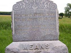
| Description | : | ************************** On July 10, 1857 Louisa Jane Baker married the widower William Carroll Means in Montgomery County, Iowa. She died at the home of her daughter, Mrs. J.H. Ward (Montie K Ward)of Cherryvale, Kansas on April 6, 1912. *research by Lila Cole ************************** My first Cousin 4 X Removed, daughter of James Baker and Mary Ann Prater she was born in Illinois, her Father died in abt. 1845 in Missouri, and her Mother died in Kansas while visiting Louisa's brother Baxter Prater Baker. *contributed by Donna Sutiff ************************** Thanks to Orlene Bedigrew for the death information from the obituary. |
frequently asked questions (FAQ):
-
Where is Louisa Jane Baker Means's memorial?
Louisa Jane Baker Means's memorial is located at: Central Burying Ground, Boston, Suffolk County, USA.
-
When did Louisa Jane Baker Means death?
Louisa Jane Baker Means death on 6 Apr 1912 in Cherryvale, Montgomery County, Kansas, USA
-
Where are the coordinates of the Louisa Jane Baker Means's memorial?
Latitude: 42.3526300
Longitude: -71.0659500
Family Members:
Parent
Spouse
Siblings
Children
Flowers:
Nearby Cemetories:
1. Central Burying Ground
Boston, Suffolk County, USA
Coordinate: 42.3526300, -71.0659500
2. Cocoanut Grove Fire Memorial
Boston, Suffolk County, USA
Coordinate: 42.3499600, -71.0681900
3. Trinity Church Tombs (Defunct)
Boston, Suffolk County, USA
Coordinate: 42.3549300, -71.0597500
4. Granary Burying Ground
Boston, Suffolk County, USA
Coordinate: 42.3572400, -71.0613500
5. Kings Chapel Burying Ground
Boston, Suffolk County, USA
Coordinate: 42.3583340, -71.0600370
6. Old South Church
Boston, Suffolk County, USA
Coordinate: 42.3500500, -71.0779000
7. Cathedral of the Holy Cross Crypt
Boston, Suffolk County, USA
Coordinate: 42.3408200, -71.0697400
8. South Burying Ground
Boston, Suffolk County, USA
Coordinate: 42.3382600, -71.0741000
9. Copp's Hill Burying Ground
Boston, Suffolk County, USA
Coordinate: 42.3670100, -71.0560800
10. Christ Church Cemetery
Boston, Suffolk County, USA
Coordinate: 42.3664900, -71.0545200
11. Saint Matthews Cemetery (Defunct)
South Boston, Suffolk County, USA
Coordinate: 42.3379940, -71.0497180
12. Charlestown Revolutionary War Memorial
Charlestown, Suffolk County, USA
Coordinate: 42.3745800, -71.0601800
13. Saint Augustine Cemetery
South Boston, Suffolk County, USA
Coordinate: 42.3339900, -71.0491800
14. Eliot Burying Ground
Roxbury, Suffolk County, USA
Coordinate: 42.3318890, -71.0811970
15. Bunker Hill Monument
Charlestown, Suffolk County, USA
Coordinate: 42.3762360, -71.0607300
16. Phipps Street Burying Ground
Charlestown, Suffolk County, USA
Coordinate: 42.3766300, -71.0673000
17. Bunker Hill Burying Ground
Charlestown, Suffolk County, USA
Coordinate: 42.3789300, -71.0621200
18. South Boston Farm Cemetery (Defunct)
South Boston, Suffolk County, USA
Coordinate: 42.3388510, -71.0326710
19. Warren Cemetery (Defunct)
Boston, Suffolk County, USA
Coordinate: 42.3269700, -71.0825500
20. Saint Francis de Sales Cemetery
Charlestown, Suffolk County, USA
Coordinate: 42.3815420, -71.0658620
21. Hawes Burying Ground
South Boston, Suffolk County, USA
Coordinate: 42.3340607, -71.0345078
22. Union Cemetery
South Boston, Suffolk County, USA
Coordinate: 42.3340440, -71.0344730
23. Warren Anatomical Museum
Boston, Suffolk County, USA
Coordinate: 42.3351300, -71.1036100
24. Saint Margaret's Convent Columbarium
Roxbury, Suffolk County, USA
Coordinate: 42.3260000, -71.0940700


