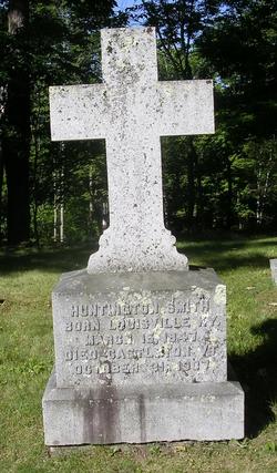
| Birth | : | 1 Aug 1824 Springfield, Washington County, Kentucky, USA |
| Death | : | 22 Jan 1899 Durham, Strafford County, New Hampshire, USA |
| Burial | : | Cliff Cemetery, Cannelton, Perry County, USA |
| Coordinate | : | 37.9122270, -86.7352520 |
| Description | : | Louise is the daughter of Christopher Rudd (1791-1840) and Anna Benoist Palmer (1795-1884). She married Hamilton Smith on 20 May 1846 in Louisville, Jefferson County, Kentucky. |
frequently asked questions (FAQ):
-
Where is Louise Elizabeth Rudd Smith's memorial?
Louise Elizabeth Rudd Smith's memorial is located at: Cliff Cemetery, Cannelton, Perry County, USA.
-
When did Louise Elizabeth Rudd Smith death?
Louise Elizabeth Rudd Smith death on 22 Jan 1899 in Durham, Strafford County, New Hampshire, USA
-
Where are the coordinates of the Louise Elizabeth Rudd Smith's memorial?
Latitude: 37.9122270
Longitude: -86.7352520
Family Members:
Spouse
Children
Flowers:
Nearby Cemetories:
1. Cliff Cemetery
Cannelton, Perry County, USA
Coordinate: 37.9122270, -86.7352520
2. New Cliff Cemetery
Cannelton, Perry County, USA
Coordinate: 37.9131760, -86.7359460
3. Saint Michaels Cemetery
Cannelton, Perry County, USA
Coordinate: 37.9164009, -86.7332993
4. First Cannelton Cemetery
Cannelton, Perry County, USA
Coordinate: 37.9099030, -86.7417420
5. Fournier Cemetery
Cannelton, Perry County, USA
Coordinate: 37.9118570, -86.7272720
6. Walnut Grove Cemetery
Tell City, Perry County, USA
Coordinate: 37.9275720, -86.7412670
7. Hawesville Cemetery
Hawesville, Hancock County, USA
Coordinate: 37.8982100, -86.7546200
8. Cavender Cemetery
Cannelton, Perry County, USA
Coordinate: 37.8978090, -86.7146910
9. Saint Paul Cemetery
Hawesville, Hancock County, USA
Coordinate: 37.8969780, -86.7592740
10. Ayres Cemetery
Hawesville, Hancock County, USA
Coordinate: 37.9015700, -86.7778000
11. Mount Calvary Cemetery
Hawesville, Hancock County, USA
Coordinate: 37.9001300, -86.7774300
12. Bolin Cemetery
Cannelton, Perry County, USA
Coordinate: 37.9384820, -86.7049380
13. Serenity Hills Cemetery
Hawesville, Hancock County, USA
Coordinate: 37.9007600, -86.7781890
14. Chestnut Grove Cemetery
Tell City, Perry County, USA
Coordinate: 37.9475250, -86.7246094
15. Mosby Cemetery
Tell City, Perry County, USA
Coordinate: 37.9597630, -86.7572160
16. Thresher Cemetery
Troy Township, Perry County, USA
Coordinate: 37.9567440, -86.7036900
17. Mason Cemetery
Cannelton, Perry County, USA
Coordinate: 37.9168130, -86.6696620
18. Greenwood Cemetery
Tell City, Perry County, USA
Coordinate: 37.9644012, -86.7506027
19. Buxton Cemetery
Hancock County, USA
Coordinate: 37.9021850, -86.8021020
20. Beauchamp Family Cemetery #8
Lewisport, Hancock County, USA
Coordinate: 37.9242760, -86.8043390
21. Powell Cemetery
Tell City, Perry County, USA
Coordinate: 37.9678460, -86.7269160
22. Fairview Cemetery
Hancock County, USA
Coordinate: 37.8885994, -86.6669006
23. Saint Marys Catholic Cemetery
Tell City, Perry County, USA
Coordinate: 37.9664307, -86.7682190
24. Sterrett Cemetery
Hancock County, USA
Coordinate: 37.8878070, -86.6601460


