
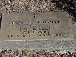

Lowell L. Shawler
| Birth | : | 15 Feb 1893 Iowa, USA |
| Death | : | 20 Oct 1964 USA |
| Burial | : | St. Mary's Churchyard, Saxlingham Nethergate, South Norfolk District, England |
| Coordinate | : | 52.5268910, 1.2880390 |
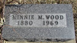
| Description | : | Lowell Shawler, Clearfield, Dies Lowell Shawler, 71 a resident of Clearfield for most of his life, died at the Veterans, hospital in Omaha, Nebr., Tuesday. Funeral services will be held at 2 p.m.Saturday at the Varner-Crew funeral home at Clearfield. Rev. Herbert Phillips pastor of the Clearfield Methodist Church will officiate. Burial will be in the Clearfield cemetery where military grave side services will be held. His family will be at the funeral home from 7:30 to 8:30 p. m. Friday. Mr. Shawler is survived by a sister, Mrs. Minnie Wood, who is in the Clearview nursing home in... Read More |
frequently asked questions (FAQ):
-
Where is Lowell L. Shawler's memorial?
Lowell L. Shawler's memorial is located at: St. Mary's Churchyard, Saxlingham Nethergate, South Norfolk District, England.
-
When did Lowell L. Shawler death?
Lowell L. Shawler death on 20 Oct 1964 in USA
-
Where are the coordinates of the Lowell L. Shawler's memorial?
Latitude: 52.5268910
Longitude: 1.2880390
Family Members:
Parent
Siblings
Flowers:


Nearby Cemetories:
1. St Mary Churchyard
Shotesham, South Norfolk District, England
Coordinate: 52.5411110, 1.2985880
2. St Mary's Churchyard
Newton Flotman, South Norfolk District, England
Coordinate: 52.5393520, 1.2617220
3. All Saints Church
Shotesham, South Norfolk District, England
Coordinate: 52.5428610, 1.3120560
4. St Margaret Churchyard
Hempnall, South Norfolk District, England
Coordinate: 52.5018500, 1.3004810
5. St Catherine Churchyard
Fritton, Great Yarmouth Borough, England
Coordinate: 52.4919750, 1.2796600
6. St Michael And All Saint's
Flordon, South Norfolk District, England
Coordinate: 52.5294700, 1.2261400
7. Saint John the Baptist Churchyard
Morningthorpe, South Norfolk District, England
Coordinate: 52.4859170, 1.2654150
8. St Remigius Churchyard
Dunston, South Norfolk District, England
Coordinate: 52.5722420, 1.2872510
9. St Mary Churchyard
Howe, South Norfolk District, England
Coordinate: 52.5497970, 1.3541770
10. St. Mary Magdalen Churchyard
Mulbarton, South Norfolk District, England
Coordinate: 52.5638930, 1.2360530
11. St. Margaret Churchyard
Hapton, South Norfolk District, England
Coordinate: 52.5244110, 1.2066410
12. St Nicholas Churchyard
Bracon Ash, South Norfolk District, England
Coordinate: 52.5559000, 1.2137000
13. All Saints Churchyard
Poringland, South Norfolk District, England
Coordinate: 52.5657160, 1.3496310
14. St Mary's Churchyard
Long Stratton, South Norfolk District, England
Coordinate: 52.4840800, 1.2339000
15. Saint Edmund Churchyard
Caistor St Edmund, South Norfolk District, England
Coordinate: 52.5826350, 1.2936850
16. St. Mary's Churchyard
Shelton, South Norfolk District, England
Coordinate: 52.4720940, 1.2686120
17. Long Stratton Congregational Churchyard
Long Stratton, South Norfolk District, England
Coordinate: 52.4818890, 1.2324460
18. St Margaret's Churchyard
Kirstead, South Norfolk District, England
Coordinate: 52.5358860, 1.3840860
19. Saint Andrews Churchyard
Bedingham, South Norfolk District, England
Coordinate: 52.4902500, 1.3643180
20. St Peters Churchyard
Brooke, South Norfolk District, England
Coordinate: 52.5452560, 1.3814930
21. All Saints Churchyard
Hethel, South Norfolk District, England
Coordinate: 52.5578530, 1.2014560
22. St Mary Churchyard
East Carleton, South Norfolk District, England
Coordinate: 52.5726700, 1.2153470
23. Saint Margaret's Churchyard
Hardwick, South Norfolk District, England
Coordinate: 52.4632800, 1.2712440
24. St Andrew Churchyard
Framingham Earl, South Norfolk District, England
Coordinate: 52.5748560, 1.3596480