
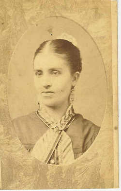
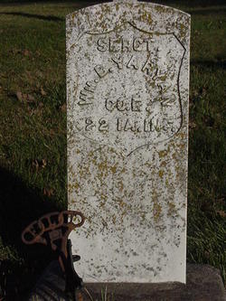
Harriet Wiard Yaryan
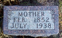
| Birth | : | 1 Feb 1852 Illinois, USA |
| Death | : | 15 Jul 1938 Clearfield, Taylor County, Iowa, USA |
| Burial | : | Hastings Cemetery, Hastings, Mills County, USA |
| Coordinate | : | 41.0097008, -95.4993973 |
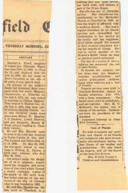
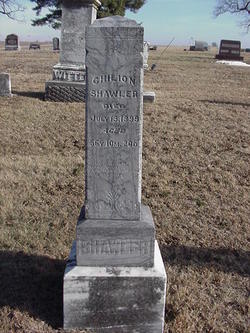
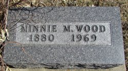
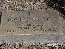
| Description | : | Harriet was the daughter of J. Millard Wiard/Weard and Charlotte Lesch. She married 1st to Chilion Shawler. He died in 1899. She married 2nd on May 28, 1903, to William Bedell Yaryan. Children of Harriet and Chilion: Minnie M. Shawler Wood (1880-1969) Lowell L. Shawler (1893-1964) Photo and obituary courtesy of Joyce Shawler. |
frequently asked questions (FAQ):
-
Where is Harriet Wiard Yaryan's memorial?
Harriet Wiard Yaryan's memorial is located at: Hastings Cemetery, Hastings, Mills County, USA.
-
When did Harriet Wiard Yaryan death?
Harriet Wiard Yaryan death on 15 Jul 1938 in Clearfield, Taylor County, Iowa, USA
-
Where are the coordinates of the Harriet Wiard Yaryan's memorial?
Latitude: 41.0097008
Longitude: -95.4993973
Family Members:
Spouse
Children
Flowers:


Nearby Cemetories:
1. Hastings Cemetery
Hastings, Mills County, USA
Coordinate: 41.0097008, -95.4993973
2. North Grove Cemetery
Hastings, Mills County, USA
Coordinate: 41.0161018, -95.4618988
3. South Grove Cemetery
Mills County, USA
Coordinate: 40.9775009, -95.4931030
4. Wearin Cemetery
Malvern, Mills County, USA
Coordinate: 41.0395000, -95.5313000
5. Parker Cemetery
White Cloud, Mills County, USA
Coordinate: 40.9737649, -95.5184363
6. Malvern Cemetery
Malvern, Mills County, USA
Coordinate: 40.9886017, -95.5785980
7. Cotten Cemetery
Mills County, USA
Coordinate: 41.0845000, -95.5167000
8. Emerson Cemetery
Emerson, Mills County, USA
Coordinate: 41.0325012, -95.4021988
9. East Liberty Cemetery
Malvern, Mills County, USA
Coordinate: 41.0592346, -95.6005020
10. Wesley Chapel Cemetery
Henderson, Mills County, USA
Coordinate: 41.1019249, -95.4987793
11. Saylers Farm Cemetery
Henderson, Mills County, USA
Coordinate: 41.1083300, -95.4919440
12. Lowens Cemetery
Garfield Township, Montgomery County, USA
Coordinate: 41.0527728, -95.3758292
13. Hillsdale Cemetery
Glenwood, Mills County, USA
Coordinate: 41.0097008, -95.6427994
14. Walnut Cemetery
Montgomery County, USA
Coordinate: 40.9519005, -95.3741989
15. David Farm Cemetery
West Township, Montgomery County, USA
Coordinate: 40.9249960, -95.3766593
16. Riverside Cemetery
Randolph, Fremont County, USA
Coordinate: 40.8806000, -95.5269012
17. Monroe Cemetery
Imogene, Fremont County, USA
Coordinate: 40.8880997, -95.4222031
18. Farm Creek Cemetery
Henderson, Mills County, USA
Coordinate: 41.1319008, -95.4186020
19. Mills County Farm Cemetery
Glenwood, Mills County, USA
Coordinate: 41.0417930, -95.6756530
20. Silver City Cemetery
Silver City, Mills County, USA
Coordinate: 41.1042442, -95.6380005
21. Randolph Cemetery
Randolph, Fremont County, USA
Coordinate: 40.8769493, -95.5695038
22. Fairview Cemetery
Tabor, Mills County, USA
Coordinate: 40.9453011, -95.6716995
23. Salem Cemetery
Red Oak, Montgomery County, USA
Coordinate: 40.9733009, -95.3088989
24. Bomar Family Cemetery
Mills County, USA
Coordinate: 41.0369400, -95.6941700