
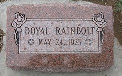
| Birth | : | 24 May 1923 |
| Death | : | 6 Dec 1993 |
| Burial | : | Rose Hill Cemetery, Rifle, Garfield County, USA |
| Coordinate | : | 39.5381012, -107.7742004 |
| Inscription | : | "Peace unto thee" Loyal W. Rainbolt Sr. May 24, 1923 Dec. 6, 1993 "Beloved husband of Wilma" Married Mar. 12, 1983 Back: "Loyal Rainbolt Loving father of Loyal W. "Hap" Jr. Vickie Ann |
| Description | : | NOT FOUND in the Rainbolt Genealogy Book : ************************************* 1930 Census : District 3, Coldwater, Comanche County, Kansas Page# 11 Individual# 38 ************************************* 1940 Census : NOT FOUND ************************************ Rifle, Garfield County, Colorado Social Security Death Index: 9 December 2009 ************************************* The Daily Sentinel 9 December 1993 Page# 10 Grand Junction, Colorado Loyal W. “Hap” Rainbolt of Rifle died of cancer Monday in St. Mary’s Hospital… He was 70 .. Visitation will be until 9 tonight in the Sowder Funeral Home Chapel .. Services will be at 10:00 AM Friday in the First... Read More |
frequently asked questions (FAQ):
-
Where is Loyal W. Rainbolt Sr.'s memorial?
Loyal W. Rainbolt Sr.'s memorial is located at: Rose Hill Cemetery, Rifle, Garfield County, USA.
-
When did Loyal W. Rainbolt Sr. death?
Loyal W. Rainbolt Sr. death on 6 Dec 1993 in
-
Where are the coordinates of the Loyal W. Rainbolt Sr.'s memorial?
Latitude: 39.5381012
Longitude: -107.7742004
Family Members:
Parent
Siblings
Flowers:


Nearby Cemetories:
1. Rose Hill Cemetery
Rifle, Garfield County, USA
Coordinate: 39.5381012, -107.7742004
2. Skyline Cemetery
Silt, Garfield County, USA
Coordinate: 39.5520060, -107.6575300
3. Rulison Cemetery
Rulison, Garfield County, USA
Coordinate: 39.4768000, -107.9357000
4. Union Divide Creek Cemetery
Silt, Garfield County, USA
Coordinate: 39.4508018, -107.6200027
5. Highland Cemetery
New Castle, Garfield County, USA
Coordinate: 39.5875015, -107.5192032
6. Battlement Cemetery
Parachute, Garfield County, USA
Coordinate: 39.4380989, -108.0291977
7. Russey-Hurlburt Cemetery
Parachute, Garfield County, USA
Coordinate: 39.4522018, -108.0575027
8. Blackman Ranch Cemetery
Collbran, Mesa County, USA
Coordinate: 39.2647420, -107.8554350
9. Clover Cemetery
Collbran, Mesa County, USA
Coordinate: 39.2550011, -107.9227982
10. Cedar Crest Cemetery
Collbran, Mesa County, USA
Coordinate: 39.2369003, -107.9589005
11. Farnum Holt Columbarium
Glenwood Springs, Garfield County, USA
Coordinate: 39.5469640, -107.3299900
12. Pioneer Cemetery
Glenwood Springs, Garfield County, USA
Coordinate: 39.5392000, -107.3192000
13. Rosebud Cemetery
Glenwood Springs, Garfield County, USA
Coordinate: 39.5168991, -107.3189011
14. Eagalite Cemetery
Plateau City, Mesa County, USA
Coordinate: 39.2228012, -107.9894028
15. DeBeque Cemetery
Mesa County, USA
Coordinate: 39.3374060, -108.2138900
16. Marion Cemetery
Garfield County, USA
Coordinate: 39.3689003, -107.3047028
17. Molina Cemetery
Molina, Mesa County, USA
Coordinate: 39.1886000, -108.0629000
18. Evergreen Cemetery
Carbondale, Garfield County, USA
Coordinate: 39.4077988, -107.2155991
19. Fisher Cemetery
Carbondale, Garfield County, USA
Coordinate: 39.4791985, -107.1911011
20. Mesa Cemetery
Mesa, Mesa County, USA
Coordinate: 39.1685982, -108.1188965
21. Hillcrest Cemetery
Carbondale, Garfield County, USA
Coordinate: 39.3922005, -107.1936035
22. Highland Cemetery
Meeker, Rio Blanco County, USA
Coordinate: 40.0311012, -107.9111023
23. Camp on White River Cemetery
Meeker, Rio Blanco County, USA
Coordinate: 40.0380100, -107.9131000
24. Black Sulphur Cemetery
Meeker, Rio Blanco County, USA
Coordinate: 39.8600800, -108.3109500