

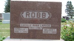
Lucille Gwendolyn Robb Larson
| Birth | : | 18 Dec 1911 Burchard, Pawnee County, Nebraska, USA |
| Death | : | 1 May 1967 Pawnee City, Pawnee County, Nebraska, USA |
| Burial | : | Pawnee City Cemetery, Pawnee City, Pawnee County, USA |
| Coordinate | : | 40.1109009, -96.1608810 |
| Description | : | Daughter of Walker Talmadge Robb & Stella Luella Martin Robb. Married to Richard Raymond Larson on Dec. 16, 1938 at East Side Lutheran Church in Sioux Falls, SD. MRS. LUCILLE LARSON Lucille Gwendolyn Robb Larson, daughter of Walker and Stella L. Robb, was born December 18, 1911, at Burchard, Nebraska. She attended school in Burchard and Pawnee City and earned her teaching certificate from Peru State Teachers' College. She taught school several years in the Summerfield, Mission Creek and Plum Creek districts. On October 10, 1938, Lucille was married to Richard R. Larson. She was a... Read More |
frequently asked questions (FAQ):
-
Where is Lucille Gwendolyn Robb Larson's memorial?
Lucille Gwendolyn Robb Larson's memorial is located at: Pawnee City Cemetery, Pawnee City, Pawnee County, USA.
-
When did Lucille Gwendolyn Robb Larson death?
Lucille Gwendolyn Robb Larson death on 1 May 1967 in Pawnee City, Pawnee County, Nebraska, USA
-
Where are the coordinates of the Lucille Gwendolyn Robb Larson's memorial?
Latitude: 40.1109009
Longitude: -96.1608810
Family Members:
Parent

Siblings


Flowers:


Nearby Cemetories:
1. Pawnee City Cemetery
Pawnee City, Pawnee County, USA
Coordinate: 40.1109009, -96.1608810
2. East Amish Cemetery
Table Rock, Pawnee County, USA
Coordinate: 40.1310000, -96.0854000
3. Evergreen Cemetery
Pawnee County, USA
Coordinate: 40.0485992, -96.1417007
4. Pleasant Valley Cemetery
Pawnee County, USA
Coordinate: 40.0299988, -96.1554794
5. Table Rock Cemetery
Table Rock, Pawnee County, USA
Coordinate: 40.1791400, -96.1037400
6. Prairie Star Pioneer Cemetery
Du Bois, Pawnee County, USA
Coordinate: 40.0293000, -96.1041000
7. Beranek Cemetery
Table Rock, Pawnee County, USA
Coordinate: 40.2042007, -96.1607971
8. Pleasant Ridge Cemetery
Du Bois, Pawnee County, USA
Coordinate: 40.0156000, -96.1494000
9. West Branch Cemetery
Pawnee County, USA
Coordinate: 40.0787940, -96.2797160
10. Saint Anthonys Cemetery
Steinauer, Pawnee County, USA
Coordinate: 40.2075005, -96.2189026
11. Johnson Creek Cemetery
Pawnee City, Pawnee County, USA
Coordinate: 40.0270000, -96.2465000
12. Clear Creek Cemetery
Table Rock, Pawnee County, USA
Coordinate: 40.2193985, -96.1391983
13. Bohemian Cemetery
Table Rock, Pawnee County, USA
Coordinate: 40.1786003, -96.0374985
14. Saint Peters Evangelican Cemetery
Du Bois, Pawnee County, USA
Coordinate: 40.0010000, -96.1095000
15. Dry Branch Pioneer Cemetery
Richardson County, USA
Coordinate: 40.1292000, -96.0100021
16. DuBois Cemetery
Du Bois, Pawnee County, USA
Coordinate: 40.0231018, -96.0488968
17. Bohemian Cemetery
Richardson County, USA
Coordinate: 40.1175003, -95.9955978
18. Saint Johns Cemetery
Table Rock, Pawnee County, USA
Coordinate: 40.2148000, -96.0657000
19. Salems Cemetery
Steinauer, Pawnee County, USA
Coordinate: 40.2166000, -96.2555000
20. McCaffrey Cemetery
Nemaha County, USA
Coordinate: 39.9827100, -96.1474500
21. Madden Cemetery
Axtell, Marshall County, USA
Coordinate: 39.9866800, -96.2490300
22. Friedens United Church of Christ Cemetery
Bern, Nemaha County, USA
Coordinate: 39.9929008, -96.0529480
23. Saint Peters Lutheran Church Cemetery
Steinauer, Pawnee County, USA
Coordinate: 40.2555000, -96.1801000
24. Cincinnati Cemetery
Du Bois, Pawnee County, USA
Coordinate: 40.0042000, -96.0274963