
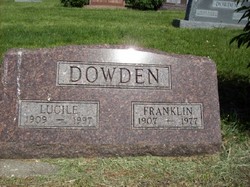
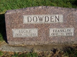
Lucille M Lawson Dowden
| Birth | : | 1 Jun 1909 Wilcox, Nodaway County, Missouri, USA |
| Death | : | 18 Jan 1996 Maryville, Nodaway County, Missouri, USA |
| Burial | : | St Peter Churchyard, Brafferton, Hambleton District, England |
| Coordinate | : | 54.1252600, -1.3337300 |
| Description | : | Lucile M. Dowden, 87, Maryville, died Saturday, Jan. 18, 1996, at St. Francis Hospital, Maryville. Born June 1, 1909, in Wilcox, Missouri, to Abijah and Mary Elizabeth Hooker Lawson, she was a homemaker. She married Earl "Franklin" Dowden, December 11, 1928, in Maryville. A resident of Maryville since 1950, Mrs. Dowden and her husband farmed in rural Maryville. She was a 1928 graduate of Harmony High School and a member of the First United Methodist Church, Maryville; the Mutual Improvement Circle, Maryville; and the Penelope Club of Maryville. Services were held at 10 a.m., Tuesday, Jan. 21, at Price Funeral Home Chapel, Maryville,... Read More |
frequently asked questions (FAQ):
-
Where is Lucille M Lawson Dowden's memorial?
Lucille M Lawson Dowden's memorial is located at: St Peter Churchyard, Brafferton, Hambleton District, England.
-
When did Lucille M Lawson Dowden death?
Lucille M Lawson Dowden death on 18 Jan 1996 in Maryville, Nodaway County, Missouri, USA
-
Where are the coordinates of the Lucille M Lawson Dowden's memorial?
Latitude: 54.1252600
Longitude: -1.3337300
Family Members:
Parent

Spouse
Siblings


Nearby Cemetories:
1. St Peter Churchyard
Brafferton, Hambleton District, England
Coordinate: 54.1252600, -1.3337300
2. St. Mary and All Saints Churchyard
Cundall, Harrogate Borough, England
Coordinate: 54.1518340, -1.3542490
3. St Mary Churchyard
Myton-on-Swale, Hambleton District, England
Coordinate: 54.0937940, -1.3300540
4. All Saints Churchyard
Kirby Hill, Harrogate Borough, England
Coordinate: 54.1116730, -1.4007950
5. St. Andrew's Churchyard
Aldborough, Harrogate Borough, England
Coordinate: 54.0921790, -1.3809300
6. Aldborough Cemetery
Aldborough, Harrogate Borough, England
Coordinate: 54.0887207, -1.3843854
7. St Mary Churchyard
Lower Dunsforth, Harrogate Borough, England
Coordinate: 54.0777130, -1.3241810
8. St James Churchyard
Boroughbridge, Harrogate Borough, England
Coordinate: 54.0929860, -1.3945270
9. St Cuthbert Churchyard
Sessay, Hambleton District, England
Coordinate: 54.1662400, -1.2906070
10. St Mary the Virgin Churchyard
Raskelf, Hambleton District, England
Coordinate: 54.1305760, -1.2520440
11. Boroughbridge Cemetery
Boroughbridge, Harrogate Borough, England
Coordinate: 54.0905100, -1.3975300
12. Dishforth Cemetery
Dishforth, Harrogate Borough, England
Coordinate: 54.1561350, -1.4115950
13. St John the Evangelist Churchyard
Dalton, Hambleton District, England
Coordinate: 54.1806400, -1.3341500
14. Topcliffe Cemetery
Topcliffe, Hambleton District, England
Coordinate: 54.1774200, -1.3846100
15. St Columba Churchyard
Topcliffe, Hambleton District, England
Coordinate: 54.1785070, -1.3892590
16. St Mary Churchyard
Roecliff, Harrogate Borough, England
Coordinate: 54.0883540, -1.4261620
17. St Stephen Churchyard
Aldwark, Hambleton District, England
Coordinate: 54.0640600, -1.2875000
18. St Mary Churchyard
Alne, Hambleton District, England
Coordinate: 54.0814400, -1.2438800
19. St Mary Magdalene Churchyard
Thormanby, Hambleton District, England
Coordinate: 54.1678900, -1.2420600
20. St Helen Churchyard
Skelton, Harrogate Borough, England
Coordinate: 54.1095070, -1.4489870
21. Christ the Consoler Churchyard
Skelton, Harrogate Borough, England
Coordinate: 54.1059760, -1.4508880
22. Marton-cum-Grafton Cemetery
Marton, Harrogate Borough, England
Coordinate: 54.0549100, -1.3647800
23. St Mary the Virgin Churchyard
Great Ouseburn, Harrogate Borough, England
Coordinate: 54.0488052, -1.3125230
24. St John the Baptist and All Saints Churchyard
Easingwold, Hambleton District, England
Coordinate: 54.1235320, -1.1973170