

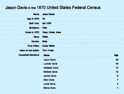
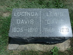
Lucinda Brown Davis
| Birth | : | Oct 1835 Ohio, USA |
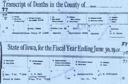
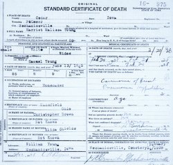
| Death | : | 1910 Cedar County, Iowa, USA |
| Burial | : | Ryhope Cemetery, Ryhope, Metropolitan Borough of Sunderland, England |
| Coordinate | : | 54.8681320, -1.3708760 |
| Plot | : | KW17141 |
| Description | : | She married Jason H. Davis. |
frequently asked questions (FAQ):
-
Where is Lucinda Brown Davis's memorial?
Lucinda Brown Davis's memorial is located at: Ryhope Cemetery, Ryhope, Metropolitan Borough of Sunderland, England.
-
When did Lucinda Brown Davis death?
Lucinda Brown Davis death on 1910 in Cedar County, Iowa, USA
-
Where are the coordinates of the Lucinda Brown Davis's memorial?
Latitude: 54.8681320
Longitude: -1.3708760
Family Members:
Parent

Spouse
Siblings
Children


Nearby Cemetories:
1. Ryhope Cemetery
Ryhope, Metropolitan Borough of Sunderland, England
Coordinate: 54.8681320, -1.3708760
2. Sunderland Cemetery
Sunderland, Metropolitan Borough of Sunderland, England
Coordinate: 54.8833700, -1.3660100
3. St Leonard RC
Silksworth, Metropolitan Borough of Sunderland, England
Coordinate: 54.8736400, -1.3971900
4. St Matthew's Churchyard
Silksworth, Metropolitan Borough of Sunderland, England
Coordinate: 54.8707006, -1.4090075
5. Seaham Cemetery
Seaham, Durham Unitary Authority, England
Coordinate: 54.8493205, -1.3414431
6. St Mary's Churchyard
Seaham, Durham Unitary Authority, England
Coordinate: 54.8475590, -1.3435800
7. Christchurch Graveyard
Seaham, Durham Unitary Authority, England
Coordinate: 54.8414660, -1.3614550
8. St. John the Evangelist Churchyard
Seaham, Durham Unitary Authority, England
Coordinate: 54.8362792, -1.3363791
9. Sunderland Friends Burial Ground
Sunderland, Metropolitan Borough of Sunderland, England
Coordinate: 54.9059650, -1.3768230
10. St. Thomas' Church
Sunderland, Metropolitan Borough of Sunderland, England
Coordinate: 54.9066294, -1.3804475
11. Princess Road Cemetery
Seaham, Durham Unitary Authority, England
Coordinate: 54.8334800, -1.3394080
12. St Michael's Minster Church
Sunderland, Metropolitan Borough of Sunderland, England
Coordinate: 54.9059555, -1.3887787
13. Holy Trinity Church Burial
Sunderland, Metropolitan Borough of Sunderland, England
Coordinate: 54.9077830, -1.3688030
14. Sunderland Crematorium
Sunderland, Metropolitan Borough of Sunderland, England
Coordinate: 54.8970430, -1.4216890
15. Galley's Gill Cemetery
Sunderland, Metropolitan Borough of Sunderland, England
Coordinate: 54.9082914, -1.3913108
16. Bishopwearmouth Cemetery
Bishopwearmouth, Metropolitan Borough of Sunderland, England
Coordinate: 54.8996124, -1.4206740
17. St Andrew's Church
Dalton-le-Dale, Durham Unitary Authority, England
Coordinate: 54.8255000, -1.3665000
18. Jewish Burial Ground
Ayre's Quay, Metropolitan Borough of Sunderland, England
Coordinate: 54.9115200, -1.3960100
19. St Cuthbert's Churchyard
New Herrington, Metropolitan Borough of Sunderland, England
Coordinate: 54.8708720, -1.4579010
20. Holy Trinity Churchyard
Murton, Durham Unitary Authority, England
Coordinate: 54.8159880, -1.3899430
21. St Joseph's Roman Catholic Churchyard
Murton, Durham Unitary Authority, England
Coordinate: 54.8155960, -1.3888230
22. Murton Cemetery
Murton, Durham Unitary Authority, England
Coordinate: 54.8153330, -1.3916320
23. St Aidan Churchyard
New Herrington, Metropolitan Borough of Sunderland, England
Coordinate: 54.8693700, -1.4680430
24. Holy Trinity Churchyard
Southwick, Metropolitan Borough of Sunderland, England
Coordinate: 54.9203120, -1.4060260