

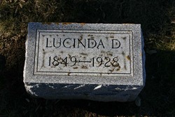
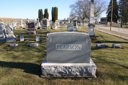
Lucinda D. Davis Pearson
| Birth | : | 11 Feb 1848 Halton Regional Municipality, Ontario, Canada |
| Death | : | 18 Sep 1928 Miles, Jackson County, Iowa, USA |
| Burial | : | All Saints Churchyard, Winterton, North Lincolnshire Unitary Authority, England |
| Coordinate | : | 53.6555710, -0.5968640 |
| Description | : | INFORMATION COURTESY OF LORAINE ERTELT: Lucinda D. Springer Pearson was born in 1848 to Lucinda Springer who passed away shortly after the birth of her daughter, due indirectly to a friend visiting her during a rain storm. When the friend came into the room with a wet umbrella Lucinda caught a cold, pneumonia set in and she passed away. Lucinda Springer died February 13, 1848 so her daughter had to have been born in 1848. Wife of Theodore A. Pearson (1850... Read More |
frequently asked questions (FAQ):
-
Where is Lucinda D. Davis Pearson's memorial?
Lucinda D. Davis Pearson's memorial is located at: All Saints Churchyard, Winterton, North Lincolnshire Unitary Authority, England.
-
When did Lucinda D. Davis Pearson death?
Lucinda D. Davis Pearson death on 18 Sep 1928 in Miles, Jackson County, Iowa, USA
-
Where are the coordinates of the Lucinda D. Davis Pearson's memorial?
Latitude: 53.6555710
Longitude: -0.5968640
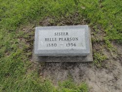
Family Members:
Parent

Spouse

Siblings
Children

Flowers:


Nearby Cemetories:
1. All Saints Churchyard
Winterton, North Lincolnshire Unitary Authority, England
Coordinate: 53.6555710, -0.5968640
2. Winterton Cemetery
Winterton, North Lincolnshire Unitary Authority, England
Coordinate: 53.6548190, -0.5847270
3. All Saints Churchyard
Winteringham, North Lincolnshire Unitary Authority, England
Coordinate: 53.6902800, -0.6010700
4. All Saints Churchyard
Winteringham, North Lincolnshire Unitary Authority, England
Coordinate: 53.6904182, -0.6010190
5. St Bartholomew's Church
Appleby, North Lincolnshire Unitary Authority, England
Coordinate: 53.6234280, -0.5603240
6. Alkborough Cemetery
Alkborough, North Lincolnshire Unitary Authority, England
Coordinate: 53.6816460, -0.6686090
7. St Andrew's Church
Burton upon Stather, North Lincolnshire Unitary Authority, England
Coordinate: 53.6501180, -0.6850550
8. St Maurice Churchyard
Horkstow, North Lincolnshire Unitary Authority, England
Coordinate: 53.6512040, -0.5079660
9. St Nicholas Churchyard
South Ferriby, North Lincolnshire Unitary Authority, England
Coordinate: 53.6746420, -0.5051450
10. St John the Baptist
Whitton, North Lincolnshire Unitary Authority, England
Coordinate: 53.7093390, -0.6342340
11. All Saints' Churchyard
Flixborough, North Lincolnshire Unitary Authority, England
Coordinate: 53.6247100, -0.6819480
12. All Saints' Churchyard
Saxby-All-Saints, North Lincolnshire Unitary Authority, England
Coordinate: 53.6372500, -0.5010260
13. All Saints Churchyard Old
Flixborough, North Lincolnshire Unitary Authority, England
Coordinate: 53.6178950, -0.6754930
14. St Mary the Virgin Church
Fockerby, North Lincolnshire Unitary Authority, England
Coordinate: 53.6613050, -0.7138730
15. Crosby Cemetery
Scunthorpe, North Lincolnshire Unitary Authority, England
Coordinate: 53.5978800, -0.6639600
16. Scunthorpe Cemetery
Scunthorpe, North Lincolnshire Unitary Authority, England
Coordinate: 53.5932400, -0.6512140
17. St Andrew Churchyard
Bonby, North Lincolnshire Unitary Authority, England
Coordinate: 53.6266000, -0.4838000
18. St Marks Church
Amcotts, North Lincolnshire Unitary Authority, England
Coordinate: 53.6166950, -0.7088900
19. St Lawrence Churchyard
Scunthorpe, North Lincolnshire Unitary Authority, England
Coordinate: 53.5864180, -0.6554010
20. All Saints Churchyard
Adlingfleet, East Riding of Yorkshire Unitary Authority, England
Coordinate: 53.6786760, -0.7238110
21. Welton Church Cemetery
Brough, East Riding of Yorkshire Unitary Authority, England
Coordinate: 53.7297800, -0.5514800
22. Brumby Cemetery
Scunthorpe, North Lincolnshire Unitary Authority, England
Coordinate: 53.5799400, -0.6448700
23. St Oswald Church
Luddington, North Lincolnshire Unitary Authority, England
Coordinate: 53.6448740, -0.7387490
24. Broughton Cemetery
Broughton, North Lincolnshire Unitary Authority, England
Coordinate: 53.5732500, -0.5582900