
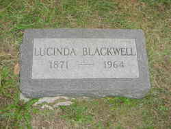
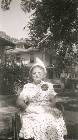
Lucinda “Dollie” Wickam Blackwell
| Birth | : | 31 Aug 1871 Pomona, Franklin County, Kansas, USA |
| Death | : | 18 Mar 1964 Franklin County, Kansas, USA |
| Burial | : | Woodlawn Cemetery, Pomona, Franklin County, USA |
| Coordinate | : | 38.6100006, -95.4681015 |
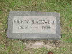
| Description | : | She married 1st Harkey Walter Huskey Aug 20, 1891 in Pomona, Franklin, KS. They moved to LaPorte, TX in 1899 where they both were teachers, Walter as a Principal and Lucinda in the primary grades. They were divorced. She married Dickamond W. 'Dick' Blackwell, who was her 1st cousin, Sept 18, 1909 in Weiser, Washington, ID. Details For Marriage ID#74730 Groom Last Name: BLACKWELL Groom First Name: Dick W. Groom Residence: Bride Last Name: WICKHAM Bride First Name: Lucinda Bride Residence: Place: Weiser Date: 18 Sep 1909 County of Record: Washington State: Idaho Volume: 4 Page: 402 |
frequently asked questions (FAQ):
-
Where is Lucinda “Dollie” Wickam Blackwell's memorial?
Lucinda “Dollie” Wickam Blackwell's memorial is located at: Woodlawn Cemetery, Pomona, Franklin County, USA.
-
When did Lucinda “Dollie” Wickam Blackwell death?
Lucinda “Dollie” Wickam Blackwell death on 18 Mar 1964 in Franklin County, Kansas, USA
-
Where are the coordinates of the Lucinda “Dollie” Wickam Blackwell's memorial?
Latitude: 38.6100006
Longitude: -95.4681015
Family Members:
Parent
Spouse
Siblings


Children
Flowers:


Nearby Cemetories:
1. Woodlawn Cemetery
Pomona, Franklin County, USA
Coordinate: 38.6100006, -95.4681015
2. Nightingale Farm Cemetery
Pomona, Franklin County, USA
Coordinate: 38.5815300, -95.4409300
3. Eastview Cemetery
Quenemo, Osage County, USA
Coordinate: 38.6081009, -95.5235977
4. Greenwood Cemetery
Franklin County, USA
Coordinate: 38.5781700, -95.4145900
5. Oak Hill Cemetery
Quenemo, Osage County, USA
Coordinate: 38.5918999, -95.5333023
6. Pleasant Ridge Cemetery
Osage County, USA
Coordinate: 38.6492004, -95.5271988
7. Central Cemetery
Pomona, Franklin County, USA
Coordinate: 38.5352936, -95.4522629
8. Parkinson Cemetery
Franklin County, USA
Coordinate: 38.6479500, -95.3804800
9. Chippewa Hills Cemetery
Ottawa, Franklin County, USA
Coordinate: 38.5913100, -95.3649200
10. Humphreys Cemetery
Quenemo, Osage County, USA
Coordinate: 38.5398300, -95.5316200
11. Munsee Indian Cemetery
Ottawa, Franklin County, USA
Coordinate: 38.5677986, -95.3688965
12. Salt Creek Cemetery
Osage County, USA
Coordinate: 38.6164100, -95.5875300
13. Dean Cemetery
Pomona, Franklin County, USA
Coordinate: 38.7038994, -95.4781036
14. Mount Pleasant Cemetery
Homewood, Franklin County, USA
Coordinate: 38.5397000, -95.3787700
15. Lamont Hill Cemetery
Vassar, Osage County, USA
Coordinate: 38.6392400, -95.6004600
16. Antioch Cemetery
Homewood, Franklin County, USA
Coordinate: 38.5388985, -95.3593979
17. Evergreen Mound Cemetery
Ottawa, Franklin County, USA
Coordinate: 38.6357994, -95.3225021
18. Foster Cemetery
Ottawa, Franklin County, USA
Coordinate: 38.6651390, -95.3324460
19. Vassar Cemetery
Osage County, USA
Coordinate: 38.6408005, -95.6192017
20. Kaub Cemetery
Centropolis, Franklin County, USA
Coordinate: 38.7172012, -95.3899994
21. Pleasant Hill Cemetery
Centropolis, Franklin County, USA
Coordinate: 38.7243996, -95.4021988
22. Appanoose Cemetery
Globe, Douglas County, USA
Coordinate: 38.7392006, -95.4642029
23. Pleasant View Cemetery
Melvern, Osage County, USA
Coordinate: 38.5064011, -95.5727997
24. Douglas Caldwell Cemetery
Franklin County, USA
Coordinate: 38.4956900, -95.3810400