

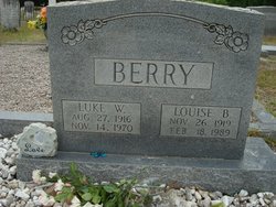
Luke Wallace Berry
| Birth | : | 27 Aug 1916 Branchville, Orangeburg County, South Carolina, USA |
| Death | : | 14 Nov 1970 Branchville, Orangeburg County, South Carolina, USA |
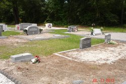
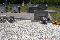
| Burial | : | Taruheru Cemetery, Gisborne, Gisborne District, New Zealand |
| Coordinate | : | -38.6428900, 177.9802300 |
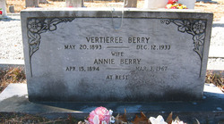
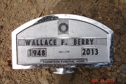
| Description | : | Branchville - Luke W. Berry, 54, a retired employee with the U. S. Plywood Plant of Orangeburg, died Saturday at his home. The funeral will be 3:30 Sunday at the Ott Funeral Home of Branchville. Burial will be in the Sardis Cemetery. Mr. Berry was born in Branchville, the son of the late Vertrie Berry and Mrs. Annie Heaton Berry. Surviving are his widow, Mrs. Louise Berry of Branchville; two sons, Wallace F. Berry of Columbia and Luther D. Berry of Branchville; a daughter, Miss Tammie Lee Berry of Branchville; a brother, Joe Berry of Grove Town, Ga.; two sisters,... Read More |
frequently asked questions (FAQ):
-
Where is Luke Wallace Berry's memorial?
Luke Wallace Berry's memorial is located at: Taruheru Cemetery, Gisborne, Gisborne District, New Zealand.
-
When did Luke Wallace Berry death?
Luke Wallace Berry death on 14 Nov 1970 in Branchville, Orangeburg County, South Carolina, USA
-
Where are the coordinates of the Luke Wallace Berry's memorial?
Latitude: -38.6428900
Longitude: 177.9802300
Family Members:
Parent

Spouse

Siblings

Children
Flowers:


Nearby Cemetories:
1. Taruheru Cemetery
Gisborne, Gisborne District, New Zealand
Coordinate: -38.6428900, 177.9802300
2. Makaraka Cemetery
Gisborne, Gisborne District, New Zealand
Coordinate: -38.6482600, 177.9803200
3. Waerenga a hika Urupā
Gisborne, Gisborne District, New Zealand
Coordinate: -38.5954100, 177.9263500
4. Opou Tuarakena Cemetery
Manutuke, Gisborne District, New Zealand
Coordinate: -38.6744759, 177.9095277
5. Opou Station Cemetery
Manutuke, Gisborne District, New Zealand
Coordinate: -38.6779310, 177.9084450
6. Paramanihi Waihirere Cemetery
Gisborne, Gisborne District, New Zealand
Coordinate: -38.5791250, 177.9488450
7. Manutuke Churchyard Urupā
Manutuke, Gisborne District, New Zealand
Coordinate: -38.6815360, 177.9080180
8. Patutahi Cemetery
Gisborne, Gisborne District, New Zealand
Coordinate: -38.6199300, 177.8955600
9. Manutuke Whakato Urupā
Manutuke, Gisborne District, New Zealand
Coordinate: -38.6843390, 177.9073690
10. Wainui
Gisborne District, New Zealand
Coordinate: -38.6950000, 178.0707400
11. Ormond Cemetery
Ormond, Gisborne District, New Zealand
Coordinate: -38.5526480, 177.9279330
12. Pouawa Urupā
Whangara, Gisborne District, New Zealand
Coordinate: -38.6085500, 178.1825900
13. Whangara Urupā
Whangara, Gisborne District, New Zealand
Coordinate: -38.5716800, 178.2310400
14. Tapuae o te Rangi Urupā
Whatatutu, Gisborne District, New Zealand
Coordinate: -38.3791200, 177.8134180
15. Kohimarama Urupā
Tolaga Bay, Gisborne District, New Zealand
Coordinate: -38.3791770, 178.3007610
16. Nuhaka North Cemetery
Morere, Wairoa District, New Zealand
Coordinate: -38.9797100, 177.7944300
17. Tolaga Bay Cemetery
Tolaga Bay, Gisborne District, New Zealand
Coordinate: -38.3643370, 178.3045240
18. Tolaga Bay Urupā
Tolaga Bay, Gisborne District, New Zealand
Coordinate: -38.3629400, 178.3050080
19. Rakauroa Cemetery
Matawai, Gisborne District, New Zealand
Coordinate: -38.4358900, 177.5711400
20. Okuri Marea Urupa
Tolaga Bay, Gisborne District, New Zealand
Coordinate: -38.3055250, 178.2704340
21. Arataiha Urupā
Nuhaka, Wairoa District, New Zealand
Coordinate: -39.0201020, 177.7361770
22. Opoutama Cemetery
Mahia, Wairoa District, New Zealand
Coordinate: -39.0550780, 177.8405420
23. Manawarakau Urupā
Nuhaka, Wairoa District, New Zealand
Coordinate: -39.0371870, 177.7262650
24. Kaiuku Marae Urupā
Mahia, Wairoa District, New Zealand
Coordinate: -39.0823112, 177.9086516