
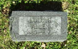
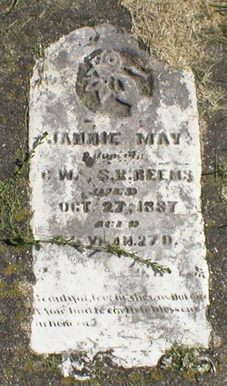
Lulu Gertrude Beems Allen
| Birth | : | 2 Oct 1880 Mason City, Cerro Gordo County, Iowa, USA |
| Death | : | 30 Mar 1972 Garden Valley, El Dorado County, California, USA |
| Burial | : | Onida Cemetery, Onida, Sully County, USA |
| Coordinate | : | 44.7147000, -100.0650000 |
| Plot | : | Section C |
| Description | : | **thanks to Find A Grave contributor, DAST for the following information: this is a cenotaph memorial, she has a stone here in Holton Cemetery between her two husbands, but she is buried in California, that memorial can be seen here OBITUARY Mountain Democrat Placerville, El Dorado Co., CA Publish date: April 6, 1972 Funeral services for Lulu Allen, 91, of Garden Valley, were held Monday, April 3 at Chapel of the Pines. Entombment at Garden Crypts in the Placerville Union cemetery. The Rev. Richard Dewsnap of the Garden Valley Chapel conducted the servies. Mrs. Allen died March 30 in a local convalescent hospital. She... Read More |
frequently asked questions (FAQ):
-
Where is Lulu Gertrude Beems Allen's memorial?
Lulu Gertrude Beems Allen's memorial is located at: Onida Cemetery, Onida, Sully County, USA.
-
When did Lulu Gertrude Beems Allen death?
Lulu Gertrude Beems Allen death on 30 Mar 1972 in Garden Valley, El Dorado County, California, USA
-
Where are the coordinates of the Lulu Gertrude Beems Allen's memorial?
Latitude: 44.7147000
Longitude: -100.0650000
Family Members:
Parent

Spouse
Siblings
Children
Flowers:


Nearby Cemetories:
1. Onida Cemetery
Onida, Sully County, USA
Coordinate: 44.7147000, -100.0650000
2. Holy Rosary Cemetery
Agar, Sully County, USA
Coordinate: 44.8380000, -100.0616000
3. Schreiber Cemetery
Agar, Sully County, USA
Coordinate: 44.8821983, -100.1196976
4. Pleasant Hill Cemetery
Blunt, Hughes County, USA
Coordinate: 44.5135994, -100.0156021
5. Pleasant Cemetery
Sully County, USA
Coordinate: 44.6927986, -99.7568970
6. Okobojo Cemetery
Sully County, USA
Coordinate: 44.6568985, -100.3647003
7. Byron Township Cemetery
Blunt, Hughes County, USA
Coordinate: 44.4979200, -100.1904700
8. Blair Cemetery
Sully County, USA
Coordinate: 44.8027992, -100.4199982
9. Petro Family Cemetery
Gettysburg, Potter County, USA
Coordinate: 44.9706825, -100.2259903
10. Sacred Heart Cemetery
Gettysburg, Potter County, USA
Coordinate: 44.9982986, -99.9377975
11. Medicine Hill Cemetery
Harrold, Hughes County, USA
Coordinate: 44.5116997, -99.7453003
12. Copp Cemetery
Potter County, USA
Coordinate: 44.9118935, -99.7358236
13. Saint John Catholic Cemetery
Harrold, Hughes County, USA
Coordinate: 44.5127983, -99.7335968
14. Gettysburg Memorial Cemetery
Gettysburg Township, Potter County, USA
Coordinate: 45.0208146, -99.9898400
15. Canning Cemetery
Hughes County, USA
Coordinate: 44.3986890, -100.0278460
16. Gettysburg Cemetery
Gettysburg, Potter County, USA
Coordinate: 45.0149994, -99.9199982
17. Forest City Cemetery (Defunct)
Forest City, Potter County, USA
Coordinate: 45.0239900, -100.2667000
18. Mount Calvary Cemetery
Pierre, Hughes County, USA
Coordinate: 44.4197006, -100.3557968
19. Spring Lake Cemetery
Hyde County, USA
Coordinate: 44.7942009, -99.5610962
20. Riverside Cemetery
Pierre, Hughes County, USA
Coordinate: 44.3608017, -100.3071976
21. Scotty Philip Cemetery
Fort Pierre, Stanley County, USA
Coordinate: 44.4019012, -100.4036026
22. Fort Pierre Chouteau Cemetery
Fort Pierre, Stanley County, USA
Coordinate: 44.3908700, -100.3878300
23. South Dakota State Capitol Grounds
Pierre, Hughes County, USA
Coordinate: 44.3660100, -100.3448000
24. Lebanon Cemetery
Lebanon, Potter County, USA
Coordinate: 45.0635500, -99.7768400