
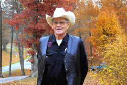
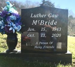
Luther Gaw McBride
| Birth | : | 15 Jan 1943 Clay County, Tennessee, USA |
| Death | : | 13 Oct 2020 Cookeville, Putnam County, Tennessee, USA |
| Burial | : | Doc Hall Cemetery, Clay County, USA |
| Coordinate | : | 36.4995390, -85.5369270 |
| Description | : | Luther Gaw McBride January 15, 1943 ~ October 13, 2020 (age 77) Mr. Luther Gaw McBride, age 77, of Hilham, TN, passed away on Tuesday, October 13, 2020, at Cookeville Regional Medical Center in Cookeville, TN. He is survived by 1 sister in law Cathy McBride; 5 nephews Joe Spivey and wife Neil, Champ McClain and wife Debbie, Randall McClain and wife Nancy, Dennis McClain and wife Antia, Chad McBride, and wife Tammy; 9 nieces Joyce Strong and husband Steven, Jean Allen and husband Johnny, Gail Long and husband Ronnie, Gin Scantland and husband Dale, Betty Plumlee and... Read More |
frequently asked questions (FAQ):
-
Where is Luther Gaw McBride's memorial?
Luther Gaw McBride's memorial is located at: Doc Hall Cemetery, Clay County, USA.
-
When did Luther Gaw McBride death?
Luther Gaw McBride death on 13 Oct 2020 in Cookeville, Putnam County, Tennessee, USA
-
Where are the coordinates of the Luther Gaw McBride's memorial?
Latitude: 36.4995390
Longitude: -85.5369270
Family Members:
Parent

Spouse
Siblings
Flowers:


Nearby Cemetories:
1. Doc Hall Cemetery
Clay County, USA
Coordinate: 36.4995390, -85.5369270
2. Hall Cemetery
Clay County, USA
Coordinate: 36.4994011, -85.5366974
3. John Hamilton Cemetery
Butlers Landing, Clay County, USA
Coordinate: 36.4916010, -85.5489080
4. Mabry Cemetery
Clay County, USA
Coordinate: 36.5139008, -85.5464020
5. Emberton Cemetery
Celina, Clay County, USA
Coordinate: 36.4862150, -85.5237040
6. Hamilton Cemetery
Clay County, USA
Coordinate: 36.5181007, -85.5338974
7. Butlers Landing Cemetery
Celina, Clay County, USA
Coordinate: 36.4941300, -85.5600410
8. McColgan Cemetery
Clay County, USA
Coordinate: 36.5163994, -85.5560989
9. Kirk Cemetery
Clay County, USA
Coordinate: 36.4960670, -85.5661650
10. McDonald Cemetery
Baptist Ridge, Clay County, USA
Coordinate: 36.4855995, -85.5119019
11. Lester Brown Family Cemetery
Arcott, Clay County, USA
Coordinate: 36.5205700, -85.5547530
12. M R Cemetery
Baptist Ridge, Clay County, USA
Coordinate: 36.4769100, -85.5196770
13. Roberts Cemetery
Celina, Clay County, USA
Coordinate: 36.5066986, -85.5727997
14. Archibald Plumlee Cemetery
Pine Hill, Clay County, USA
Coordinate: 36.5203018, -85.5682983
15. Rich Cemetery
Baptist Ridge, Clay County, USA
Coordinate: 36.4757080, -85.4991700
16. Goolsby Cemetery
Clay County, USA
Coordinate: 36.4603640, -85.5368040
17. Turkeytown Cemetery
Clay County, USA
Coordinate: 36.4569016, -85.5177994
18. Dalton Cemetery
Arcott, Clay County, USA
Coordinate: 36.5429540, -85.5546170
19. Amos Kirkpatrick-Tinsley Cemetery
Jackson County, USA
Coordinate: 36.4715080, -85.5867230
20. John Fowler Cemetery
Butlers Landing, Clay County, USA
Coordinate: 36.4910900, -85.5972590
21. High Cedar Cemetery
Clay County, USA
Coordinate: 36.4827710, -85.5974970
22. Rich-Lynn Family Cemetery
Butlers Landing, Clay County, USA
Coordinate: 36.4794140, -85.5987380
23. Hix Cemetery
Jackson County, USA
Coordinate: 36.4580810, -85.5815000
24. Peterman Bend Cemetery
Celina, Clay County, USA
Coordinate: 36.5370750, -85.4846300