
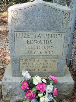

Luzetta A. Perrel Edwards
| Birth | : | 10 Feb 1850 Forsyth County, North Carolina, USA |
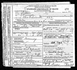
| Death | : | 5 Jul 1940 Bethania, Forsyth County, North Carolina, USA |
| Burial | : | Edwards Cemetery, Stokes County, USA |
| Coordinate | : | 36.3196983, -80.4156036 |
| Inscription | : | "SHE WAS A KIND AND AFFECTIONATE WIFE, A FOND MOTHER AND A FRIEND TO ALL" |
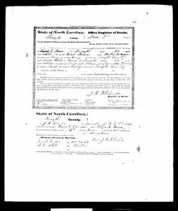
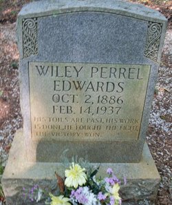
| Description | : | Daughter of Emanuel Perrel & Lucinda Westmoreland One of seven children; 4 sisters & 2 brothers ************************************ 1847 Rebecca (Pulliam)***see below 1848 Eliza Adeline (Moser)***see below 1853 Sarah Holloway (Flynt)***see below 1854 John Henry***see below 1858 Alexander Lippo***see below 1863 Mary Ellen (Westmoreland)***see below Married Abel S. Edwards 12 Jan 1884 Stokes Co, NC Mother of three children; 1 daughter & 2 sons ************************************ 188? Lucinda 1886 Wiley Perrel 1889 Edward Emanuel "Ned" |
frequently asked questions (FAQ):
-
Where is Luzetta A. Perrel Edwards's memorial?
Luzetta A. Perrel Edwards's memorial is located at: Edwards Cemetery, Stokes County, USA.
-
When did Luzetta A. Perrel Edwards death?
Luzetta A. Perrel Edwards death on 5 Jul 1940 in Bethania, Forsyth County, North Carolina, USA
-
Where are the coordinates of the Luzetta A. Perrel Edwards's memorial?
Latitude: 36.3196983
Longitude: -80.4156036
Family Members:
Parent
Spouse
Siblings
Children
Flowers:


Nearby Cemetories:
1. Edwards Cemetery
Stokes County, USA
Coordinate: 36.3196983, -80.4156036
2. David Nicholas Dalton Family Cemetery
Dalton, Stokes County, USA
Coordinate: 36.3044930, -80.3955430
3. Chestnut Grove United Methodist Church Cemetery
Chestnut Grove, Stokes County, USA
Coordinate: 36.3229670, -80.3847640
4. Dalton Chapel Cemetery
Dalton, Stokes County, USA
Coordinate: 36.2975780, -80.3900820
5. King Family Cemetery
Pilot Mountain, Surry County, USA
Coordinate: 36.3307780, -80.4532780
6. Badgett Family Cemetery
Chestnut Grove, Stokes County, USA
Coordinate: 36.3416000, -80.3717180
7. Gods Community Cemetery
Shoals, Surry County, USA
Coordinate: 36.2970047, -80.4650726
8. Wolff Family Cemetery
Siloam, Surry County, USA
Coordinate: 36.3008300, -80.4747400
9. Allen Cemetery
Shoals, Surry County, USA
Coordinate: 36.3058319, -80.4827805
10. Bennett Cemetery
Stokes County, USA
Coordinate: 36.3483009, -80.3518982
11. Old Friends Union Cemetery
Surry County, USA
Coordinate: 36.2679550, -80.4534680
12. Lawrence Cemetery
Pilot Mountain, Surry County, USA
Coordinate: 36.3716080, -80.4537230
13. Mount Pleasant United Methodist Church Cemetery
Tobaccoville, Forsyth County, USA
Coordinate: 36.2549248, -80.4184113
14. Stone Family Cemetery
Pilot Mountain, Surry County, USA
Coordinate: 36.3695070, -80.4689960
15. Newsum Cemetery
Tobaccoville, Forsyth County, USA
Coordinate: 36.2537900, -80.3931800
16. Gilliam Cemetery
Shoals, Surry County, USA
Coordinate: 36.3088989, -80.4993973
17. Friendly Chapel Church Cemetery
Pilot Mountain, Surry County, USA
Coordinate: 36.3635292, -80.4816132
18. Nat'l A Boyden Cemetery
Shoals, Surry County, USA
Coordinate: 36.2632380, -80.4697250
19. First Baptist of Saura Valley Church Cemetery
Boyles Chapel, Stokes County, USA
Coordinate: 36.3659150, -80.3471800
20. Fairview United Methodist Church Cemetery
Shoals, Surry County, USA
Coordinate: 36.3126945, -80.5045853
21. Boyles Chapel Primitive Baptist Church Cemetery
Boyles Chapel, Stokes County, USA
Coordinate: 36.3493048, -80.3306086
22. Newsome Family Cemetery
Tobaccoville, Forsyth County, USA
Coordinate: 36.2437710, -80.3925400
23. Stoney Ridge AME Zion Church Cemetery
Shoals, Surry County, USA
Coordinate: 36.2914480, -80.5068080
24. Lovells Chapel Church Cemetery
Pilot Mountain, Surry County, USA
Coordinate: 36.3879160, -80.4652290