Lydia H. Tomlin Bedigrew
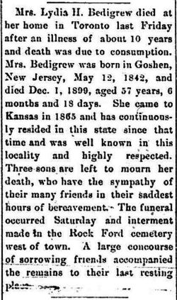
| Birth | : | 12 May 1842 Goshen, Cape May County, New Jersey, USA |
| Death | : | 1 Dec 1899 Toronto, Woodson County, Kansas, USA |
| Burial | : | Means Cemetery, Neal, Greenwood County, USA |
| Coordinate | : | 37.8088989, -96.0516968 |
| Description | : | Daughter of Hathorn Tomlin (1796-1864) and Mary Hand (1797-1854). Husband/1 Dr. John S. Masterson (1835-1/25/1879, Toronto). Children: Korah Ivanhoe Masterson (1866-1951), Julia M. (1868-?), and Mahlon Walter Masterson (1876-1945). Husband/2 James Franklin Bedigrew. James and Lydia Tomlin Masterson married May 11, 1879, at Pleasant Grove, Greenwood County, KS by John R. Rowe, Baptist Minister. James age 18 and Lydia listed as age 28 (actual age 37). Greenwood County Marriage Records,1872-1882, v.B, page 239 James and Lydia's children: Anna L. (b. Apr. 1880 d. July 29, 1884), and Franklin Harvey Bedigrew... Read More |
frequently asked questions (FAQ):
-
Where is Lydia H. Tomlin Bedigrew's memorial?
Lydia H. Tomlin Bedigrew's memorial is located at: Means Cemetery, Neal, Greenwood County, USA.
-
When did Lydia H. Tomlin Bedigrew death?
Lydia H. Tomlin Bedigrew death on 1 Dec 1899 in Toronto, Woodson County, Kansas, USA
-
Where are the coordinates of the Lydia H. Tomlin Bedigrew's memorial?
Latitude: 37.8088989
Longitude: -96.0516968
Family Members:
Parent
Spouse
Children
Flowers:
Nearby Cemetories:
1. Means Cemetery
Neal, Greenwood County, USA
Coordinate: 37.8088989, -96.0516968
2. Neal Cemetery
Neal, Greenwood County, USA
Coordinate: 37.8224983, -96.0631027
3. Bedigrew Family Cemetery
Neal, Greenwood County, USA
Coordinate: 37.8197300, -95.9740300
4. End of the Trail Cemetery
Eureka, Greenwood County, USA
Coordinate: 37.7802410, -96.1484626
5. Quincy Cemetery
Quincy, Greenwood County, USA
Coordinate: 37.8833008, -95.9777985
6. Pleasant Valley Cemetery
Greenwood County, USA
Coordinate: 37.9028015, -96.0207977
7. Watts Haven Cemetery
Quincy, Greenwood County, USA
Coordinate: 37.9077200, -95.9823100
8. Wickersham Cemetery
Fall River, Greenwood County, USA
Coordinate: 37.6935000, -96.0756000
9. Whitehall Cemetery
Fall River, Greenwood County, USA
Coordinate: 37.6775700, -96.0711800
10. Emma's Hill Cemetery
Fall River, Greenwood County, USA
Coordinate: 37.6766400, -96.0790900
11. Worford Cemetery
Hamilton, Greenwood County, USA
Coordinate: 37.9414700, -96.0900400
12. Pike Cemetery (Defunct)
Fall River, Greenwood County, USA
Coordinate: 37.6650009, -96.0681000
13. Stewart Cemetery
Greenwood County, USA
Coordinate: 37.7885100, -96.2347700
14. Virgil Cemetery
Virgil, Greenwood County, USA
Coordinate: 37.9592018, -96.0033035
15. Browns Chapel Cemetery
Fall River, Greenwood County, USA
Coordinate: 37.6498300, -96.0927100
16. Homer Creek Cemetery
Greenwood County, USA
Coordinate: 37.9261017, -96.2097015
17. Charleston Cemetery
Fall River, Greenwood County, USA
Coordinate: 37.6371994, -96.0338974
18. Greenwood Cemetery
Eureka, Greenwood County, USA
Coordinate: 37.8231010, -96.2724991
19. Ott Cemetery
Hamilton, Greenwood County, USA
Coordinate: 37.9686012, -96.1502991
20. Belle Grove Cemetery
Fall River Township, Greenwood County, USA
Coordinate: 37.7133900, -96.2532200
21. Janesville Cemetery
Hamilton, Greenwood County, USA
Coordinate: 37.9853000, -96.1767000
22. Gage Cemetery
Fall River, Greenwood County, USA
Coordinate: 37.6208400, -96.1466100
23. Old Tailor Cemetery
Elk County, USA
Coordinate: 37.5885700, -95.9988700
24. Pleasant View Cemetery
Otter Creek, Greenwood County, USA
Coordinate: 37.6941986, -96.2977982


