
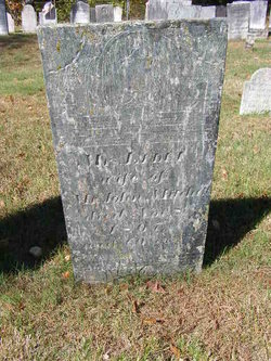
Lydia Johnson Mitchell
| Birth | : | 24 Mar 1744 USA |
| Death | : | 8 Nov 1807 New Hampshire, USA |
| Burial | : | Union Cemetery, Bridgewater, Grafton County, USA |
| Coordinate | : | 43.7093500, -71.6763500 |
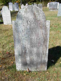
| Inscription | : | Mrs. Lydia | wife of | John Mitchell | died Nov. 8, | 1807, | aged 60 yrs. |
| Description | : | Lydia is the daughter of Michael and Mary (Hancock)Johns(t)on. Michael was born in Ireland before 1728 and died circa May 1762 in Olcotts Falls which is just below Hanover. Lydia was Christened March 25, 1743/44 in Haverhill, Essex County, Massachusetts. She and John were married in Hampstead, Rockingham County, New Hampshire, on October 10, 1767. |
frequently asked questions (FAQ):
-
Where is Lydia Johnson Mitchell's memorial?
Lydia Johnson Mitchell's memorial is located at: Union Cemetery, Bridgewater, Grafton County, USA.
-
When did Lydia Johnson Mitchell death?
Lydia Johnson Mitchell death on 8 Nov 1807 in New Hampshire, USA
-
Where are the coordinates of the Lydia Johnson Mitchell's memorial?
Latitude: 43.7093500
Longitude: -71.6763500
Family Members:
Parent
Spouse
Siblings
Children

Flowers:


Nearby Cemetories:
1. Union Cemetery
Bridgewater, Grafton County, USA
Coordinate: 43.7093500, -71.6763500
2. Mitchell Family Cemetery
Bridgewater, Grafton County, USA
Coordinate: 43.7052780, -71.6838890
3. Lower Intervale Cemetery
Plymouth, Grafton County, USA
Coordinate: 43.7316100, -71.6733800
4. Green Grove Cemetery
Ashland, Grafton County, USA
Coordinate: 43.6975400, -71.6401500
5. Kenfield Cemetery
Bridgewater, Grafton County, USA
Coordinate: 43.6837070, -71.6503550
6. Old Home Cemetery
Bridgewater, Grafton County, USA
Coordinate: 43.6769440, -71.6933330
7. Ashland Episcopal Church Cemetery
Ashland, Grafton County, USA
Coordinate: 43.6963650, -71.6315670
8. Thompson Street Cemetery
Ashland, Grafton County, USA
Coordinate: 43.6975100, -71.6294000
9. Mooney Cemetery
Ashland, Grafton County, USA
Coordinate: 43.7019440, -71.6269440
10. Hicks Hill Cemetery
Ashland, Grafton County, USA
Coordinate: 43.7277780, -71.6313890
11. Baker Cemetery
Ashland, Grafton County, USA
Coordinate: 43.6941990, -71.6254580
12. Church Hill Cemetery
Ashland, Grafton County, USA
Coordinate: 43.7455560, -71.6522220
13. Owl Brook Cemetery
Ashland, Grafton County, USA
Coordinate: 43.7333200, -71.6300100
14. Webster-Cross Cemetery
Bridgewater, Grafton County, USA
Coordinate: 43.6715300, -71.6531200
15. Emerson Cemetery
Bridgewater, Grafton County, USA
Coordinate: 43.6780800, -71.7220300
16. McCutcheon Cemetery
Bridgewater, Grafton County, USA
Coordinate: 43.6636110, -71.6702780
17. Clark Cemetery
Ashland, Grafton County, USA
Coordinate: 43.7133330, -71.6113890
18. Howe-Clark Cemetery
Grafton County, USA
Coordinate: 43.7133330, -71.6113890
19. Trinity Churchyard Cemetery
Holderness, Grafton County, USA
Coordinate: 43.7566000, -71.6696700
20. Nathaniel Robinson Cemetery
New Hampton, Belknap County, USA
Coordinate: 43.6658734, -71.6438178
21. Shaw Cemetery
Holderness, Grafton County, USA
Coordinate: 43.7436110, -71.6225000
22. Wade Hill Cemetery
Hebron, Grafton County, USA
Coordinate: 43.6969300, -71.7469500
23. Ephraim Smith Cemetery
New Hampton, Belknap County, USA
Coordinate: 43.6708670, -71.6242670
24. Chandler Cemetery
New Hampton, Belknap County, USA
Coordinate: 43.6761110, -71.6147220