
| Birth | : | 1696 |
| Death | : | 15 Aug 1745 Plympton, Plymouth County, Massachusetts, USA |
| Burial | : | West Zion Cemetery, Palestine, Darke County, USA |
| Coordinate | : | 40.0411590, -84.7063460 |
| Plot | : | R3-P9-S12 |
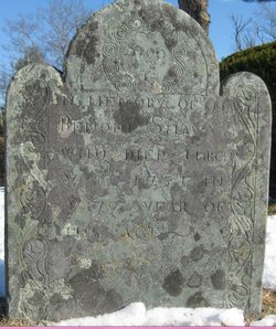
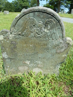
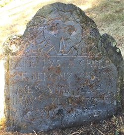
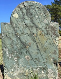
| Description | : | Aged 48 years, 8 months, 25 days Wife of Ebenezer Lobdell Vital Records of Plympton, Massachusetts to the year 1850, Marriages, p. 341 Lobden, Ebenezer [dup. Lobdell] and Lidia [dup. Lydia] Shaw, July 12, 1716. Vital Records of Plympton, Massachusetts to the year 1850, Deaths, p. 489 Lobdell, Lydia Shaw w. Ebenezer, Aug. 15, 1745, a. 48y 8m 25d. |
frequently asked questions (FAQ):
-
Where is Lydia Shaw Lobdell's memorial?
Lydia Shaw Lobdell's memorial is located at: West Zion Cemetery, Palestine, Darke County, USA.
-
When did Lydia Shaw Lobdell death?
Lydia Shaw Lobdell death on 15 Aug 1745 in Plympton, Plymouth County, Massachusetts, USA
-
Where are the coordinates of the Lydia Shaw Lobdell's memorial?
Latitude: 40.0411590
Longitude: -84.7063460
Family Members:
Parent
Spouse

Siblings
Children
Flowers:


Nearby Cemetories:
1. West Zion Cemetery
Palestine, Darke County, USA
Coordinate: 40.0411590, -84.7063460
2. West Branch Cemetery
New Madison, Darke County, USA
Coordinate: 40.0503006, -84.7039032
3. Mount Zion Cemetery
Darke County, USA
Coordinate: 40.0417000, -84.6839000
4. Miller Grove German Baptist Church Cemetery
Palestine, Darke County, USA
Coordinate: 40.0554700, -84.7269280
5. Clark Station Cemetery
Clark, Darke County, USA
Coordinate: 40.0147250, -84.7209360
6. Saint John's Cemetery
Palestine, Darke County, USA
Coordinate: 40.0350000, -84.7447000
7. Palestine Cemetery
Palestine, Darke County, USA
Coordinate: 40.0539690, -84.7424930
8. Pioneer Cemetery
Fort Jefferson, Darke County, USA
Coordinate: 40.0272700, -84.6569000
9. Oak Grove Cemetery
Fort Jefferson, Darke County, USA
Coordinate: 40.0233002, -84.6528015
10. Wayne Lakes Cemetery
Fort Jefferson, Darke County, USA
Coordinate: 40.0156040, -84.6580110
11. Beech Grove Cemetery
Hollansburg, Darke County, USA
Coordinate: 40.0157000, -84.7570700
12. Mills Cemetery
New Madison, Darke County, USA
Coordinate: 39.9947014, -84.6797028
13. Dininger Cemetery
Coletown, Darke County, USA
Coordinate: 40.0918999, -84.7069016
14. Hiller Cemetery
Washington Township, Darke County, USA
Coordinate: 40.0995310, -84.7077570
15. Nashville Cemetery
Nashville, Darke County, USA
Coordinate: 40.0924630, -84.7429060
16. Spencer Cemetery
New Madison, Darke County, USA
Coordinate: 39.9939600, -84.7616140
17. Downing Cemetery
New Madison, Darke County, USA
Coordinate: 39.9915330, -84.7639610
18. Harter Cemetery
New Madison, Darke County, USA
Coordinate: 39.9747009, -84.6949997
19. Horn Cemetery
Hollansburg, Darke County, USA
Coordinate: 40.0322970, -84.7984670
20. Sharpeye Cemetery
Washington Township, Darke County, USA
Coordinate: 40.1064360, -84.7441260
21. Darke County Home Cemetery
Greenville Township, Darke County, USA
Coordinate: 40.0663986, -84.6185989
22. First Universalist Church Cemetery
New Madison, Darke County, USA
Coordinate: 39.9667280, -84.7058340
23. Church of God Cemetery
Greenville, Darke County, USA
Coordinate: 40.0677290, -84.6154430
24. Bass Cemetery
Long, Darke County, USA
Coordinate: 40.0638510, -84.7990330