
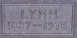
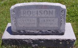
Lynn “Lynn” Robertson
| Birth | : | 19 Jun 1887 Atchison, Atchison County, Kansas, USA |
| Death | : | 7 Oct 1976 Yates Center, Woodson County, Kansas, USA |
| Burial | : | Lovell Lake Cemetery, Sanbornville, Carroll County, USA |
| Coordinate | : | 43.5506000, -71.0244000 |
| Description | : | Father of Lawrence Robison. Campbell Funeral Home in charge of arrangements. Lynn Robison, 89, a retired farmer from Neosho Falls, died Thursday evening at the Hill Crest Nursing Home in Yates Center. He was a brother of Miss Gladys Robison and Mrs. M. W. Wilson, 409 Constitution St. Graveside services will be held Saturday at 2 p.m. in the Burlingame Cemetery. The Campbell Funeral Home in Yates Center is in charge of arrangements. Mr. Robison is also survived by two sons, Lawrence and James Robison, Nesoho Falls. Emporia, KS Gazette-October 8, 1977 Contributed by Thomas Hotchkiss |
frequently asked questions (FAQ):
-
Where is Lynn “Lynn” Robertson's memorial?
Lynn “Lynn” Robertson's memorial is located at: Lovell Lake Cemetery, Sanbornville, Carroll County, USA.
-
When did Lynn “Lynn” Robertson death?
Lynn “Lynn” Robertson death on 7 Oct 1976 in Yates Center, Woodson County, Kansas, USA
-
Where are the coordinates of the Lynn “Lynn” Robertson's memorial?
Latitude: 43.5506000
Longitude: -71.0244000
Family Members:
Parent
Spouse
Children
Flowers:


Nearby Cemetories:
1. Hutchins Cemetery
Wakefield, Carroll County, USA
Coordinate: 43.5481000, -71.0330000
2. Saint Anthonys Cemetery
Sanbornville, Carroll County, USA
Coordinate: 43.5494500, -71.0386710
3. Hutchins Brackett Farm Cemetery
Sanbornville, Carroll County, USA
Coordinate: 43.5573807, -71.0097885
4. Sanborn Cemetery 35
Wakefield, Carroll County, USA
Coordinate: 43.5656189, -71.0039812
5. Historic Wakefield Corner Burial Ground
Wakefield, Carroll County, USA
Coordinate: 43.5719719, -71.0258713
6. Gilman Cemetery
Wakefield, Carroll County, USA
Coordinate: 43.5316670, -71.0383330
7. Ferguson-Chamberlain Cemetery
Brookfield, Carroll County, USA
Coordinate: 43.5327000, -71.0408000
8. Dealand Cemetery
Brookfield, Carroll County, USA
Coordinate: 43.5452510, -71.0532190
9. Clark Cemetery
Brookfield, Carroll County, USA
Coordinate: 43.5274710, -71.0299160
10. Belknap Cemetery
Brookfield, Carroll County, USA
Coordinate: 43.5361050, -71.0515020
11. Cate Cemetery
Brookfield, Carroll County, USA
Coordinate: 43.5382200, -71.0545920
12. Wentworth-Garvin Cemetery
Wakefield, Carroll County, USA
Coordinate: 43.5680560, -70.9983330
13. Buzzell Cemetery
Brookfield, Carroll County, USA
Coordinate: 43.5395890, -71.0571670
14. Gage Hill Cemetery
Wakefield, Carroll County, USA
Coordinate: 43.5743900, -71.0408300
15. Churchill Family Cemetery
Brookfield, Carroll County, USA
Coordinate: 43.5494000, -71.0625000
16. Churchill Cemetery
Brookfield, Carroll County, USA
Coordinate: 43.5476000, -71.0650000
17. Pike Cemetery
Brookfield, Carroll County, USA
Coordinate: 43.5735220, -71.0515990
18. Hutchins Family Cemetery
Sanbornville, Carroll County, USA
Coordinate: 43.5319366, -70.9909897
19. Pike Cemetery
Brookfield, Carroll County, USA
Coordinate: 43.5318500, -70.9910667
20. Garland Family Cemetery
Wakefield, Carroll County, USA
Coordinate: 43.5313000, -70.9902000
21. Dodavah Copp Burial Site
Wakefield, Carroll County, USA
Coordinate: 43.5767308, -70.9995894
22. Allen Cemetery
Wakefield, Carroll County, USA
Coordinate: 43.5185300, -71.0269400
23. Dow Cemetery
Wakefield, Carroll County, USA
Coordinate: 43.5825000, -71.0150000
24. Robinson Cemetery
Brookfield, Carroll County, USA
Coordinate: 43.5694000, -71.0645000