
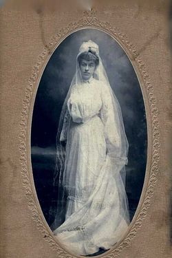
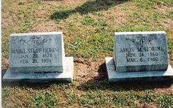
Mabel Estelle Stupp Horine
| Birth | : | 23 Jan 1878 Martinsburg, Berkeley County, West Virginia, USA |
| Death | : | 21 Feb 1953 Westminster, Carroll County, Maryland, USA |
| Burial | : | Walpole St Andrew, Walpole, Kings Lynn and West Norfolk Borough, England |
| Coordinate | : | 52.7349520, 0.2227630 |
| Plot | : | Section 3, Row 7, Grouping 13 |
frequently asked questions (FAQ):
-
Where is Mabel Estelle Stupp Horine's memorial?
Mabel Estelle Stupp Horine's memorial is located at: Walpole St Andrew, Walpole, Kings Lynn and West Norfolk Borough, England.
-
When did Mabel Estelle Stupp Horine death?
Mabel Estelle Stupp Horine death on 21 Feb 1953 in Westminster, Carroll County, Maryland, USA
-
Where are the coordinates of the Mabel Estelle Stupp Horine's memorial?
Latitude: 52.7349520
Longitude: 0.2227630
Family Members:
Parent

Spouse
Siblings
Children
Flowers:

Left by Anonymous on 25 Mar 2009

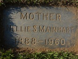
Surviving are two children Randolph A. Horine and Mrs. Andrew Kuhber, Westminster; four grandchildren; a brother and three sisters, Leroy B Stupp, Mrs. Al George, Mrs. Nellie Mainhart, and Mrs. Merrill Stevens.- Carroll County Times 26 Feb 1953
Left by Anonymous on 28 Jan 2016

Left by Anonymous on 01 Jan 2020


Nearby Cemetories:
1. Walpole St Andrew
Walpole, Kings Lynn and West Norfolk Borough, England
Coordinate: 52.7349520, 0.2227630
2. Walpole St Andrew - Extension
Walpole, Kings Lynn and West Norfolk Borough, England
Coordinate: 52.7314600, 0.2162800
3. St. Peter's Churchyard
Walpole, Kings Lynn and West Norfolk Borough, England
Coordinate: 52.7284200, 0.2219100
4. St. John's Churchyard
Terrington St John, Kings Lynn and West Norfolk Borough, England
Coordinate: 52.7183750, 0.2778270
5. St. Matthew's Churchyard
Sutton Bridge, South Holland District, England
Coordinate: 52.7682100, 0.1903100
6. Terrington Saint Clement Methodist Cemetery
Terrington St Clement, Kings Lynn and West Norfolk Borough, England
Coordinate: 52.7589440, 0.2899360
7. Tilney St. Lawrence Churchyard
Tilney St Lawrence, Kings Lynn and West Norfolk Borough, England
Coordinate: 52.7089510, 0.2923460
8. St. Mary Churchyard
Tydd St Mary, South Holland District, England
Coordinate: 52.7456600, 0.1404600
9. St Clement Churchyard
Terrington St Clement, Kings Lynn and West Norfolk Borough, England
Coordinate: 52.7593100, 0.2975600
10. Tilney All Saints Churchyard
Tilney All Saints, Kings Lynn and West Norfolk Borough, England
Coordinate: 52.7366790, 0.3214680
11. St Mary's Church Islington
Tilney All Saints, Kings Lynn and West Norfolk Borough, England
Coordinate: 52.7268530, 0.3246890
12. All Saints Churchyard
Walsoken, Kings Lynn and West Norfolk Borough, England
Coordinate: 52.6721700, 0.1816130
13. St. Giles' Churchyard
Tydd St Giles, Fenland District, England
Coordinate: 52.7269470, 0.1118120
14. Mount Pleasant Cemetery
Wisbech, Fenland District, England
Coordinate: 52.6719840, 0.1644770
15. Marshland St. James Cemetery
Marshland St James, Kings Lynn and West Norfolk Borough, England
Coordinate: 52.6604540, 0.2465520
16. St Augustine Churchyard
Wisbech, Fenland District, England
Coordinate: 52.6679000, 0.1633300
17. Long Sutton Cemetery
Long Sutton, South Holland District, England
Coordinate: 52.7848300, 0.1272300
18. St. Mary's Churchyard
Long Sutton, South Holland District, England
Coordinate: 52.7844700, 0.1221800
19. Long Sutton Baptist Churchyard
Long Sutton, South Holland District, England
Coordinate: 52.7837460, 0.1204960
20. St Peter & St Paul Churchyard
Wisbech, Fenland District, England
Coordinate: 52.6639880, 0.1626020
21. St Margaret's Churchyard
Clenchwarton, Kings Lynn and West Norfolk Borough, England
Coordinate: 52.7569690, 0.3548660
22. Gorefield Congregational Churchyard
Gorefield, Fenland District, England
Coordinate: 52.6865500, 0.0968700
23. St Paul Churchyard
Gorefield, Fenland District, England
Coordinate: 52.6873400, 0.0944700
24. St. Edmund Churchyard
Emneth, Kings Lynn and West Norfolk Borough, England
Coordinate: 52.6438200, 0.1989100