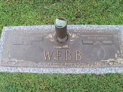
| Birth | : | 26 Aug 1918 Benton County, Tennessee, USA |
| Death | : | 13 Apr 2002 Camden, Benton County, Tennessee, USA |
| Burial | : | Rosemont Cemetery (Defunct), Garfield Heights, District of Columbia, USA |
| Coordinate | : | 38.8527985, -76.9788971 |
| Description | : | Married 1933 Mable Brown (29510456) Obituary: Services for Mrs. Mable Marie Brown, 83, were held 11:00 A.M. Monday, April 15, 2002 at Stockdale-Malin Chapel in Camden with Bro. Leonard Greer officiating. Pallbearers were Joe Brown, Michael Virginiak, Johnny Greer, Edwin Greer, and Dwayne Webb. Burial followed in Shiloh Methodist Church Cemetery. Mrs. Brown was born Aug. 26, 1918 in Benton County to the late Guy Cole and Beatrice Trout Cole, and was retired from Henry I. Seigel (Inspector). Mrs. Brown died Saturday, April 13, 2002 at Camden General Hospital in Camden, TN. |
frequently asked questions (FAQ):
-
Where is Mable Marie Cole Brown's memorial?
Mable Marie Cole Brown's memorial is located at: Rosemont Cemetery (Defunct), Garfield Heights, District of Columbia, USA.
-
When did Mable Marie Cole Brown death?
Mable Marie Cole Brown death on 13 Apr 2002 in Camden, Benton County, Tennessee, USA
-
Where are the coordinates of the Mable Marie Cole Brown's memorial?
Latitude: 38.8527985
Longitude: -76.9788971
Family Members:
Spouse
Children
Flowers:
Nearby Cemetories:
1. Rosemont Cemetery (Defunct)
Garfield Heights, District of Columbia, USA
Coordinate: 38.8527985, -76.9788971
2. Rosewood Cemetery (Defunct)
Anacostia, District of Columbia, USA
Coordinate: 38.8525009, -76.9783020
3. Hillsdale Cemetery (Defunct)
Douglass, District of Columbia, USA
Coordinate: 38.8520654, -76.9825828
4. Elesavetgrad Cemetery
Anacostia, District of Columbia, USA
Coordinate: 38.8483500, -76.9828200
5. Saint Elizabeths Hospital East Cemetery
Anacostia, District of Columbia, USA
Coordinate: 38.8493996, -76.9869003
6. Adas Israel Cemetery
Washington, District of Columbia, USA
Coordinate: 38.8457990, -76.9844730
7. Washington Hebrew Congregation Cemetery
Washington, District of Columbia, USA
Coordinate: 38.8454480, -76.9858040
8. Ohev Sholom Congregation Cemetery
Congress Heights, District of Columbia, USA
Coordinate: 38.8453640, -76.9866000
9. Saint Elizabeths Hospital West Cemetery
Anacostia, District of Columbia, USA
Coordinate: 38.8547710, -77.0034340
10. Lincoln Memorial Cemetery
Suitland, Prince George's County, USA
Coordinate: 38.8563995, -76.9477997
11. Kingdom of Animals at Congressional Cemetery
District of Columbia, USA
Coordinate: 38.8802810, -76.9772440
12. Washington National Cemetery
Suitland, Prince George's County, USA
Coordinate: 38.8544006, -76.9428024
13. Congressional Cemetery
Washington, District of Columbia, USA
Coordinate: 38.8810997, -76.9792023
14. Eastern Methodist Cemetery (Defunct)
Washington, District of Columbia, USA
Coordinate: 38.8835030, -76.9799230
15. Cedar Hill Cemetery
Suitland, Prince George's County, USA
Coordinate: 38.8594017, -76.9400024
16. Beckett's Cemetery (Defunct)
Anacostia, District of Columbia, USA
Coordinate: 38.8849380, -76.9814450
17. Saint Barnabas Church Cemetery
Temple Hills, Prince George's County, USA
Coordinate: 38.8189011, -76.9602966
18. Bnai Israel Cemetery
Oxon Hill, Prince George's County, USA
Coordinate: 38.8149986, -76.9642029
19. Folger Shakespeare Library
Washington, District of Columbia, USA
Coordinate: 38.8894160, -77.0030730
20. Woodlawn Cemetery
Benning, District of Columbia, USA
Coordinate: 38.8852997, -76.9389038
21. National Museum of the American Indian
Washington, District of Columbia, USA
Coordinate: 38.8882840, -77.0166090
22. Payne Cemetery (Defunct)
Marshall Heights, District of Columbia, USA
Coordinate: 38.8843994, -76.9341965
23. National Air and Space Museum
Washington, District of Columbia, USA
Coordinate: 38.8884100, -77.0198600
24. Hebb Family Cemetery
Temple Hills, Prince George's County, USA
Coordinate: 38.8137627, -76.9414520


