
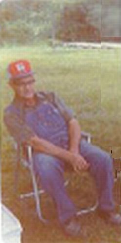
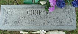
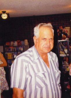
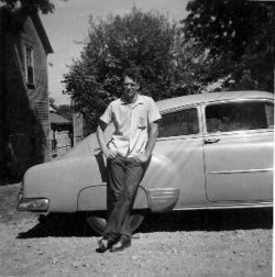
Mack Arnold Cooper
| Birth | : | 23 Oct 1905 Missouri, USA |
| Death | : | 15 Mar 1984 Mountain View, Howell County, Missouri, USA |
| Burial | : | Blackley Cemetery and Crematorium, Blackley, Metropolitan Borough of Manchester, England |
| Coordinate | : | 53.5333176, -2.2394190 |
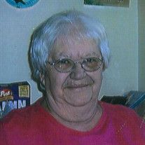
| Description | : | Mack Arnold Cooper was born on October 23, 1905 at red Bird, Missouri, the son of John and Isabell Wells Cooper; and departed this life on March 15, 1984 at the St. Francis Hospital in Mountain View, MO., at the age of 78 years He was married to Dona Derryberry on April 25, 1926 at Eminence, Mo. To this union eight children were born. He is survived by his wife Dona of the home in Birch Tree, Mo; four daughters; Norma Jean Pohl of St. James, Mo., Rosa Lee Nix of DeQueen, Ark., Juanita Wood of Birch Tree, Mo., and Pearl Etherton... Read More |
frequently asked questions (FAQ):
-
Where is Mack Arnold Cooper's memorial?
Mack Arnold Cooper's memorial is located at: Blackley Cemetery and Crematorium, Blackley, Metropolitan Borough of Manchester, England.
-
When did Mack Arnold Cooper death?
Mack Arnold Cooper death on 15 Mar 1984 in Mountain View, Howell County, Missouri, USA
-
Where are the coordinates of the Mack Arnold Cooper's memorial?
Latitude: 53.5333176
Longitude: -2.2394190
Family Members:
Parent
Spouse
Siblings


Children


Nearby Cemetories:
1. Blackley Cemetery and Crematorium
Blackley, Metropolitan Borough of Manchester, England
Coordinate: 53.5333176, -2.2394190
2. All Saints Churchyard Rhodes
Middleton, Metropolitan Borough of Rochdale, England
Coordinate: 53.5437200, -2.2261400
3. Blackley Presbyterian Chapel Chapelyard
Blackley, Metropolitan Borough of Manchester, England
Coordinate: 53.5233100, -2.2248110
4. St. Peter's Churchyard
Blackley, Metropolitan Borough of Manchester, England
Coordinate: 53.5231200, -2.2188900
5. Blackley Jewish Cemetery
Blackley, Metropolitan Borough of Manchester, England
Coordinate: 53.5299377, -2.2097650
6. Wesleyan Methodist Cemetery
Crumpsall, Metropolitan Borough of Manchester, England
Coordinate: 53.5142870, -2.2447610
7. Crumpsall Jewish Cemetery
Crumpsall, Metropolitan Borough of Manchester, England
Coordinate: 53.5124250, -2.2280270
8. St. Marks' Churchyard
Cheetham Hill, Metropolitan Borough of Manchester, England
Coordinate: 53.5113780, -2.2462660
9. Christchurch Harpurhey Churchyard
Harpurhey, Metropolitan Borough of Manchester, England
Coordinate: 53.5115100, -2.2134800
10. Great Synagogue Cemetery
Prestwich, Metropolitan Borough of Bury, England
Coordinate: 53.5315510, -2.2845730
11. St Paul's Churchyard
Salford, Metropolitan Borough of Salford, England
Coordinate: 53.5148800, -2.2725500
12. St. Mary the Virgin Churchyard
Prestwich, Metropolitan Borough of Bury, England
Coordinate: 53.5294033, -2.2864891
13. St Luke's Churchyard
Cheetham Hill, Metropolitan Borough of Manchester, England
Coordinate: 53.5041660, -2.2354680
14. Manchester General Cemetery
Manchester, Metropolitan Borough of Manchester, England
Coordinate: 53.5062710, -2.2179570
15. St. Michael's Churchyard
Middleton, Metropolitan Borough of Rochdale, England
Coordinate: 53.5476600, -2.1907240
16. Manchester Reform Jewish Old Cemetery
Whitefield, Metropolitan Borough of Bury, England
Coordinate: 53.5442728, -2.2918894
17. St Leonard's Churchyard
Middleton, Metropolitan Borough of Rochdale, England
Coordinate: 53.5530640, -2.1945060
18. Old Burial Grounds
Middleton, Metropolitan Borough of Rochdale, England
Coordinate: 53.5534036, -2.1948053
19. Rainsough Jewish Cemetery
Prestwich, Metropolitan Borough of Bury, England
Coordinate: 53.5185530, -2.2906950
20. St. Mary's Churchyard Birch-In-Hopwood
Heywood, Metropolitan Borough of Rochdale, England
Coordinate: 53.5662410, -2.2247560
21. St. Joseph's Roman Catholic Churchyard
Moston, Metropolitan Borough of Manchester, England
Coordinate: 53.5149270, -2.1877070
22. All Saints Churchyard Stand
Whitefield, Metropolitan Borough of Bury, England
Coordinate: 53.5501180, -2.2985570
23. Unsworth Weslyan Methodist Churchyard
Bury, Metropolitan Borough of Bury, England
Coordinate: 53.5667900, -2.2745100
24. St Georges Churchyard
Unsworth, Metropolitan Borough of Bury, England
Coordinate: 53.5668741, -2.2745340