

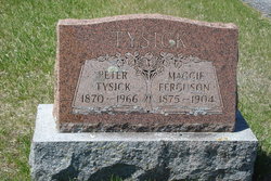
Maggie Ferguson Tysick
| Birth | : | 1875 |
| Death | : | 1904 |
| Burial | : | Spring Road Cemetery, Abingdon, Vale of White Horse District, England |
| Coordinate | : | 51.6722620, -1.2951410 |
| Plot | : | 194 |
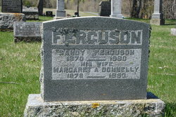
| Description | : | Plot 194 : - Peter Tysick 1870-1966. - his wife, Maggie Ferguson 1875-1904. |
frequently asked questions (FAQ):
-
Where is Maggie Ferguson Tysick's memorial?
Maggie Ferguson Tysick's memorial is located at: Spring Road Cemetery, Abingdon, Vale of White Horse District, England.
-
When did Maggie Ferguson Tysick death?
Maggie Ferguson Tysick death on 1904 in
-
Where are the coordinates of the Maggie Ferguson Tysick's memorial?
Latitude: 51.6722620
Longitude: -1.2951410
Family Members:
Parent

Spouse
Siblings

Children
Flowers:


Nearby Cemetories:
1. Spring Road Cemetery
Abingdon, Vale of White Horse District, England
Coordinate: 51.6722620, -1.2951410
2. Spring Garden Cemetery
Abingdon, Vale of White Horse District, England
Coordinate: 51.6750410, -1.2970850
3. Abingdon Baptist Church Burial Ground
Abingdon, Vale of White Horse District, England
Coordinate: 51.6700100, -1.2870810
4. Abingdon War Memorial
Abingdon, Vale of White Horse District, England
Coordinate: 51.6702940, -1.2839070
5. St. Helen's Churchyard
Abingdon, Vale of White Horse District, England
Coordinate: 51.6672868, -1.2830793
6. St Nicholas Church
Abingdon, Vale of White Horse District, England
Coordinate: 51.6702720, -1.2808640
7. St. Mary Magdalene Churchyard
Shippon, Vale of White Horse District, England
Coordinate: 51.6788360, -1.3060940
8. Abingdon Abbey (Defunct)
Abingdon, Vale of White Horse District, England
Coordinate: 51.6704790, -1.2783620
9. Our Lady and St Edmund of Abingdon Roman Catholic
Abingdon, Vale of White Horse District, England
Coordinate: 51.6747940, -1.2776270
10. St. Paul's Churchyard
Culham, South Oxfordshire District, England
Coordinate: 51.6512320, -1.2762060
11. Drayton Burial Ground
Drayton, Vale of White Horse District, England
Coordinate: 51.6443618, -1.3055533
12. St Peter Churchyard
Drayton, Vale of White Horse District, England
Coordinate: 51.6440000, -1.3070340
13. St. Peter Churchyard Extension
Drayton, Vale of White Horse District, England
Coordinate: 51.6440300, -1.3073700
14. St Leonard's Churchyard
Sunningwell, Vale of White Horse District, England
Coordinate: 51.7013600, -1.2840500
15. All Saints Churchyard
Sutton Courtenay, Vale of White Horse District, England
Coordinate: 51.6442680, -1.2718070
16. St. Helen Churchyard
Dry Sandford, Vale of White Horse District, England
Coordinate: 51.7003000, -1.3247100
17. All Saints Churchyard
Marcham, Vale of White Horse District, England
Coordinate: 51.6676980, -1.3496990
18. Sutton Courtenay Village Cemetery
Sutton Courtenay, Vale of White Horse District, England
Coordinate: 51.6394000, -1.2746000
19. St. James the Great Churchyard
Radley, Vale of White Horse District, England
Coordinate: 51.6907270, -1.2462510
20. Radley Cemetery
Radley, Vale of White Horse District, England
Coordinate: 51.6893900, -1.2446800
21. St Peter's Churchyard
Wootton, Vale of White Horse District, England
Coordinate: 51.7091400, -1.3118200
22. St Blaise Churchyard
Milton, Vale of White Horse District, England
Coordinate: 51.6284810, -1.3003670
23. Saint Lawrence Churchyard
Bessels Leigh, Vale of White Horse District, England
Coordinate: 51.7065220, -1.3409750
24. Kennington Cemetery
Kennington, Vale of White Horse District, England
Coordinate: 51.7055400, -1.2397800