
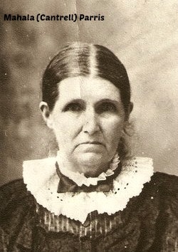

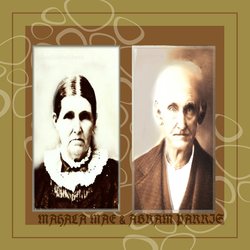
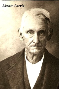
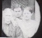
Mahala Mae “Haley” Cantrell Parris
| Birth | : | 22 Jan 1830 Spartanburg County, South Carolina, USA |
| Death | : | 23 Sep 1909 Grainger County, Tennessee, USA |
| Burial | : | Harmony Baptist Church Cemetery, Edgemoor, Chester County, USA |
| Coordinate | : | 34.8046250, -80.9690760 |
| Description | : | "Haley" was the daughter of John Hightower & Elizabeth (Parris) Cantrell. She married, Abram Parris, in 1846, in Spartanburg County, South Carolina. They lived on the banks of Buck Creek and attended the Buck Creek Baptist Church. Before 1860 they moved into Polk County NC. They were on the move again, after Abram was wounded and discharged from the Civil War, when they crossed the mountians into Tennessee. They lived for a short time in Hancock County. After the War ended they moved into Grainger County near Bean Station. Here,during reconstruction, she washed, ironed and mended shirts for the... Read More |
frequently asked questions (FAQ):
-
Where is Mahala Mae “Haley” Cantrell Parris's memorial?
Mahala Mae “Haley” Cantrell Parris's memorial is located at: Harmony Baptist Church Cemetery, Edgemoor, Chester County, USA.
-
When did Mahala Mae “Haley” Cantrell Parris death?
Mahala Mae “Haley” Cantrell Parris death on 23 Sep 1909 in Grainger County, Tennessee, USA
-
Where are the coordinates of the Mahala Mae “Haley” Cantrell Parris's memorial?
Latitude: 34.8046250
Longitude: -80.9690760
Family Members:
Parent
Spouse
Siblings

Children
Flowers:


Nearby Cemetories:
1. Harmony Baptist Church Cemetery
Edgemoor, Chester County, USA
Coordinate: 34.8046250, -80.9690760
2. Rives Family Burying Grounds
Edgemoor, Chester County, USA
Coordinate: 34.7990600, -80.9970000
3. Bethel United Methodist Church Cemetery
Edgemoor, Chester County, USA
Coordinate: 34.7921600, -80.9321100
4. Big Calvary Baptist Church Cemetery
Edgemoor, Chester County, USA
Coordinate: 34.7882180, -81.0050820
5. Edgemoor ARP Church Cemetery
Edgemoor, Chester County, USA
Coordinate: 34.8055800, -81.0104000
6. Liberty Hill Baptist Church Cemetery
Catawba, York County, USA
Coordinate: 34.8286660, -80.9384350
7. Red Oak AME Zion Church Cemetery
Edgemoor, Chester County, USA
Coordinate: 34.8019210, -81.0123740
8. Mount Calvary AME Zion Church Cemetery
Rock Hill, York County, USA
Coordinate: 34.8445778, -80.9860687
9. New Covenant Church
Chester County, USA
Coordinate: 34.7818130, -80.9198320
10. Lando Cemetery
Lando, Chester County, USA
Coordinate: 34.7717300, -81.0102260
11. Nichols Family Cemetery
Edgemoor, Chester County, USA
Coordinate: 34.7734860, -80.9251110
12. Mount Zion AME Zion Church Cemetery
Landsford, Chester County, USA
Coordinate: 34.7743200, -80.9175800
13. Old Stone Cemetery
Fort Lawn, Chester County, USA
Coordinate: 34.7905870, -80.9053250
14. New Vision Freewill Baptist Church Cemetery
Rock Hill, York County, USA
Coordinate: 34.8520660, -81.0023010
15. Burnt Meeting House Church Cemetery
Chester County, USA
Coordinate: 34.7440000, -80.9765300
16. Catawba Chapel A.M.E. Zion Church Cemetery
Catawba, York County, USA
Coordinate: 34.8555500, -80.9262500
17. Neely's Creek ARP Church Cemetery
Rock Hill, York County, USA
Coordinate: 34.8673260, -80.9651080
18. Mount Vernon AME Zion Church Cemetery
Chester County, USA
Coordinate: 34.7422210, -80.9603680
19. Catawba Methodist Church Cemetery
Catawba, York County, USA
Coordinate: 34.8506851, -80.9131012
20. El Bethel United Methodist Church Cemetery
Chester County, USA
Coordinate: 34.7513590, -80.9194850
21. Mount Holly United Methodist Church Cemetery
Rock Hill, York County, USA
Coordinate: 34.8674278, -81.0165024
22. Pleasant Ridge Baptist Church Cemetery
Rock Hill, York County, USA
Coordinate: 34.8530235, -81.0420914
23. Tabernacle AME Zion Church Cemetery
Rock Hill, York County, USA
Coordinate: 34.8749847, -80.9308090
24. Hopewell Presbyterian Church Cemetery
Lesslie, York County, USA
Coordinate: 34.8835320, -80.9648800