
| Birth | : | 19 Jul 1867 Shelburne, Shelburne County, Nova Scotia, Canada |
| Death | : | 31 Oct 1916 Boston, Suffolk County, Massachusetts, USA |
| Burial | : | Roseway Cemetery, Roseway, Shelburne County, Canada |
| Coordinate | : | 43.6239909, -65.3501101 |
| Inscription | : | In loving memory Makaska A Hagar In a collision with the Camden and schooner Arthur James in Castle Island Channel, Boston Harbour. Look for the unexpected |
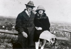
| Description | : | Makaska was born in Round Bay, Shelburne County, Nova Scotia. He was the son of Amos Hagar and Margaret D. Swaine. He was married to Annie Perry Hagar on Feb. 19, 1896 in Round Bay. They had six children: Clyde, Orison, William, Selina Violetta, Glen, and Frances Oleta. He was a cook on the fishing schooner, Arthur James. He was killed in Boston Harbor when the Arthur James, was hit by the Camden and sunk in 50 feet of water. He was the only casualty. Orison, his 17 year-old son, was also on the vessel. |
frequently asked questions (FAQ):
-
Where is Makaska Abiel Amos Hagar's memorial?
Makaska Abiel Amos Hagar's memorial is located at: Roseway Cemetery, Roseway, Shelburne County, Canada.
-
When did Makaska Abiel Amos Hagar death?
Makaska Abiel Amos Hagar death on 31 Oct 1916 in Boston, Suffolk County, Massachusetts, USA
-
Where are the coordinates of the Makaska Abiel Amos Hagar's memorial?
Latitude: 43.6239909
Longitude: -65.3501101
Family Members:
Parent

Spouse
Siblings
Children
Flowers:


Nearby Cemetories:
1. Roseway Cemetery
Roseway, Shelburne County, Canada
Coordinate: 43.6239909, -65.3501101
2. Ingomar Community Cemetery
Ingomar, Shelburne County, Canada
Coordinate: 43.5730968, -65.3581679
3. Dall Cemetery
Lower Sandy Point, Shelburne County, Canada
Coordinate: 43.6730720, -65.2881470
4. Harbour View Cemetery
Port Saxon, Shelburne County, Canada
Coordinate: 43.5866700, -65.4284730
5. Pleasant Plain Cemetery
North West Harbour, Shelburne County, Canada
Coordinate: 43.5496673, -65.3979585
6. Old Kirk Cemetery
North East Point, Shelburne County, Canada
Coordinate: 43.5491240, -65.3982850
7. Port Clyde Cemetery
Port Clyde, Shelburne County, Canada
Coordinate: 43.5944429, -65.4657523
8. Anglican Cemetery
Churchover, Shelburne County, Canada
Coordinate: 43.7142400, -65.3595400
9. Saint Matthews Cemetery
Clyde River, Shelburne County, Canada
Coordinate: 43.6319900, -65.4779200
10. Seaview Cemetery
Cape Negro, Shelburne County, Canada
Coordinate: 43.5540850, -65.4438020
11. Hillside Cemetery
Cape Negro, Shelburne County, Canada
Coordinate: 43.5563700, -65.4534960
12. Mizpah Cemetery
Birchtown, Shelburne County, Canada
Coordinate: 43.7382800, -65.3892000
13. Black Burial Ground
Birchtown, Shelburne County, Canada
Coordinate: 43.7449600, -65.3797700
14. Parkdale Cemetery
Upper Port La Tour, Shelburne County, Canada
Coordinate: 43.5156570, -65.4655722
15. Christ Church Cemetery
Shelburne, Shelburne County, Canada
Coordinate: 43.7609600, -65.3195000
16. Shelburne Methodist Church Cemetery
Shelburne, Shelburne County, Canada
Coordinate: 43.7621170, -65.3201620
17. Saint John's Kirkyard Cemetery
Shelburne, Shelburne County, Canada
Coordinate: 43.7628460, -65.3200420
18. Scott Memorial Cemetery
West Green Harbour, Shelburne County, Canada
Coordinate: 43.7084170, -65.1831410
19. Pine Grove Cemetery
Shelburne, Shelburne County, Canada
Coordinate: 43.7716657, -65.3145776
20. Camp Hill Cemetery
Port La Tour, Shelburne County, Canada
Coordinate: 43.5033050, -65.4845240
21. Villagedale Cemetery
Villagedale, Shelburne County, Canada
Coordinate: 43.5379720, -65.5476840
22. Ponds Cemetery
Port La Tour, Shelburne County, Canada
Coordinate: 43.4977020, -65.5054660
23. Smithsville Union Cemetery
Smithsville, Shelburne County, Canada
Coordinate: 43.4791670, -65.4738890
24. Barrington River Cemetery
Barrington, Shelburne County, Canada
Coordinate: 43.5667700, -65.5797000