
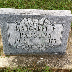
Margaret Ellen Piatt Parsons
| Birth | : | 2 Mar 1916 Carroll County, Indiana, USA |
| Death | : | 1 Mar 1979 Monticello, White County, Indiana, USA |
| Burial | : | Saint Catherine Cemetery, DuBois, Clearfield County, USA |
| Coordinate | : | 41.1218987, -78.7782974 |
| Description | : | MONTICELLO — Margaret E. Parsons, 62, Monticello, died at 11:15 a.m. Thursday at the Monticello Community Health Care Center following an extended illness. Born March 2. 1916, in Carroll County, she was the daughter of Theodore 0. and Rhoda E. Moore Piatt. She was married Dec. 28, 1945, to George W. Parsons, who preceded her in death. A resident of the Monticello community most of her life, she had also resided in Chicago, Ill.; and California. She was a member of the Assembly Of God Church. Surviving are one son, George Michael, College Park, Md..; two brothers, Donald J., Santa Clara, Calif.; and... Read More |
frequently asked questions (FAQ):
-
Where is Margaret Ellen Piatt Parsons's memorial?
Margaret Ellen Piatt Parsons's memorial is located at: Saint Catherine Cemetery, DuBois, Clearfield County, USA.
-
When did Margaret Ellen Piatt Parsons death?
Margaret Ellen Piatt Parsons death on 1 Mar 1979 in Monticello, White County, Indiana, USA
-
Where are the coordinates of the Margaret Ellen Piatt Parsons's memorial?
Latitude: 41.1218987
Longitude: -78.7782974
Family Members:
Parent

Siblings
Flowers:


Nearby Cemetories:
1. Saint Catherine Cemetery
DuBois, Clearfield County, USA
Coordinate: 41.1218987, -78.7782974
2. Sons of Israel Cemetery
DuBois, Clearfield County, USA
Coordinate: 41.1228250, -78.7792960
3. Saint Josephs Cemetery
DuBois, Clearfield County, USA
Coordinate: 41.1227989, -78.7822037
4. Saint Michaels Cemetery
DuBois, Clearfield County, USA
Coordinate: 41.1227989, -78.7855988
5. Rumbarger Cemetery
DuBois, Clearfield County, USA
Coordinate: 41.1157990, -78.7742004
6. Wayne Cemetery
Sandy Township, Clearfield County, USA
Coordinate: 41.1068860, -78.7934230
7. John DuBois Monument
DuBois, Clearfield County, USA
Coordinate: 41.1288240, -78.7515390
8. Taylor Cemetery
Falls Creek, Jefferson County, USA
Coordinate: 41.1409683, -78.8108292
9. Oklahoma Cemetery
Clearfield County, USA
Coordinate: 41.1142000, -78.7318000
10. Greenwood Cemetery
DuBois, Clearfield County, USA
Coordinate: 41.1502991, -78.7485962
11. West Liberty Cemetery
DuBois, Clearfield County, USA
Coordinate: 41.0802400, -78.7836300
12. Morningside Cemetery
DuBois, Clearfield County, USA
Coordinate: 41.1255989, -78.7208023
13. Old West Liberty Cemetery
DuBois, Clearfield County, USA
Coordinate: 41.0775100, -78.7871900
14. Delarme Cemetery
Winslow, Jefferson County, USA
Coordinate: 41.0818000, -78.8107000
15. Salem Methodist Cemetery
DuBois, Clearfield County, USA
Coordinate: 41.0747000, -78.7459000
16. Prospect Cemetery
Reynoldsville, Jefferson County, USA
Coordinate: 41.0839005, -78.8377991
17. Fuller Cemetery
Reynoldsville, Jefferson County, USA
Coordinate: 41.0867120, -78.8582660
18. Mix Family Burial Ground
Reynoldsville, Jefferson County, USA
Coordinate: 41.0797710, -78.8529170
19. Sandy Valley Cemetery
Sandy Valley, Jefferson County, USA
Coordinate: 41.1261000, -78.8779000
20. Holy Trinity Byzantine Catholic Cemetery
Sykesville, Jefferson County, USA
Coordinate: 41.0536003, -78.8268967
21. Beulah Land Cemetery
Reynoldsville, Jefferson County, USA
Coordinate: 41.0931015, -78.8743973
22. Baptist Cemetery
Winslow Township, Jefferson County, USA
Coordinate: 41.0897484, -78.8731155
23. Luthersburg Union Cemetery
Luthersburg, Clearfield County, USA
Coordinate: 41.0547485, -78.7234497
24. Assumption Cemetery
Sykesville, Jefferson County, USA
Coordinate: 41.0550000, -78.8354000