
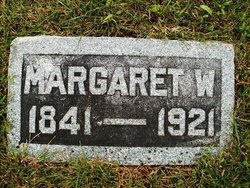
Margaret Shepherd Wishart Miller
| Birth | : | 7 Nov 1836 Macduff, Aberdeenshire, Scotland |
| Death | : | 15 Jun 1921 Pawnee City, Pawnee County, Nebraska, USA |
| Burial | : | Union Chapel, Combe Down, Bath and North East Somerset Unitary Authority, England |
| Coordinate | : | 51.3594751, -2.3443662 |
| Plot | : | Orig. 92 1/2- 1 |
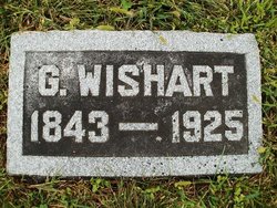
| Description | : | Married to George Wishart Miller Jan. 19, 1872 in Scotland. (Posted courtesy of the Table Rock Historical Society.) Table Rock Argus, July 1, 1921. Mrs. Margaret Miller. Mrs. Margaret Miller died at her home in Pawnee City, Nebraska, June 15, 1921. She was born and grew to womanhood in Scotland, where she was married to G. Wishart Miller in 1872. They came to Pawnee county in the summer of 1874. They bought a farm near Pawnee City and at once identified themselves with the United Presbyterian church. To them were born three children: Mary Elizabeth McQuiston, of Scotch Ridge, Ohio; Margaret, who died in... Read More |
frequently asked questions (FAQ):
-
Where is Margaret Shepherd Wishart Miller's memorial?
Margaret Shepherd Wishart Miller's memorial is located at: Union Chapel, Combe Down, Bath and North East Somerset Unitary Authority, England.
-
When did Margaret Shepherd Wishart Miller death?
Margaret Shepherd Wishart Miller death on 15 Jun 1921 in Pawnee City, Pawnee County, Nebraska, USA
-
Where are the coordinates of the Margaret Shepherd Wishart Miller's memorial?
Latitude: 51.3594751
Longitude: -2.3443662
Family Members:
Parent
Spouse
Siblings

Children
Flowers:


Nearby Cemetories:
1. Union Chapel
Combe Down, Bath and North East Somerset Unitary Authority, England
Coordinate: 51.3594751, -2.3443662
2. Prior Park College
Bath, Bath and North East Somerset Unitary Authority, England
Coordinate: 51.3645990, -2.3442400
3. Jewish Burial Ground
Combe Down, Bath and North East Somerset Unitary Authority, England
Coordinate: 51.3599170, -2.3534670
4. St. Michael's Churchyard
Monkton Combe, Bath and North East Somerset Unitary Authority, England
Coordinate: 51.3559540, -2.3285700
5. St John the Evangelist Cemetery
Bath, Bath and North East Somerset Unitary Authority, England
Coordinate: 51.3696700, -2.3487400
6. Bath Abbey Cemetery
Widcombe, Bath and North East Somerset Unitary Authority, England
Coordinate: 51.3712850, -2.3483060
7. Unitarian Chapel Burial Ground
Widcombe, Bath and North East Somerset Unitary Authority, England
Coordinate: 51.3704650, -2.3539270
8. St Thomas à Becket's Church
Widcombe, Bath and North East Somerset Unitary Authority, England
Coordinate: 51.3734250, -2.3465560
9. Quaker Burial Ground
Widcombe, Bath and North East Somerset Unitary Authority, England
Coordinate: 51.3744350, -2.3498460
10. Smallcombe Vale Cemetery
Bathwick, Bath and North East Somerset Unitary Authority, England
Coordinate: 51.3757400, -2.3429400
11. St. James' Churchyard
South Stoke, Bath and North East Somerset Unitary Authority, England
Coordinate: 51.3497220, -2.3652780
12. St. Mary The Virgin Churchyard
Bathwick, Bath and North East Somerset Unitary Authority, England
Coordinate: 51.3759930, -2.3411930
13. Bath Union Workhouse Graveyard
Bath, Bath and North East Somerset Unitary Authority, England
Coordinate: 51.3584160, -2.3711140
14. Abbey & St James' Graveyard for the Poor
Widcombe, Bath and North East Somerset Unitary Authority, England
Coordinate: 51.3753550, -2.3545640
15. Old Baptist Burial Ground
Walcot, Bath and North East Somerset Unitary Authority, England
Coordinate: 51.3755070, -2.3544360
16. Baptist Burial Ground
Widcombe, Bath and North East Somerset Unitary Authority, England
Coordinate: 51.3764216, -2.3556947
17. Saint Mark's Churchyard
Widcombe, Bath and North East Somerset Unitary Authority, England
Coordinate: 51.3766660, -2.3588010
18. Midford Burial Ground
Bath, Bath and North East Somerset Unitary Authority, England
Coordinate: 51.3394360, -2.3391424
19. Bath Union Workhouse Burial Ground
Bath, Bath and North East Somerset Unitary Authority, England
Coordinate: 51.3570889, -2.3773370
20. St Mary Magdalen Chapel
Widcombe, Bath and North East Somerset Unitary Authority, England
Coordinate: 51.3760486, -2.3643405
21. Old Orchard Street Catholic Burial Vault
Bath, Bath and North East Somerset Unitary Authority, England
Coordinate: 51.3800370, -2.3579910
22. St James Old Burial Ground
Bath, Bath and North East Somerset Unitary Authority, England
Coordinate: 51.3798600, -2.3610100
23. Bath Abbey
Bath, Bath and North East Somerset Unitary Authority, England
Coordinate: 51.3815310, -2.3586640
24. St. Mary de Stall Churchyard (Defunct)
Bath, Bath and North East Somerset Unitary Authority, England
Coordinate: 51.3813350, -2.3600353