
| Birth | : | 22 Apr 1808 Soledad, Monterey County, California, USA |
| Death | : | Jan 1852 Monterey, Monterey County, California, USA |
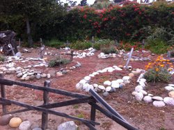
| Burial | : | San Carlos Cemetery, Monterey, Monterey County, USA |
| Coordinate | : | 36.5951881, -121.8871460 |
| Description | : | María Concepción Sotera Amésquita y Camacho was born at Mission Soledad on April 22, 1808, where she was baptized later that same day in the mission chapel (SLD Baptism 01320). She was the daughter of José Amésquita and Josefa Camacho. She married soldado José Antonio Alvitre y Hernández at Mission San Juan Bautista July 27, 1823 (SJB Marriage 00835). María died at Monterey where she was buried in the San Carlos Cemetery on January 31, 1852 (SC Death 03477). |
frequently asked questions (FAQ):
-
Where is Maria Concepcion Sotera Amesquita Alvitre's memorial?
Maria Concepcion Sotera Amesquita Alvitre's memorial is located at: San Carlos Cemetery, Monterey, Monterey County, USA.
-
When did Maria Concepcion Sotera Amesquita Alvitre death?
Maria Concepcion Sotera Amesquita Alvitre death on Jan 1852 in Monterey, Monterey County, California, USA
-
Where are the coordinates of the Maria Concepcion Sotera Amesquita Alvitre's memorial?
Latitude: 36.5951881
Longitude: -121.8871460
Family Members:
Parent
Spouse

Siblings
Children


Nearby Cemetories:
1. San Carlos Cemetery
Monterey, Monterey County, USA
Coordinate: 36.5951881, -121.8871460
2. Monterey City Cemetery
Monterey, Monterey County, USA
Coordinate: 36.5954475, -121.8845215
3. Mission San Carlos Cemetery
Monterey, Monterey County, USA
Coordinate: 36.5956078, -121.8904190
4. Alexis Nino Burial Site
Monterey, Monterey County, USA
Coordinate: 36.6055565, -121.8955307
5. Presidio of Monterey Cemetery
Monterey, Monterey County, USA
Coordinate: 36.6058006, -121.9151306
6. Steinbeck Estate Burial Site
Pacific Grove, Monterey County, USA
Coordinate: 36.6197319, -121.9080276
7. Saint Mary's Episcopal Church Leslie Garden
Pacific Grove, Monterey County, USA
Coordinate: 36.6211200, -121.9145800
8. City of Carmel Memorials
Carmel-by-the-Sea, Monterey County, USA
Coordinate: 36.5552979, -121.9203339
9. El Carmelo Cemetery
Pacific Grove, Monterey County, USA
Coordinate: 36.6325836, -121.9319763
10. Mission Memorial Park
Seaside, Monterey County, USA
Coordinate: 36.6191635, -121.8217926
11. Carmel Mission Cemetery
Carmel-by-the-Sea, Monterey County, USA
Coordinate: 36.5430603, -121.9199600
12. Carmelite Monastery Cemetery
Monterey, Monterey County, USA
Coordinate: 36.5231400, -121.9232635
13. California Central Coast Veterans Cemetery
Seaside, Monterey County, USA
Coordinate: 36.6371900, -121.7963600
14. Saint Dunstans Episcopal Church Columbarium
Carmel Valley, Monterey County, USA
Coordinate: 36.5197330, -121.8059160
15. Whitcher Cemetery
East Garrison, Monterey County, USA
Coordinate: 36.6501730, -121.7305270
16. Church of the Good Shepherd Cemetery
Salinas, Monterey County, USA
Coordinate: 36.5413990, -121.7260410
17. Calvary Catholic Cemetery
Salinas, Monterey County, USA
Coordinate: 36.6880341, -121.6818085
18. Saint Pauls Episcopal Church Columbarium
Salinas, Monterey County, USA
Coordinate: 36.6588430, -121.6558850
19. Garden of Memories
Salinas, Monterey County, USA
Coordinate: 36.6565247, -121.6384125
20. Castroville Public Cemetery
Moss Landing, Monterey County, USA
Coordinate: 36.7930145, -121.7851410
21. Yamato Cemetery
Salinas, Monterey County, USA
Coordinate: 36.6552811, -121.6307297
22. Chinese Cemetery
Salinas, Monterey County, USA
Coordinate: 36.6952057, -121.6390381
23. Monterey County Potters Field Cemetery
Salinas, Monterey County, USA
Coordinate: 36.6960900, -121.6381950
24. Saint Georges Episcopal Church Columbarium
Salinas, Monterey County, USA
Coordinate: 36.7062580, -121.6440980