
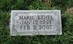
Marie E Brant
| Birth | : | 12 Jan 1927 |
| Death | : | 2 Feb 2007 |
| Burial | : | St. Mary's Churchyard, Denton, South Norfolk District, England |
| Coordinate | : | 52.4364500, 1.3618770 |
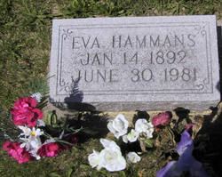
| Description | : | Marie E. Brant, 80, of Truro died Feb. 2, 2007, at Iowa Methodist Medical Center in Des Moines. Marie Brant was born Jan. 12, 1927, to John Erven and Ruth Eva (Hammans) Brant of rural Truro. She received her education from the Oak Run Country School in Madison County and Truro High School, graduating in 1944. Following graduation, she attended Omaha Business College. Marie was employed for a short time at Union State Bank in Truro before starting her lifelong career at the Natural Gas Pipeline Company (NGPL) in rural Truro, retiring in 1992. While working at Natural Gas Pipeline,... Read More |
frequently asked questions (FAQ):
-
Where is Marie E Brant's memorial?
Marie E Brant's memorial is located at: St. Mary's Churchyard, Denton, South Norfolk District, England.
-
When did Marie E Brant death?
Marie E Brant death on 2 Feb 2007 in
-
Where are the coordinates of the Marie E Brant's memorial?
Latitude: 52.4364500
Longitude: 1.3618770
Family Members:
Parent
Siblings

Flowers:


Nearby Cemetories:
1. St. Mary's Churchyard
Denton, South Norfolk District, England
Coordinate: 52.4364500, 1.3618770
2. United Reformed Churchyard
Denton, South Norfolk District, England
Coordinate: 52.4465510, 1.3532090
3. All Saints Churchyard
Alburgh, South Norfolk District, England
Coordinate: 52.4362610, 1.3386490
4. Saint Mary Churchyard
Homersfield, Waveney District, England
Coordinate: 52.4191670, 1.3595410
5. St. Mary Churchyard
Flixton (West), Waveney District, England
Coordinate: 52.4292500, 1.3995130
6. Flixton Abbey
Flixton (West), Waveney District, England
Coordinate: 52.4292800, 1.3996050
7. St George's Churchyard
South Elmham St Cross, Waveney District, England
Coordinate: 52.4080410, 1.3794272
8. Church of the Assumption of the Blessed Virgin Mar
Redenhall, South Norfolk District, England
Coordinate: 52.4104780, 1.3272680
9. All Saints Churchyard
Earsham, South Norfolk District, England
Coordinate: 52.4480480, 1.4212330
10. St. Margaret's Churchyard
South Elmham St Margaret, Waveney District, England
Coordinate: 52.4047900, 1.4007730
11. All Saints Churchyard
Mendham, Mid Suffolk District, England
Coordinate: 52.3976310, 1.3349670
12. Emmanuel Church Cemetery
Bungay, Waveney District, England
Coordinate: 52.4526800, 1.4382410
13. St. Mary's Churchyard and Priory
Bungay, Waveney District, England
Coordinate: 52.4555100, 1.4375800
14. St Edmunds RC Churchyard
Bungay, Waveney District, England
Coordinate: 52.4550570, 1.4381220
15. St. Peter's Churchyard
Waveney District, England
Coordinate: 52.4114350, 1.4333280
16. Holy Trinity Churchyard
Bungay, Waveney District, England
Coordinate: 52.4553310, 1.4399650
17. Bungay Cemetery
Bungay, Waveney District, England
Coordinate: 52.4475475, 1.4444244
18. Saint Andrews Churchyard
Bedingham, South Norfolk District, England
Coordinate: 52.4902500, 1.3643180
19. All Saints Churchyard
South Elmham St Nicholas, Waveney District, England
Coordinate: 52.3936690, 1.4226680
20. St. Mary's Churchyard
Ditchingham, South Norfolk District, England
Coordinate: 52.4776358, 1.4282946
21. St. Michael's Churchyard
South Elmham St Michael, Waveney District, England
Coordinate: 52.4033450, 1.4406520
22. St. Peter's Churchyard
Hedenham, South Norfolk District, England
Coordinate: 52.4891780, 1.4041660
23. Saint Mary Magdalene Churchyard
Metfield, Mid Suffolk District, England
Coordinate: 52.3773540, 1.3538467
24. Ditchingham Cemetery
Ditchingham, South Norfolk District, England
Coordinate: 52.4793614, 1.4307304