
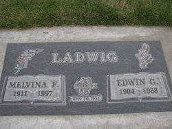
| Birth | : | 1904 |
| Death | : | 1990 Washington, USA |
| Burial | : | Kendall Cemetery, Moss, Clay County, USA |
| Coordinate | : | 36.5672540, -85.6362650 |
| Plot | : | 3-A 8 |
frequently asked questions (FAQ):
-
Where is Marie R. Hankel Powell's memorial?
Marie R. Hankel Powell's memorial is located at: Kendall Cemetery, Moss, Clay County, USA.
-
When did Marie R. Hankel Powell death?
Marie R. Hankel Powell death on 1990 in Washington, USA
-
Where are the coordinates of the Marie R. Hankel Powell's memorial?
Latitude: 36.5672540
Longitude: -85.6362650
Family Members:
Parent
Spouse

Siblings
Flowers:


Nearby Cemetories:
1. Kendall Cemetery
Moss, Clay County, USA
Coordinate: 36.5672540, -85.6362650
2. Eads-Denton Cemetery
Pine Hill, Clay County, USA
Coordinate: 36.5644207, -85.6503187
3. Smith Cemetery
Pine Hill, Clay County, USA
Coordinate: 36.5714930, -85.6568170
4. Macedonia Cemetery
Moss, Clay County, USA
Coordinate: 36.5643997, -85.6110992
5. Strong Family Cemetery
Clay County, USA
Coordinate: 36.5690700, -85.6042600
6. Moss Cemetery
Moss, Clay County, USA
Coordinate: 36.5911210, -85.6214460
7. McLerran Cemetery
Moss, Clay County, USA
Coordinate: 36.5790000, -85.5973000
8. Liberty Church Cemetery
Boles, Clay County, USA
Coordinate: 36.6010850, -85.6496830
9. Odle Cemetery
Clay County, USA
Coordinate: 36.5966988, -85.6085968
10. Pricetown Cemetery
Clay County, USA
Coordinate: 36.5422500, -85.6750670
11. Moore Cemetery
Moss, Clay County, USA
Coordinate: 36.6113400, -85.6374980
12. Jonestown Cemetery
Clay County, USA
Coordinate: 36.5619011, -85.6921997
13. Spear Family Cemetery
Moss, Clay County, USA
Coordinate: 36.5933200, -85.5876500
14. Meadows Cemetery
Clay County, USA
Coordinate: 36.5946999, -85.5875015
15. Willhoite-Curtis Cemetery
Tompkinsville, Monroe County, USA
Coordinate: 36.6182208, -85.6442948
16. Cherry Denton Cemetery
Clay County, USA
Coordinate: 36.5512200, -85.6971200
17. Hinson Cemetery
Moss, Clay County, USA
Coordinate: 36.5756750, -85.7020010
18. Moore Cemetery #1
Moss, Clay County, USA
Coordinate: 36.6164920, -85.6636620
19. Pitcock Cemetery
Clay County, USA
Coordinate: 36.5992012, -85.6911011
20. Freedom Cemetery #2
Tompkinsville, Monroe County, USA
Coordinate: 36.6284060, -85.6289940
21. Cherry Family Cemetery #02
Clay County, USA
Coordinate: 36.5071260, -85.6685290
22. Old Bob Wood Place Cemetery
Boles, Monroe County, USA
Coordinate: 36.6325120, -85.6515600
23. New Hope Cemetery
Clay County, USA
Coordinate: 36.6021996, -85.5653000
24. Cherry Cemetery #3
Oak Grove, Clay County, USA
Coordinate: 36.6015000, -85.7100300