
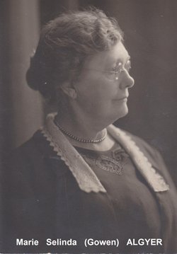

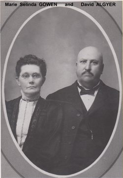
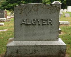
Marie Selinda Gowen Algyer
| Birth | : | 30 Oct 1848 Sanford, York County, Maine, USA |
| Death | : | 4 Feb 1932 Brookings, Brookings County, South Dakota, USA |
| Burial | : | Cleethorpes Cemetery, Cleethorpes, North East Lincolnshire Unitary Authority, England |
| Coordinate | : | 53.5553760, -0.0399990 |
| Plot | : | Lot C-217 |
| Description | : | Cause of death - Senility. Marie {Age 71; Widow} is recorded on the 1910 census at Woodbury, Iowa dwelling in the household of her daughter, Edith Epperson. Marie {Age 81; Widow} is recorded on the 1930 census at Decorah, Winneshiek, Iowa dwelling in the household of her son, Durwin. BROOKINGS REGISTER - February 1932: ********************************* Mrs. Marie Algyer, age 83, died in the home of her daughter, Mrs. John Raak on Sunday afternoon following an illness since last June. The body was sent to Decorah, Iowa on the east-bound train to-day and burial will be made there. |
frequently asked questions (FAQ):
-
Where is Marie Selinda Gowen Algyer's memorial?
Marie Selinda Gowen Algyer's memorial is located at: Cleethorpes Cemetery, Cleethorpes, North East Lincolnshire Unitary Authority, England.
-
When did Marie Selinda Gowen Algyer death?
Marie Selinda Gowen Algyer death on 4 Feb 1932 in Brookings, Brookings County, South Dakota, USA
-
Where are the coordinates of the Marie Selinda Gowen Algyer's memorial?
Latitude: 53.5553760
Longitude: -0.0399990
Family Members:
Parent

Spouse
Siblings
Children
Flowers:


Nearby Cemetories:
1. Cleethorpes Cemetery
Cleethorpes, North East Lincolnshire Unitary Authority, England
Coordinate: 53.5553760, -0.0399990
2. St Peter's Church
Cleethorpes, North East Lincolnshire Unitary Authority, England
Coordinate: 53.5579756, -0.0307081
3. Holy Trinity & St Mary the Virgin Churchyard
Grimsby, North East Lincolnshire Unitary Authority, England
Coordinate: 53.5569000, -0.0541000
4. Grimsby Crematorium
Grimsby, North East Lincolnshire Unitary Authority, England
Coordinate: 53.5466260, -0.0776350
5. St Peters Churchyard
Humberston, North East Lincolnshire Unitary Authority, England
Coordinate: 53.5278300, -0.0238300
6. Scartho Road Cemetery
Grimsby, North East Lincolnshire Unitary Authority, England
Coordinate: 53.5464940, -0.0885840
7. St. James Minster and Parish Church
Grimsby, North East Lincolnshire Unitary Authority, England
Coordinate: 53.5639670, -0.0893070
8. St. Giles Churchyard
Scartho, North East Lincolnshire Unitary Authority, England
Coordinate: 53.5384200, -0.0888130
9. Holton le Clay Cemetery
Holton le Clay, East Lindsey District, England
Coordinate: 53.5074170, -0.0592630
10. Waltham Cemetery
Waltham, North East Lincolnshire Unitary Authority, England
Coordinate: 53.5155500, -0.0934700
11. St Peters Churchyard
Holton le Clay, East Lindsey District, England
Coordinate: 53.5060368, -0.0616628
12. All Saints Churchyard
Waltham, North East Lincolnshire Unitary Authority, England
Coordinate: 53.5167000, -0.0986700
13. St Michael's Churchyard
Little Coates, North East Lincolnshire Unitary Authority, England
Coordinate: 53.5631770, -0.1274160
14. St Georges Churchyard
Bradley, North East Lincolnshire Unitary Authority, England
Coordinate: 53.5429000, -0.1275800
15. St Nicolas Churchyard
Great Coates, North East Lincolnshire Unitary Authority, England
Coordinate: 53.5701890, -0.1391100
16. St Helen's Churchyard
Brigsley, North East Lincolnshire Unitary Authority, England
Coordinate: 53.4982361, -0.1099315
17. St Peter's Churchyard
Ashby cum Fenby, North East Lincolnshire Unitary Authority, England
Coordinate: 53.4903100, -0.1105200
18. St Peter & St Paul
Healing, North East Lincolnshire Unitary Authority, England
Coordinate: 53.5734480, -0.1682390
19. Laceby Cemetery
Laceby, North East Lincolnshire Unitary Authority, England
Coordinate: 53.5411890, -0.1740470
20. St Nicholas Church
Grainsby, East Lindsey District, England
Coordinate: 53.4765150, -0.0755630
21. St Lawrence Churchyard
Aylesby, North East Lincolnshire Unitary Authority, England
Coordinate: 53.5511600, -0.1858320
22. St. Martin Churchyard
East Ravendale, North East Lincolnshire Unitary Authority, England
Coordinate: 53.4793000, -0.1370044
23. St. Lawrence's Churchyard
Fulstow, East Lindsey District, England
Coordinate: 53.4599000, -0.0070000
24. Ss Peter & Paul Churchyard
Stallingborough, North East Lincolnshire Unitary Authority, England
Coordinate: 53.5895280, -0.1960590