
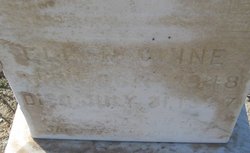
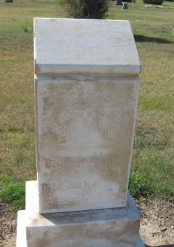
Marjorie Ellen Moriarty Cline
| Birth | : | 1 Oct 1848 Marion County, Ohio, USA |
| Death | : | 31 Jul 1927 Chouteau County, Montana, USA |
| Burial | : | Holy Trinity Churchyard, Newton St Loe, Bath and North East Somerset Unitary Authority, England |
| Coordinate | : | 51.3820470, -2.4311300 |
| Description | : | Obituary infro from Find A Grave contributor "Cara" Havre Daily News Promoter (MT), 3 Aug 1927 Mrs. Marjorie Ellen Kline, age 78, died at the residence of her son five miles east of Big Sandy, Sunday, July 31. Mrs. Kline was born in Marion county, Ohio, Oct. 1, 1848, and from there moved to Boone county, Iowa, where she married S.G. Kline on Feb. 7, 1866. Mr. Kline preceded his wife to the Great Beyond nine years ago the first of March. Mrs. Kline is survived by seven sons and five daughters whose names are William, John, Silas, George, Oliver, Albert, Alrom, and... Read More |
frequently asked questions (FAQ):
-
Where is Marjorie Ellen Moriarty Cline's memorial?
Marjorie Ellen Moriarty Cline's memorial is located at: Holy Trinity Churchyard, Newton St Loe, Bath and North East Somerset Unitary Authority, England.
-
When did Marjorie Ellen Moriarty Cline death?
Marjorie Ellen Moriarty Cline death on 31 Jul 1927 in Chouteau County, Montana, USA
-
Where are the coordinates of the Marjorie Ellen Moriarty Cline's memorial?
Latitude: 51.3820470
Longitude: -2.4311300
Family Members:
Spouse
Flowers:


Nearby Cemetories:
1. All Saints Churchyard
Corston, Bath and North East Somerset Unitary Authority, England
Coordinate: 51.3857350, -2.4400372
2. St. Nicholas Churchyard
Kelston, Bath and North East Somerset Unitary Authority, England
Coordinate: 51.4006420, -2.4344010
3. St Michael and All Angels Churchyard
Twerton, Bath and North East Somerset Unitary Authority, England
Coordinate: 51.3809000, -2.3981000
4. Haycombe Cemetery and Crematorium
Bath, Bath and North East Somerset Unitary Authority, England
Coordinate: 51.3703430, -2.4014760
5. St Peter Churchyard
Englishcombe, Bath and North East Somerset Unitary Authority, England
Coordinate: 51.3640600, -2.4088700
6. Blessed Virgin Mary Churchyard
Saltford, Bath and North East Somerset Unitary Authority, England
Coordinate: 51.4056845, -2.4528274
7. Saint Lawrence Churchyard
Stanton Prior, Bath and North East Somerset Unitary Authority, England
Coordinate: 51.3627780, -2.4638890
8. Saint Lawrence of Stanton Prior
Keynsham, Bath and North East Somerset Unitary Authority, England
Coordinate: 51.3626830, -2.4638780
9. Locksbrook St Saviour's Cemetery
Bath and North East Somerset Unitary Authority, England
Coordinate: 51.3867880, -2.3863380
10. Locksbrook Cemetery
Lower Weston, Bath and North East Somerset Unitary Authority, England
Coordinate: 51.3845180, -2.3850300
11. Countess of Huntingdon's Chapel
Walcot, Bath and North East Somerset Unitary Authority, England
Coordinate: 51.3967020, -2.3907434
12. Twerton Cemetery
Twerton, Bath and North East Somerset Unitary Authority, England
Coordinate: 51.3802500, -2.3836220
13. All Saints Churchyard
Weston, Bath and North East Somerset Unitary Authority, England
Coordinate: 51.3956850, -2.3881320
14. St. Michael's Cemetery
Bath, Bath and North East Somerset Unitary Authority, England
Coordinate: 51.3859700, -2.3814500
15. Saint Michael Churchyard
Keynsham, Bath and North East Somerset Unitary Authority, England
Coordinate: 51.3865690, -2.4830350
16. Moravian Burial Ground
Bath, Bath and North East Somerset Unitary Authority, England
Coordinate: 51.3894150, -2.3798150
17. St. James' Cemetery
Bath, Bath and North East Somerset Unitary Authority, England
Coordinate: 51.3802000, -2.3722200
18. St. Martin Churchyard
Northstoke, Bath and North East Somerset Unitary Authority, England
Coordinate: 51.4202400, -2.4273800
19. St. Peter's Church Cemetery
Marksbury, Bath and North East Somerset Unitary Authority, England
Coordinate: 51.3591670, -2.4802780
20. Saint Luke & Saint Andrew
Priston, Bath and North East Somerset Unitary Authority, England
Coordinate: 51.3419170, -2.4421910
21. Lansdown Cemetery
Lansdown, Bath and North East Somerset Unitary Authority, England
Coordinate: 51.4063620, -2.3780520
22. St Mary's Chapel, Queens Square
Bath, Bath and North East Somerset Unitary Authority, England
Coordinate: 51.3827790, -2.3649790
23. Bath Union Workhouse Burial Ground
Bath, Bath and North East Somerset Unitary Authority, England
Coordinate: 51.3570889, -2.3773370
24. St Mary Magdalen Chapel
Widcombe, Bath and North East Somerset Unitary Authority, England
Coordinate: 51.3760486, -2.3643405