
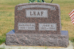
Marjorie Mae Long Leaf
| Birth | : | 10 Feb 1928 Dayton, Webster County, Iowa, USA |
| Death | : | 22 Jan 2009 Boone, Boone County, Iowa, USA |
| Burial | : | South Marion Cemetery, Stratford, Hamilton County, USA |
| Coordinate | : | 42.2327995, -93.8735962 |
| Description | : | Marjorie Mae (Long) Leaf 1928 - 2009 Marjorie Leaf, age 80, of Boone and the Evangelical Free Church Home, died Thursday, January 22, 2009, at the Boone County Hospital. Funeral services will be Sunday, January 25, 2009, at 2:00 p.m. at the Berean Baptist Church with Dr. T. Reynolds Hall officiating. Burial will be in the South Marion Cemetery, southeast of Stratford. Friends may call at Schroeder Memorial Chapel at Sixth and Marshall on Saturday, January 24, 2009, from 6:00 to 8:00 p.m. where the family will be present. Visitation continues Sunday at the Church from 1:00 p.m.... Read More |
frequently asked questions (FAQ):
-
Where is Marjorie Mae Long Leaf's memorial?
Marjorie Mae Long Leaf's memorial is located at: South Marion Cemetery, Stratford, Hamilton County, USA.
-
When did Marjorie Mae Long Leaf death?
Marjorie Mae Long Leaf death on 22 Jan 2009 in Boone, Boone County, Iowa, USA
-
Where are the coordinates of the Marjorie Mae Long Leaf's memorial?
Latitude: 42.2327995
Longitude: -93.8735962
Family Members:
Parent

Spouse

Siblings

Flowers:


Nearby Cemetories:
1. South Marion Cemetery
Stratford, Hamilton County, USA
Coordinate: 42.2327995, -93.8735962
2. Oakwood Cemetery
Stratford, Hamilton County, USA
Coordinate: 42.2942009, -93.9182968
3. Mineral Ridge Cemetery
Ridgeport, Boone County, USA
Coordinate: 42.1749992, -93.9266968
4. Hooks Point Cemetery
Hamilton County, USA
Coordinate: 42.2944530, -93.9199090
5. Hardin Township Cemetery
Hardin Township, Webster County, USA
Coordinate: 42.2411003, -93.9708023
6. Saint Paul Lutheran Cemetery
Boone, Boone County, USA
Coordinate: 42.1700000, -93.8070000
7. Boone County Poor Farm Cemetery
Boone County, USA
Coordinate: 42.1591100, -93.9159000
8. White Cemetery
Boone County, USA
Coordinate: 42.1777992, -93.9636002
9. Lake Center Cemetery
Stanhope, Hamilton County, USA
Coordinate: 42.2482986, -93.7568970
10. Leininger Cemetery
Boone County, USA
Coordinate: 42.1492004, -93.8356018
11. Lawn Hill Cemetery
Stanhope, Hamilton County, USA
Coordinate: 42.2677994, -93.7611008
12. Nesse Cemetery
Hamilton County, USA
Coordinate: 42.3250008, -93.8933029
13. Neese Cemetery
Homer, Hamilton County, USA
Coordinate: 42.3250000, -93.8935000
14. Linn Cemetery
Pilot Mound, Boone County, USA
Coordinate: 42.2045330, -93.9970230
15. Vegors Cemetery
Webster County, USA
Coordinate: 42.3177986, -93.9421997
16. Mackey Cemetery
Boone County, USA
Coordinate: 42.1675000, -93.7565000
17. Runyan Cemetery
Pilot Mound, Boone County, USA
Coordinate: 42.1749992, -94.0015030
18. Saint Pauls Church Cemetery
Jewell, Hamilton County, USA
Coordinate: 42.2490100, -93.7173400
19. Schlicht Cemetery
Fraser, Boone County, USA
Coordinate: 42.1444200, -93.9780100
20. Bass Cemetery
Dayton, Webster County, USA
Coordinate: 42.2966995, -94.0149994
21. Saratoga Cemetery
Stanhope, Hamilton County, USA
Coordinate: 42.3539009, -93.8167038
22. Pilot Mound Cemetery
Pilot Mound, Boone County, USA
Coordinate: 42.1636200, -94.0282600
23. Ellsworth Clear Lake Cemetery
Randall, Hamilton County, USA
Coordinate: 42.2268930, -93.6926200
24. Bass Point Cemetery
Boone, Boone County, USA
Coordinate: 42.0992012, -93.8957977