
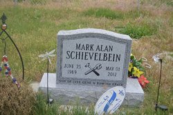
Mark Alan Schievelbein
| Birth | : | 25 Jun 1969 Lebanon, Laclede County, Missouri, USA |
| Death | : | 1 May 2012 Lexington, Dawson County, Nebraska, USA |
| Burial | : | Immanuel Lutheran Cemetery, Elwood, Gosper County, USA |
| Coordinate | : | 40.4206500, -99.8672000 |
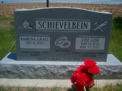
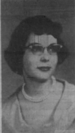
| Description | : | Mark Alan Schievelbein, 42, of Lexington, Nebraska, died Tuesday, May 1, 2012, at his home in Lexington. Mark was born June 25, 1969, in Lebanon, Missouri to Lyle and Ramona (Shepherd) Schievelbein. When he was four the family moved to Elwood, Nebraska, where he grew up. He was active in school sports and loved to wrestle. He graduated from Elwood High School with the class of 1988. Mark was active in Boy Scouts and was proud of the fact that he earned his Eagle Scout. Mark earned his degree from Mid-Plains Community College in Auto-body repair. He loved to work on... Read More |
frequently asked questions (FAQ):
-
Where is Mark Alan Schievelbein's memorial?
Mark Alan Schievelbein's memorial is located at: Immanuel Lutheran Cemetery, Elwood, Gosper County, USA.
-
When did Mark Alan Schievelbein death?
Mark Alan Schievelbein death on 1 May 2012 in Lexington, Dawson County, Nebraska, USA
-
Where are the coordinates of the Mark Alan Schievelbein's memorial?
Latitude: 40.4206500
Longitude: -99.8672000
Family Members:
Parent
Siblings
Flowers:


Nearby Cemetories:
1. Immanuel Lutheran Cemetery
Elwood, Gosper County, USA
Coordinate: 40.4206500, -99.8672000
2. McGuire Cemetery
Gosper County, USA
Coordinate: 40.4380989, -99.8664017
3. Homerville Cemetery
Gosper County, USA
Coordinate: 40.4668999, -99.8593979
4. Pleasant Grove Cemetery
Gosper County, USA
Coordinate: 40.4664001, -99.9250031
5. East Muddy Cemetery
Gosper County, USA
Coordinate: 40.4166985, -99.9614029
6. Fairfield Cemetery
Gosper County, USA
Coordinate: 40.4672012, -99.7549973
7. Arapahoe Cemetery
Arapahoe, Furnas County, USA
Coordinate: 40.3239600, -99.8985500
8. Saint Matthew Lutheran Cemetery
Elwood, Gosper County, USA
Coordinate: 40.3519000, -99.9630000
9. Stump Cemetery
Furnas County, USA
Coordinate: 40.3478012, -99.7621994
10. Salem East Cemetery
Gosper County, USA
Coordinate: 40.4972000, -99.9803009
11. Salem West Cemetery
Frontier County, USA
Coordinate: 40.4968987, -99.9886017
12. Zion Cemetery
Gosper County, USA
Coordinate: 40.4085999, -99.7005997
13. Highland Union Cemetery
Gosper County, USA
Coordinate: 40.3513990, -99.7172360
14. Edison Cemetery
Edison, Furnas County, USA
Coordinate: 40.2919006, -99.7902985
15. Miller Cemetery
Elwood, Gosper County, USA
Coordinate: 40.3514980, -100.0374350
16. Holbrook Cemetery
Holbrook, Furnas County, USA
Coordinate: 40.3138000, -100.0045000
17. Norwegian Lutheran Cemetery
Holbrook, Furnas County, USA
Coordinate: 40.3380910, -100.0425560
18. Yoder Cemetery
Smithfield, Gosper County, USA
Coordinate: 40.4957000, -99.6845500
19. Stowe Cemetery
Stockville, Frontier County, USA
Coordinate: 40.4900017, -100.0753021
20. Garfield Cemetery
Furnas County, USA
Coordinate: 40.2491989, -99.8992004
21. Elwood Cemetery
Elwood, Gosper County, USA
Coordinate: 40.5999300, -99.8397300
22. Highland Cemetery
Bertrand, Phelps County, USA
Coordinate: 40.5194016, -99.6430969
23. Quakerville Cemetery
Gosper County, USA
Coordinate: 40.6189003, -99.8097000
24. Hope Lutheran Cemetery
Smithfield, Gosper County, USA
Coordinate: 40.5667500, -99.6800000