

Marshall Columbus “Lum” Taylor
| Birth | : | 28 May 1905 Monroe County, Kentucky, USA |
| Death | : | 10 Oct 1933 Barren County, Kentucky, USA |
| Burial | : | Rock Springs Cemetery, Celina, Clay County, USA |
| Coordinate | : | 36.6096992, -85.4167023 |
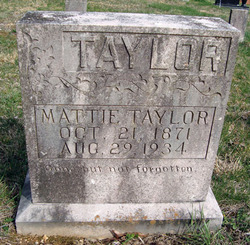
| Description | : | Was thrown from a mule. 1920 Census Wm T Taylor Age 54 Birth Year 1866 Birthplace Tennessee Home in 1920 Leslie, Cumberland, Kentucky Street Upper Washer Bottom House Number Farm Residence Date 1920 Race White Gender Male Relation to Head of House Head Marital Status Married Spouse's Name Mattie Taylor Father's Birthplace North Carolina Mother's Birthplace Tennessee Able to Speak English Yes Occupation Farmer Industry General Farm Employment Field Employe rHome Owned or Rented Owned Home Free or Mortgaged Mortgaged Able to read Yes Able to Write Yes Neighbors View others on page Household Members Name Wm T... Read More |
frequently asked questions (FAQ):
-
Where is Marshall Columbus “Lum” Taylor's memorial?
Marshall Columbus “Lum” Taylor's memorial is located at: Rock Springs Cemetery, Celina, Clay County, USA.
-
When did Marshall Columbus “Lum” Taylor death?
Marshall Columbus “Lum” Taylor death on 10 Oct 1933 in Barren County, Kentucky, USA
-
Where are the coordinates of the Marshall Columbus “Lum” Taylor's memorial?
Latitude: 36.6096992
Longitude: -85.4167023
Family Members:
Parent

Spouse
Siblings

Flowers:


Nearby Cemetories:
1. Rock Springs Cemetery
Celina, Clay County, USA
Coordinate: 36.6096992, -85.4167023
2. Thompson Webb Cemetery
Celina, Clay County, USA
Coordinate: 36.6090110, -85.4202270
3. Crossroads Cemetery
Clay County, USA
Coordinate: 36.6074982, -85.4210968
4. Williams Cemetery
Pea Ridge, Clay County, USA
Coordinate: 36.6150017, -85.4169006
5. Ashlock Cemetery
Ashlock, Cumberland County, USA
Coordinate: 36.6208380, -85.4283620
6. Hattie's Houses Cemetery
Pea Ridge, Clay County, USA
Coordinate: 36.6159200, -85.4360040
7. Mullins - Kerr Cemetery
Pea Ridge, Clay County, USA
Coordinate: 36.5951330, -85.4317470
8. Killman Cemetery
Ashlock, Cumberland County, USA
Coordinate: 36.6325850, -85.4256430
9. Donaldson Cemetery
Pea Ridge, Clay County, USA
Coordinate: 36.5952988, -85.4424973
10. Lester and Winnie Spears Cemetery
Burkesville, Cumberland County, USA
Coordinate: 36.6304420, -85.3829600
11. Bowe Cemetery
Pea Ridge, Clay County, USA
Coordinate: 36.5833015, -85.4439011
12. Smith Cemetery
Monroe County, USA
Coordinate: 36.6439881, -85.4203414
13. Key Cemetery
Pea Ridge, Clay County, USA
Coordinate: 36.5875015, -85.4518967
14. Grover Rich Cemetery
Pea Ridge, Clay County, USA
Coordinate: 36.5946370, -85.4602970
15. Dulworth Cemetery
Cumberland County, USA
Coordinate: 36.6292100, -85.3757900
16. Short's Chapel Cemetery
Monroe County, USA
Coordinate: 36.6281013, -85.4589005
17. Thompson Cemetery
Clay County, USA
Coordinate: 36.6123700, -85.4666600
18. Ray Williams Cemetery
Pea Ridge, Clay County, USA
Coordinate: 36.5856130, -85.4598120
19. Riley Cemetery
Littrell, Cumberland County, USA
Coordinate: 36.6509768, -85.3853975
20. Peyton Spear Cemetery
Peytonsburg, Cumberland County, USA
Coordinate: 36.6481590, -85.3778400
21. Capps-Key Cemetery
Burkesville, Cumberland County, USA
Coordinate: 36.6605280, -85.4129330
22. Pruitt Cemetery
Peytonsburg, Cumberland County, USA
Coordinate: 36.6571270, -85.3874590
23. Spears Chapel Cemetery
Peytonsburg, Cumberland County, USA
Coordinate: 36.6495790, -85.3714410
24. Poplar Grove Cemetery
Kettle, Cumberland County, USA
Coordinate: 36.6680090, -85.4074180