
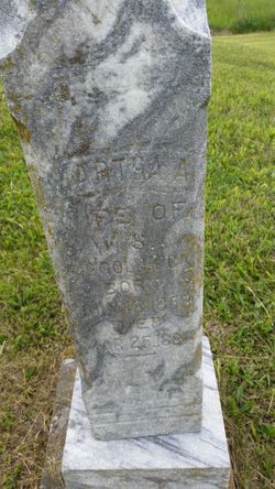
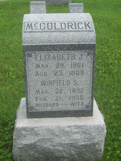
Martha A. Hathaway McGoldrick
| Birth | : | 1858 Schuyler County, Missouri, USA |
| Death | : | 25 Mar 1884 Lancaster, Schuyler County, Missouri, USA |
| Burial | : | Assumption Cemetery, Belmont, Kent County, USA |
| Coordinate | : | 43.0783330, -85.6097220 |
| Description | : | married, aged 25 yrs, 5 mos, 7 days MO Archives pre-1910 d. cert daughter of Preston and Mary Hathaway, married W.S. McGoldrick on January 14, 1883 |
frequently asked questions (FAQ):
-
Where is Martha A. Hathaway McGoldrick's memorial?
Martha A. Hathaway McGoldrick's memorial is located at: Assumption Cemetery, Belmont, Kent County, USA.
-
When did Martha A. Hathaway McGoldrick death?
Martha A. Hathaway McGoldrick death on 25 Mar 1884 in Lancaster, Schuyler County, Missouri, USA
-
Where are the coordinates of the Martha A. Hathaway McGoldrick's memorial?
Latitude: 43.0783330
Longitude: -85.6097220
Family Members:

Flowers:


Nearby Cemetories:
1. Assumption Cemetery
Belmont, Kent County, USA
Coordinate: 43.0783330, -85.6097220
2. Plainfield Cemetery
Plainfield Township, Kent County, USA
Coordinate: 43.0766983, -85.5899963
3. Blythefield Memory Gardens
Belmont, Kent County, USA
Coordinate: 43.0758018, -85.5681000
4. Oakwood Cemetery
Plainfield Township, Kent County, USA
Coordinate: 43.0636400, -85.5705900
5. Friant Cemetery
Grand Rapids, Kent County, USA
Coordinate: 43.0633080, -85.5700280
6. Garden of the Pines
Grand Rapids, Kent County, USA
Coordinate: 43.0422710, -85.6279260
7. Saint Lukes Lutheran Church Memorial Garden
Grand Rapids, Kent County, USA
Coordinate: 43.0288740, -85.5882610
8. Pine Grove Cemetery
Comstock Park, Kent County, USA
Coordinate: 43.0757700, -85.6827600
9. Rockford Cemetery
Rockford, Kent County, USA
Coordinate: 43.1152992, -85.5522003
10. Rockford Pioneer Cemetery
Rockford, Kent County, USA
Coordinate: 43.1177780, -85.5525000
11. Englishville Cemetery
Comstock Park, Kent County, USA
Coordinate: 43.1041985, -85.6800003
12. United Church of Christ Cemetery
Comstock Park, Kent County, USA
Coordinate: 43.0359210, -85.6684260
13. Mill Creek Cemetery
Walker, Kent County, USA
Coordinate: 43.0288890, -85.6705560
14. Saint Andrews Episcopal Gardens
Grand Rapids, Kent County, USA
Coordinate: 43.0142030, -85.6430840
15. Grand Rapids Veterans Home Cemetery
Grand Rapids, Kent County, USA
Coordinate: 43.0182915, -85.6588898
16. Holy Trinity Cemetery
Alpine Township, Kent County, USA
Coordinate: 43.0511017, -85.6992035
17. Briggs Family Cemetery
Rockford, Kent County, USA
Coordinate: 43.1391670, -85.5508330
18. Mason Cemetery
Grand Rapids, Kent County, USA
Coordinate: 43.0056000, -85.5849991
19. Algoma Township Cemetery
Rockford, Kent County, USA
Coordinate: 43.1563988, -85.6252975
20. Fairplains Cemetery
Grand Rapids, Kent County, USA
Coordinate: 43.0005989, -85.6421967
21. Second Congregational UCC Memorial Garden
Grand Rapids, Kent County, USA
Coordinate: 43.0032900, -85.6549900
22. Alpine Center Cemetery
Comstock Park, Kent County, USA
Coordinate: 43.0724983, -85.7285995
23. Cannonsburg Cemetery
Belmont, Kent County, USA
Coordinate: 43.0647011, -85.4796982
24. Fairplains Cemetery
Sparta, Kent County, USA
Coordinate: 43.1528015, -85.6988983