

Martha B. Cole Ronfeldt
| Birth | : | Nov 1861 Michigan, USA |
| Death | : | Jul 1948 Calhoun County, Iowa, USA |
| Burial | : | Lake City Cemetery, Lake City, Calhoun County, USA |
| Coordinate | : | 42.2719002, -94.7574997 |
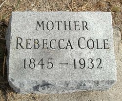
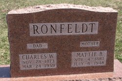
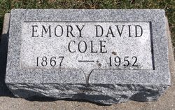
| Description | : | Daughter of Charles and Rebecca Cole; sister of Jerome, Emory, and Carrie. The family lived at Calhoun Township, Calhoun County, Iowa in the 1870 census. Martha married James S. Tappan on February 20, 1878 in Calhoun County, Iowa and they were the parents of ten children/eight living in the 1900 census. They lived in Polk County, Des Moines,Iowa where her husband was a Teamster. Children were: Ralph D., James E., William A., Grover C., Milton J., Franklin C., Fred H., and George R. A daughter, Anna, was listed in the 1880, 1885, and 1895 census records. Martha married Charles Ronfeldt... Read More |
frequently asked questions (FAQ):
-
Where is Martha B. Cole Ronfeldt's memorial?
Martha B. Cole Ronfeldt's memorial is located at: Lake City Cemetery, Lake City, Calhoun County, USA.
-
When did Martha B. Cole Ronfeldt death?
Martha B. Cole Ronfeldt death on Jul 1948 in Calhoun County, Iowa, USA
-
Where are the coordinates of the Martha B. Cole Ronfeldt's memorial?
Latitude: 42.2719002
Longitude: -94.7574997
Family Members:
Parent

Spouse
Siblings
Children
Flowers:


Nearby Cemetories:
1. Lake City Cemetery
Lake City, Calhoun County, USA
Coordinate: 42.2719002, -94.7574997
2. Saint Marys Catholic Cemetery
Lake City, Calhoun County, USA
Coordinate: 42.2730000, -94.7567000
3. Cottonwood Cemetery
Lake City, Calhoun County, USA
Coordinate: 42.2491989, -94.7936020
4. Saint Marys Cemetery
Sac County, USA
Coordinate: 42.2611008, -94.8839035
5. Lanesboro Cemetery
Lanesboro, Carroll County, USA
Coordinate: 42.1810989, -94.7230988
6. Oak Lawn Cemetery
Auburn, Sac County, USA
Coordinate: 42.2611008, -94.8852997
7. Bishop Cemetery
Calhoun Township, Calhoun County, USA
Coordinate: 42.2230400, -94.6453190
8. Lake Creek Cemetery
Calhoun County, USA
Coordinate: 42.3394012, -94.6631012
9. Grant City Cemetery
Grant City, Sac County, USA
Coordinate: 42.2681007, -94.8908005
10. East Liberty Cemetery
Lidderdale, Carroll County, USA
Coordinate: 42.1591988, -94.7636032
11. Saint Peters Lutheran Cemetery
Sac County, USA
Coordinate: 42.3543000, -94.8868000
12. Lutheran Emanuel Cemetery
Coon Valley Township, Sac County, USA
Coordinate: 42.3692017, -94.8771973
13. Luckow Cemetery
Auburn, Sac County, USA
Coordinate: 42.2168999, -94.9266968
14. Immanuel Cemetery
Lidderdale, Carroll County, USA
Coordinate: 42.1389008, -94.8022003
15. Holy Family Cemetery
Lidderdale, Carroll County, USA
Coordinate: 42.1178017, -94.7839966
16. Garfield Cemetery
Calhoun County, USA
Coordinate: 42.4275017, -94.7902985
17. North Coon Cemetery
Carroll County, USA
Coordinate: 42.1260986, -94.6716995
18. Our Lady Of Mount Carmel Cemetery
Mount Carmel, Carroll County, USA
Coordinate: 42.1547012, -94.9088974
19. Evergreen Cemetery
Lohrville, Calhoun County, USA
Coordinate: 42.2505989, -94.5330963
20. Reformatory Cemetery
Rockwell City, Calhoun County, USA
Coordinate: 42.3952570, -94.6038660
21. Rosehill Cemetery
Rockwell City, Calhoun County, USA
Coordinate: 42.4042015, -94.6128006
22. Dickson Cemetery
Glidden Township, Carroll County, USA
Coordinate: 42.1074982, -94.6939011
23. Saint Francis Cemetery
Rockwell City, Calhoun County, USA
Coordinate: 42.4055000, -94.6127000
24. Twin Lakes Cemetery
Jolley, Calhoun County, USA
Coordinate: 42.4427986, -94.6889038