
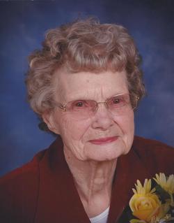
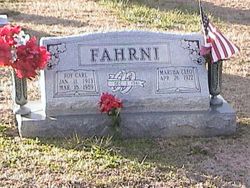
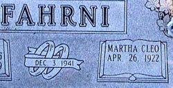
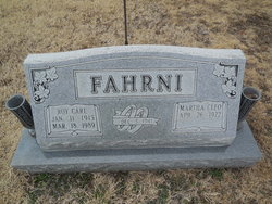
Martha Cleophia Howlett Fahrni
| Birth | : | 26 Apr 1922 Russellville, Cole County, Missouri, USA |
| Death | : | 13 Oct 2016 California, Moniteau County, Missouri, USA |
| Burial | : | Enloe Cemetery, Moniteau County, USA |
| Coordinate | : | 38.5074997, -92.4741974 |
| Description | : | The Lord called Martha Cleophia Howlett Fahrni to her eternal rest on Thursday, October 13, 2016 at Moniteau Care Center. Having been granted an earthly life of 94 years. It was on April 26, 1922 at the Calhoun homestead near Russellville, Mo., that the Lord blessed the home of Lucian G. and Sadie G. Enloe Howlett with their third child a daughter, Martha Cleophia Howlett. Cleo publicly confessed her faith in Jesus Christ as Savior at Corticelli Baptist Church being a member for six years. She then joined Hopewell Union Church for 43 years, Barnett, Mo. then a member at... Read More |
frequently asked questions (FAQ):
-
Where is Martha Cleophia Howlett Fahrni's memorial?
Martha Cleophia Howlett Fahrni's memorial is located at: Enloe Cemetery, Moniteau County, USA.
-
When did Martha Cleophia Howlett Fahrni death?
Martha Cleophia Howlett Fahrni death on 13 Oct 2016 in California, Moniteau County, Missouri, USA
-
Where are the coordinates of the Martha Cleophia Howlett Fahrni's memorial?
Latitude: 38.5074997
Longitude: -92.4741974
Family Members:
Parent

Spouse
Siblings
Flowers:


Nearby Cemetories:
1. Enloe Cemetery
Moniteau County, USA
Coordinate: 38.5074997, -92.4741974
2. Belleville Cemetery
Russellville, Cole County, USA
Coordinate: 38.4970490, -92.4667150
3. Enon Cemetery
Russellville, Cole County, USA
Coordinate: 38.4888992, -92.4730988
4. Karnes-Carney-Henderson Cemetery
Burris Fork, Moniteau County, USA
Coordinate: 38.4992100, -92.5007510
5. Saint Michael Cemetery
Russellville, Cole County, USA
Coordinate: 38.5109300, -92.4429100
6. Evangelical Lutheran Cemetery One Acre
Russellville, Cole County, USA
Coordinate: 38.5175667, -92.4415817
7. Buckner Russell Cemetery
Cole County, USA
Coordinate: 38.5136900, -92.4359390
8. Van Pool Cemetery
Moniteau County, USA
Coordinate: 38.5372009, -92.4627991
9. Russellville Cemetery
Russellville, Cole County, USA
Coordinate: 38.5196991, -92.4366989
10. Trinity Lutheran Cemetery
Russellville, Cole County, USA
Coordinate: 38.5028000, -92.4317017
11. Karnes Cemetery
Corticelli, Moniteau County, USA
Coordinate: 38.5099700, -92.5247900
12. Campbell Cemetery
Cole County, USA
Coordinate: 38.4810982, -92.4297028
13. Blank Cemetery
Russellville, Cole County, USA
Coordinate: 38.5203018, -92.4180984
14. DeFoe Cemetery
California, Moniteau County, USA
Coordinate: 38.5416985, -92.5250015
15. Rock Enon Cemetery
Miller County, USA
Coordinate: 38.4668400, -92.5170700
16. Bruce-Lewis-McGahan Cemetery
Enon, Moniteau County, USA
Coordinate: 38.4667500, -92.5172100
17. Roark Cemetery
Russellville, Cole County, USA
Coordinate: 38.4696999, -92.4255981
18. Matheis Cemetery
Russellville, Cole County, USA
Coordinate: 38.4571800, -92.4491600
19. Barnhardt Cemetery
Lohman, Cole County, USA
Coordinate: 38.5537900, -92.4267100
20. Clibourn Cemetery
Russellville, Cole County, USA
Coordinate: 38.4760500, -92.3973500
21. Marney Family Cemetery
High Point, Moniteau County, USA
Coordinate: 38.5357900, -92.5614500
22. Jackson Chapel Methodist Church Cemetery
California, Moniteau County, USA
Coordinate: 38.4447900, -92.5286500
23. Yarnell Cemetery
California, Moniteau County, USA
Coordinate: 38.5189018, -92.5708008
24. Gray Cemetery
Moniteau County, USA
Coordinate: 38.4536018, -92.5456009