

Martha E. “Matt” Muldoon Muldoon
| Birth | : | 15 Oct 1905 Batavia, Jefferson County, Iowa, USA |
| Death | : | 17 May 1994 Ottumwa, Wapello County, Iowa, USA |
| Burial | : | New Hope Cemetery, Pollard, Clay County, USA |
| Coordinate | : | 36.4272400, -90.2790400 |
| Plot | : | 168 - 2nd |
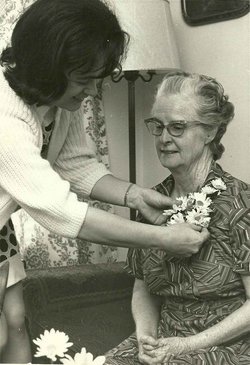
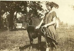
| Description | : | Martha Muldoon grew up on a farm in Wapello County, IA, with her sisters May and Bessie. Her delayed birth cert says she was born in Batavia. She had a teaching certificate and later graduated from Drake University in 1960. She taught school in Wapello County for 44 years, including Center and Eisenhower Schools. She was a member of St. Patrick's Church in Ottumwa, IA. She and her sister Bessie shared a home in Ottumwa, IA until Martha entered a nursing home, where Bessie visited her every day. |
frequently asked questions (FAQ):
-
Where is Martha E. “Matt” Muldoon Muldoon's memorial?
Martha E. “Matt” Muldoon Muldoon's memorial is located at: New Hope Cemetery, Pollard, Clay County, USA.
-
When did Martha E. “Matt” Muldoon Muldoon death?
Martha E. “Matt” Muldoon Muldoon death on 17 May 1994 in Ottumwa, Wapello County, Iowa, USA
-
Where are the coordinates of the Martha E. “Matt” Muldoon Muldoon's memorial?
Latitude: 36.4272400
Longitude: -90.2790400
Family Members:
Parent
Siblings
Flowers:


Nearby Cemetories:
1. New Hope Cemetery
Pollard, Clay County, USA
Coordinate: 36.4272400, -90.2790400
2. Holcomb Cemetery
Pollard, Clay County, USA
Coordinate: 36.4321594, -90.2577896
3. Cummings Chapel Methodist Church Cemetery
Pollard, Clay County, USA
Coordinate: 36.4019012, -90.2932968
4. Thomas Cemetery
Clay County, USA
Coordinate: 36.4478607, -90.2491913
5. Fitzgerald Cemetery
Clay County, USA
Coordinate: 36.3933754, -90.2860718
6. Little Flock Cemetery
Pollard, Clay County, USA
Coordinate: 36.3950005, -90.2453003
7. Rogers Cemetery
Clay County, USA
Coordinate: 36.3939018, -90.3178024
8. Crocketts Cemetery
Boydsville, Clay County, USA
Coordinate: 36.4185982, -90.3383026
9. Williams Cemetery
Greenway, Clay County, USA
Coordinate: 36.3741989, -90.2686005
10. Powers Cemetery
Butler County, USA
Coordinate: 36.4272000, -90.3536000
11. Underwood Cemetery
Clay County, USA
Coordinate: 36.3656006, -90.2639008
12. Heritage Park Historical Cemetery
Piggott, Clay County, USA
Coordinate: 36.3826141, -90.2235641
13. Hardin Chapel Cemetery
Clay County, USA
Coordinate: 36.3755989, -90.3405991
14. Mars Hill Cemetery
Crockett, Clay County, USA
Coordinate: 36.3624992, -90.3275604
15. Gravel Hill Cemetery
Saint Francis, Clay County, USA
Coordinate: 36.4650002, -90.1905975
16. Piggott Memorial Gardens
Piggott, Clay County, USA
Coordinate: 36.3736000, -90.2011032
17. Sarver Cemetery
Clay County, USA
Coordinate: 36.4074287, -90.1787109
18. Hall Cemetery
Saint Francis, Clay County, USA
Coordinate: 36.4518394, -90.1750488
19. Winston Cemetery
Clay County, USA
Coordinate: 36.3464012, -90.2382965
20. Travillian Cemetery
Clay County, USA
Coordinate: 36.3382988, -90.2842026
21. Young Cemetery
McDougal, Clay County, USA
Coordinate: 36.3830910, -90.3751526
22. Mitchell Cemetery
Greenway, Clay County, USA
Coordinate: 36.3352013, -90.2378464
23. Post Oak Cemetery
McDougal, Clay County, USA
Coordinate: 36.4536514, -90.3967590
24. Lone Grave
Clay County, USA
Coordinate: 36.3358002, -90.3331070