
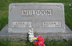
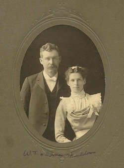
William Thomas “Sonny” Muldoon
| Birth | : | 30 Apr 1870 Wapello County, Iowa, USA |
| Death | : | 10 Mar 1955 Wapello County, Iowa, USA |
| Burial | : | Harrell Cemetery, Bean Station, Grainger County, USA |
| Coordinate | : | 36.3074989, -83.3463974 |
| Plot | : | 2ND ADD~LOT 168 |
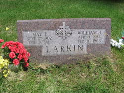
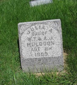
| Description | : | William Thomas ("Sonny") Muldoon's was the son of Barney Muldoon and Elizabeth Downey. His baptismal sponsor at St. Mary's Church of Ottumwa was Francis Jane-Lucretia Dean. An informal family history notes that Anna Parret and her husband lived on Anna's father's farm for a few years, until they had their own, in Wapello County, IA. Sonny and his wife, Anna J. Parrett, had four daughters, three of whom grew to be adults. All of these women (May, Bessie and Martha) taught school in Wapello County. His daughter Bessie remembers that they had a strip of coal... Read More |
frequently asked questions (FAQ):
-
Where is William Thomas “Sonny” Muldoon's memorial?
William Thomas “Sonny” Muldoon's memorial is located at: Harrell Cemetery, Bean Station, Grainger County, USA.
-
When did William Thomas “Sonny” Muldoon death?
William Thomas “Sonny” Muldoon death on 10 Mar 1955 in Wapello County, Iowa, USA
-
Where are the coordinates of the William Thomas “Sonny” Muldoon's memorial?
Latitude: 36.3074989
Longitude: -83.3463974
Family Members:
Parent
Spouse
Siblings


Children
Flowers:


Nearby Cemetories:
1. Harrell Cemetery
Bean Station, Grainger County, USA
Coordinate: 36.3074989, -83.3463974
2. Marys Chapel Cemetery
Grainger County, USA
Coordinate: 36.3011017, -83.3569031
3. Noeton Baptist Church Cemetery Original
Bean Station, Grainger County, USA
Coordinate: 36.3012600, -83.3342200
4. Harris Cemetery
Grainger County, USA
Coordinate: 36.3055992, -83.3308029
5. Cobb Cemetery
Grainger County, USA
Coordinate: 36.3189011, -83.3644028
6. Heath Chapel Cemetery
Grainger County, USA
Coordinate: 36.2851730, -83.3615220
7. Bean Station Cemetery
Bean Station, Grainger County, USA
Coordinate: 36.3283000, -83.3697000
8. Buck Hollow Cemetery
Grainger County, USA
Coordinate: 36.3344120, -83.3589440
9. Ford Cemetery
Grainger County, USA
Coordinate: 36.2902985, -83.3071976
10. Lakeshore Missionary Baptist Church Cemetery
Bean Station, Grainger County, USA
Coordinate: 36.2797470, -83.3780200
11. Dalton Cemetery
Bean Station, Grainger County, USA
Coordinate: 36.3428001, -83.3296967
12. Macedonia Missionary Baptist Church Cemetery
Morristown, Hamblen County, USA
Coordinate: 36.2696100, -83.3301400
13. Holston Baptist Church Cemetery
Bean Station, Grainger County, USA
Coordinate: 36.2775002, -83.3796997
14. Samsel Cemetery
Bean Station, Grainger County, USA
Coordinate: 36.3424020, -83.3167060
15. Samsel Cemetery
Bean Station, Grainger County, USA
Coordinate: 36.3114014, -83.2925034
16. Freedom Chapel Missionary Baptist Church Cemetery
Grainger County, USA
Coordinate: 36.2865410, -83.3948480
17. Garrett Cemetery
Grainger County, USA
Coordinate: 36.3414001, -83.3082962
18. Helton Cemetery
Bean Station, Grainger County, USA
Coordinate: 36.2910995, -83.3993988
19. Samsel Lakeview Cemetery
Bean Station, Grainger County, USA
Coordinate: 36.3475800, -83.3189468
20. Adriel Baptist Church Cemetery
Bean Station, Grainger County, USA
Coordinate: 36.3125000, -83.2897034
21. Helton Cemetery
Bean Station, Grainger County, USA
Coordinate: 36.3451190, -83.3831290
22. Dodson Cemetery
Bean Station, Grainger County, USA
Coordinate: 36.2989006, -83.2869034
23. Taylor Family Cemetery
Bean Station, Grainger County, USA
Coordinate: 36.2876670, -83.2907330
24. First Independent Freewill Baptist Church Cemetery
Bean Station, Grainger County, USA
Coordinate: 36.3158860, -83.2855850