
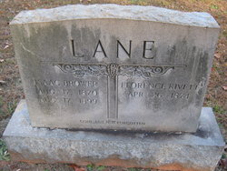
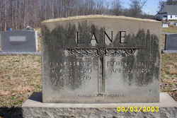
Martha Florence Kivett Lane
| Birth | : | 26 Apr 1874 |
| Death | : | 24 Feb 1960 Asheboro, Randolph County, North Carolina, USA |
| Burial | : | Bethany United Methodist Church Cemetery #2, Liberty, Randolph County, USA |
| Coordinate | : | 35.8430060, -79.5948160 |
| Description | : | Father: Stanley KIVETT b: 11 APR 1833 in NC Mother: Mary WRIGHTSMON b: 19 APR 1848 in NC Marriage 1 Isaac Brower Lane b: 17 AUG 1870 Married December 27, 1894 in Randolph County, NC Marriage 2 James Randolph Brown b: 1861 Married November November 16, 1911 Greensboro Daily News, NC February 25, 1960 MRS. FLORENCE BROWN LIBERTY, Feb. 24 - Mrs. Florence Lane Brown, 85, former resident of Route 1, Liberty, died in Asheboro Tuesday after a long illness. She is survived by one son, C. T. Lane of Route 1, Staley; three brothers, Isaac and Daniel Kivett of Route 1, Liberty, and Larkin Kivett of... Read More |
frequently asked questions (FAQ):
-
Where is Martha Florence Kivett Lane's memorial?
Martha Florence Kivett Lane's memorial is located at: Bethany United Methodist Church Cemetery #2, Liberty, Randolph County, USA.
-
When did Martha Florence Kivett Lane death?
Martha Florence Kivett Lane death on 24 Feb 1960 in Asheboro, Randolph County, North Carolina, USA
-
Where are the coordinates of the Martha Florence Kivett Lane's memorial?
Latitude: 35.8430060
Longitude: -79.5948160
Family Members:
Spouse

Flowers:


Nearby Cemetories:
1. Bethany United Methodist Church Cemetery #2
Liberty, Randolph County, USA
Coordinate: 35.8430060, -79.5948160
2. Amos Grove Cemetery
Liberty, Randolph County, USA
Coordinate: 35.8546982, -79.5871964
3. Saint Stephen Memorial Gardens
Liberty, Randolph County, USA
Coordinate: 35.8550750, -79.5877970
4. Fairview Cemetery
Liberty, Randolph County, USA
Coordinate: 35.8516998, -79.5761032
5. Mount Pleasant Baptist Church Cemetery
Staley, Randolph County, USA
Coordinate: 35.8144700, -79.5790000
6. Liberty Grove Methodist Church Cemetery
Liberty, Randolph County, USA
Coordinate: 35.8733140, -79.5709950
7. McMasters Cemetery
Randolph County, USA
Coordinate: 35.8072370, -79.6021500
8. Melanchthon Lutheran Church Cemetery
Liberty, Randolph County, USA
Coordinate: 35.8451630, -79.6440640
9. Margarets Chapel Church Cemetery
Staley, Randolph County, USA
Coordinate: 35.8110940, -79.5648900
10. Sandy Creek Primitive Baptist Church Cemetery
Liberty, Randolph County, USA
Coordinate: 35.8239020, -79.6406560
11. Sandy Creek Baptist Church Cemetery
Liberty, Randolph County, USA
Coordinate: 35.8235550, -79.6429050
12. Olivers Chapel Cemetery
Staley, Randolph County, USA
Coordinate: 35.8060989, -79.5610962
13. Macedonia Baptist Church Cemetery
Liberty, Randolph County, USA
Coordinate: 35.8960090, -79.6075490
14. Lineberry Family Cemetery
Staley, Randolph County, USA
Coordinate: 35.7878000, -79.5724000
15. Old Shady Grove Cemetery
Staley, Randolph County, USA
Coordinate: 35.7874985, -79.5725021
16. Shady Grove Baptist Church Cemetery
Staley, Randolph County, USA
Coordinate: 35.7853800, -79.5821020
17. Hickory Grove Methodist Church Cemetery
Albright Township, Chatham County, USA
Coordinate: 35.8407560, -79.5217650
18. Hollys Chapel Pentecostal Holiness Church
Ramseur, Randolph County, USA
Coordinate: 35.7825600, -79.6048200
19. Staley City Cemetery
Staley, Randolph County, USA
Coordinate: 35.7918300, -79.5507100
20. Oak Grove Baptist Church Cemetery
Snow Camp, Alamance County, USA
Coordinate: 35.8873490, -79.5330180
21. Richland Cemetery
Liberty, Randolph County, USA
Coordinate: 35.8996315, -79.5469894
22. Whites Chapel United Methodist Church Cemetery
Liberty, Randolph County, USA
Coordinate: 35.7850520, -79.6422990
23. Shiloh United Methodist Church Cemetery
Liberty, Randolph County, USA
Coordinate: 35.8915430, -79.6594990
24. Smithwood United Church of Christ Cemetery
Guilford County, USA
Coordinate: 35.9113900, -79.5605600